National Register of Historic Places listings in Ben Hill County, Georgia
- This National Park Service list is complete through NPS recent listings posted August 14, 2020.[1]
Current listings
| [2] | Name on the Register | Image | Date listed[3] | Location | City or town | Description |
|---|---|---|---|---|---|---|
| 1 | Ben Hill County Courthouse | 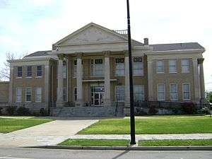 Ben Hill County Courthouse |
September 18, 1980 (#80000973) |
E. Central Ave. 31°42′52″N 83°15′34″W |
Fitzgerald | |
| 2 | Ben Hill County Jail | 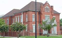 Ben Hill County Jail |
August 26, 1982 (#82002383) |
Pine St. 31°42′50″N 83°14′59″W |
Fitzgerald | |
| 3 | Dorminy-Massee House | 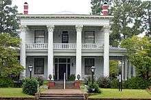 Dorminy-Massee House |
May 26, 2000 (#00000529) |
516 W. Central Ave. 31°42′51″N 83°15′35″W |
Fitzgerald | website |
| 4 | Fitzgerald Commercial Historic District | 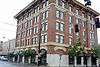 Fitzgerald Commercial Historic District |
April 28, 1992 (#92000383) |
Roughly bounded by Ocmulgee, Thomas, Magnolia and Lee Sts. 31°42′51″N 83°15′09″W |
Fitzgerald | |
| 5 | Holtzendorf Apartments | 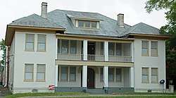 Holtzendorf Apartments |
January 12, 1988 (#87001905) |
105 W. Pine St. 31°42′50″N 83°15′18″W |
Fitzgerald | |
| 6 | South Main-South Lee Streets Historic District |  South Main-South Lee Streets Historic District |
April 13, 1989 (#89000294) |
Roughly bounded by Magnolia St., S. Main St., Roanoke Dr., and S. Lee St. 31°42′32″N 83°15′18″W |
Fitzgerald | |
| 7 | Miles V. Wilsey House |  Miles V. Wilsey House |
February 23, 2001 (#01000166) |
137 Hudson Rd. 31°44′00″N 83°13′54″W |
Fitzgerald |
gollark: And Rust generally requires more dependencies to do anything.
gollark: I mean, it's probably also a function of dependencies, but my Rust project took about 30 seconds to compile and the Nim one about 5.
gollark: Also, the compiler is really slow.
gollark: True to some extent, I think, but it also ends up causing me to have to do more work for approximately the same output in some areas.
gollark: Skynet was written in Rust some years back and it works perfectly with essentially zero CPU use and no maintenence.
References
- "National Register of Historic Places: Weekly List Actions". National Park Service, United States Department of the Interior. Retrieved on August 14, 2020.
- Numbers represent an ordering by significant words. Various colorings, defined here, differentiate National Historic Landmarks and historic districts from other NRHP buildings, structures, sites or objects.
- The eight-digit number below each date is the number assigned to each location in the National Register Information System database, which can be viewed by clicking the number.
| Wikimedia Commons has media related to National Register of Historic Places in Ben Hill County, Georgia. |
| Topics | |
|---|---|
| Lists by state |
|
| Lists by insular areas | |
| Lists by associated state | |
| Other areas | |
| Related | |
| |
This article is issued from Wikipedia. The text is licensed under Creative Commons - Attribution - Sharealike. Additional terms may apply for the media files.