National Register of Historic Places listings in Dougherty County, Georgia
This is a list of properties and districts in Dougherty County, Georgia that are listed on the National Register of Historic Places (NRHP).
- This National Park Service list is complete through NPS recent listings posted August 14, 2020.[1]
Current listings
| [2] | Name on the Register | Image | Date listed[3] | Location | City or town | Description |
|---|---|---|---|---|---|---|
| 1 | Albany District Pecan Growers' Exchange | 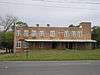 Albany District Pecan Growers' Exchange |
May 10, 1984 (#84000979) |
211-213 Roosevelt Ave. 31°34′53″N 84°09′06″W |
Albany | |
| 2 | Albany Housefurnishing Company | 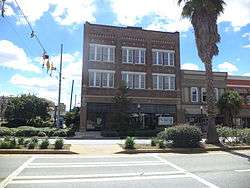 Albany Housefurnishing Company |
June 17, 1982 (#82002402) |
226 W. Broad Ave. 31°34′35″N 84°09′09″W |
Albany | |
| 3 | Albany Railroad Depot Historic District | 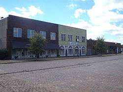 Albany Railroad Depot Historic District |
May 20, 1982 (#82002403) |
E. Roosevelt Ave. 31°34′55″N 84°09′00″W |
Albany | |
| 4 | Albany Theatre | 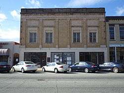 Albany Theatre |
August 21, 2006 (#06000733) |
107 N. Jackson St. 31°34′37″N 84°09′14″W |
Albany | |
| 5 | Bridge House | .JPG) Bridge House |
November 19, 1974 (#74000672) |
112 N. Front St. 31°34′40″N 84°08′56″W |
Albany | |
| 6 | Carnegie Library of Albany | .JPG) Carnegie Library of Albany |
July 15, 1982 (#82002404) |
215 N. Jackson St. 31°34′44″N 84°09′14″W |
Albany | |
| 7 | John A. Davis House | 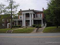 John A. Davis House |
October 16, 1980 (#80001014) |
514 Pine Ave. 31°34′41″N 84°09′38″W |
Albany | |
| 8 | Davis-Exchange Bank Building | 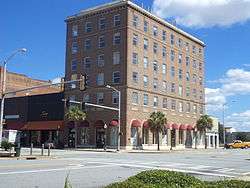 Davis-Exchange Bank Building |
February 23, 1984 (#84000981) |
100-102 N. Washington St. 31°34′37″N 84°09′04″W |
Albany | |
| 9 | Samuel Farkas House | 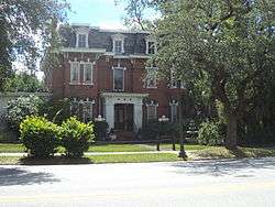 Samuel Farkas House |
November 9, 1977 (#77000419) |
328 W. Broad Ave. 31°34′35″N 84°09′18″W |
Albany | |
| 10 | Lustron House at 1200 Fifth Avenue | March 18, 1996 (#96000214) |
1200 Fifth Ave. 31°35′34″N 84°10′42″W |
Albany | ||
| 11 | Lustron House at 711 Ninth Avenue | March 18, 1996 (#96000213) |
711 Ninth Ave. 31°35′53″N 84°10′00″W |
Albany | Coordinates given are on the wrong block (a block to the south) | |
| 12 | Mount Zion Baptist Church | 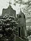 Mount Zion Baptist Church |
August 10, 1995 (#95000911) |
328 W. Whitney Ave. 31°34′18″N 84°09′20″W |
Albany | |
| 13 | Municipal Auditorium | .JPG) Municipal Auditorium |
June 25, 1974 (#74000673) |
301 Pine Ave. 31°34′43″N 84°09′16″W |
Albany | |
| 14 | New Albany Hotel | 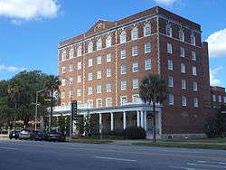 New Albany Hotel |
June 17, 1982 (#82002405) |
245 Pine St. 31°34′49″N 84°09′05″W |
Albany | |
| 15 | Old St. Teresa's Catholic Church | 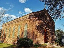 Old St. Teresa's Catholic Church |
April 1, 1975 (#75000589) |
313 Residence Ave. 31°34′59″N 84°09′17″W |
Albany | |
| 16 | Rosenberg Brothers Department Store | 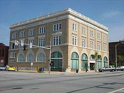 Rosenberg Brothers Department Store |
August 19, 1982 (#82002406) |
126 N. Washington St. 31°34′41″N 84°09′04″W |
Albany | Albany Herald Headquarters |
| 17 | W. E. Smith House | 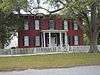 W. E. Smith House |
August 30, 1977 (#77000420) |
516 Flint Ave. 31°34′46″N 84°09′37″W |
Albany | First brick house in Albany |
| 18 | St. Nicholas Hotel | 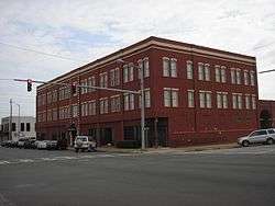 St. Nicholas Hotel |
December 19, 1991 (#91001851) |
141 Flint Ave., 300-310 Washington St. 31°34′48″N 84°09′05″W |
Albany | |
| 19 | Tift Park | 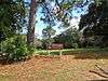 Tift Park |
November 15, 1993 (#93001179) |
Bounded by N. Jefferson St., 5th Ave., 7th Ave. and Palmyra Rd. 31°35′38″N 84°09′31″W |
Albany | |
| 20 | U.S. Post Office and Courthouse | %2C_Albany_(Dougherty_County%2C_Georgia).jpg) U.S. Post Office and Courthouse |
June 22, 1979 (#79003105) |
345 W. Broad Ave. 31°34′38″N 84°09′20″W |
Albany | |
| 21 | Union Station Depot | 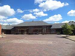 Union Station Depot |
February 13, 1975 (#75000590) |
Roosevelt Ave. and N. Front St. 31°34′54″N 84°08′59″W |
Albany |
gollark: Apparently.
gollark: ?charinfo ⎕
gollark: Hmm, maybe I am to learn how to use `mmap` and other fun syscalls, for osmarksmalloc™.
gollark: I was confused and thought they meant *total* memory allocated or something. If it was just the size of the allocation it would... make sense, but probably be bee in various ways.
gollark: I could even implement an optimization in case your code is cool and frees many things, to prevent RAM overmetahyperuse.
References
- "National Register of Historic Places: Weekly List Actions". National Park Service, United States Department of the Interior. Retrieved on August 14, 2020.
- Numbers represent an ordering by significant words. Various colorings, defined here, differentiate National Historic Landmarks and historic districts from other NRHP buildings, structures, sites or objects.
- The eight-digit number below each date is the number assigned to each location in the National Register Information System database, which can be viewed by clicking the number.
| Wikimedia Commons has media related to National Register of Historic Places in Dougherty County, Georgia. |
| Topics | |
|---|---|
| Lists by state |
|
| Lists by insular areas | |
| Lists by associated state | |
| Other areas | |
| Related | |
| |
This article is issued from Wikipedia. The text is licensed under Creative Commons - Attribution - Sharealike. Additional terms may apply for the media files.