National Register of Historic Places listings in Stewart County, Georgia
This is a list of properties and districts in Stewart County, Georgia that are listed on the National Register of Historic Places (NRHP).
- This National Park Service list is complete through NPS recent listings posted August 14, 2020.[1]
Current listings
| [2] | Name on the Register | Image | Date listed[3] | Location | City or town | Description |
|---|---|---|---|---|---|---|
| 1 | Armstrong House | .jpg) Armstrong House |
June 29, 1982 (#82002466) |
Broad St. 32°03′04″N 84°47′34″W |
Lumpkin | |
| 2 | Bedingfield Inn | 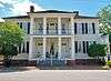 Bedingfield Inn |
May 7, 1973 (#73000643) |
Cotton St. 32°03′02″N 84°47′44″W |
Lumpkin | Built c. 1836 |
| 3 | Bush-Usher House | June 29, 1982 (#82002467) |
E. Main St. 32°02′58″N 84°47′29″W |
Lumpkin | ||
| 4 | Dr. Miller's Office | June 29, 1982 (#82002468) |
E. Main St. 32°03′00″N 84°47′31″W |
Lumpkin | ||
| 5 | East Main Street Residential Historic District | June 29, 1982 (#82002469) |
E. Main St. 32°02′59″N 84°47′34″W |
Lumpkin | ||
| 6 | Green Grove Church, School, and Cemetery | .jpg) Green Grove Church, School, and Cemetery |
June 20, 1995 (#95000734) |
4062 Old Lumpkin-Eufaula Rd. 32°00′26″N 84°51′44″W |
Lumpkin | |
| 7 | Dr. R. L. Grier House | June 29, 1982 (#82002470) |
Broad St. 32°03′04″N 84°48′10″W |
Lumpkin | ||
| 8 | George Y. Harrell House | June 29, 1982 (#82002471) |
Broad St. 32°03′02″N 84°48′09″W |
Lumpkin | ||
| 9 | Jared Irwin House | June 29, 1982 (#82002472) |
E. Main St. 32°02′58″N 84°47′31″W |
Lumpkin | ||
| 10 | Louvale Church Row Historic District | .jpg) Louvale Church Row Historic District |
April 11, 1986 (#86000747) |
US 27 32°10′38″N 84°49′31″W |
Louvale | |
| 11 | Lumpkin Commercial Historic District | 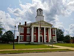 Lumpkin Commercial Historic District |
June 29, 1982 (#82002473) |
Main, Broad, Cotton, and Mulberry Sts. 32°03′00″N 84°47′41″W |
Lumpkin | |
| 12 | Mathis House | June 29, 1982 (#82002474) |
E. Main St. 32°03′00″N 84°47′28″W |
Lumpkin | ||
| 13 | Dr. Thomas B. Miller House | .JPG) Dr. Thomas B. Miller House |
March 2, 1988 (#87001900) |
97 Nicholson St. 32°05′17″N 84°40′06″W |
Richland | |
| 14 | Old Chattahoochee County Courthouse |  Old Chattahoochee County Courthouse |
September 18, 1980 (#80001233) |
3557 South Lumpkin Road 32°23′02″N 84°57′31″W |
Columbus | One of three antebellum courthouses still existing in Georgia. Currently part of the Historic Westville museum in Columbus. |
| 15 | Pigtail Alley Historic District | June 29, 1982 (#82002475) |
Old Chestnut Rd. 32°02′49″N 84°48′01″W |
Lumpkin | ||
| 16 | Nathaniel Prothro Plantation |  Nathaniel Prothro Plantation |
May 2, 1985 (#85000939) |
Old Americus Rd. 32°06′05″N 84°39′02″W |
Richland | |
| 17 | Richland Historic District | _(c._1890)_(Richland%2C_GA).JPG) Richland Historic District |
May 5, 1986 (#86001021) |
Roughly bounded by Ponder, Harmony, Broad and Olemen, and Wali Sts. 32°05′27″N 84°39′45″W |
Richland | |
| 18 | Stoddard Rockwell House | June 29, 1982 (#82002476) |
Rockwell St. 32°03′07″N 84°47′44″W |
Lumpkin | ||
| 19 | Roods Landing Site | 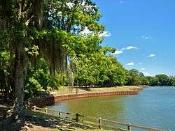 Roods Landing Site |
August 19, 1975 (#75000609) |
S of Omaha at confluence of Rood Creek and the Chattahoochee River 32°01′40″N 85°02′37″W |
Omaha | |
| 20 | Second Methodist Church | June 29, 1982 (#82002477) |
Mulberry St. 32°02′49″N 84°47′37″W |
Lumpkin | ||
| 21 | Singer-Moye Archeological Site | August 1, 1975 (#75000608) |
Address Restricted |
Lumpkin | ||
| 22 | Smith-Alston House | June 20, 1980 (#80001235) |
405 Ponder St. 32°05′38″N 84°39′42″W |
Richland | ||
| 23 | Stewart County Courthouse | 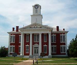 Stewart County Courthouse |
September 18, 1980 (#80001234) |
Courthouse Sq. 32°03′01″N 84°47′40″W |
Lumpkin | |
| 24 | John A. Tucker House | June 29, 1982 (#82002478) |
Florence St. 32°03′10″N 84°47′47″W |
Lumpkin | ||
| 25 | Uptown Residential Historic District | 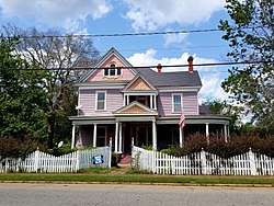 Uptown Residential Historic District |
June 29, 1982 (#82002479) |
Broad and Main Sts. 32°03′06″N 84°47′52″W |
Lumpkin | |
| 26 | Usher House | %3B_Lumpkin%2C_GA.JPG) Usher House |
June 29, 1982 (#82002480) |
Florence St. 32°03′08″N 84°48′04″W |
Lumpkin | Built c. 1836 |
| 27 | West Hill |  West Hill |
September 18, 1978 (#78001006) |
S of Lumpkin on U.S. 27 32°00′20″N 84°47′53″W |
Lumpkin |
gollark: You're the first person to bring this up, so I'm going to assume it's probably fine.
gollark: https://0t.lt/
gollark: Mine is shorterer.
gollark: 90% of crimes are committed by right-handed people.
gollark: Something something base rate fallacy.
References
- "National Register of Historic Places: Weekly List Actions". National Park Service, United States Department of the Interior. Retrieved on August 14, 2020.
- Numbers represent an ordering by significant words. Various colorings, defined here, differentiate National Historic Landmarks and historic districts from other NRHP buildings, structures, sites or objects.
- The eight-digit number below each date is the number assigned to each location in the National Register Information System database, which can be viewed by clicking the number.
| Wikimedia Commons has media related to National Register of Historic Places in Stewart County, Georgia. |
This article is issued from Wikipedia. The text is licensed under Creative Commons - Attribution - Sharealike. Additional terms may apply for the media files.