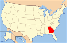
National Register of Historic Places listings in Floyd County, Georgia
This is a list of properties and districts in Floyd County, Georgia that are listed on the National Register of Historic Places (NRHP).
- This National Park Service list is complete through NPS recent listings posted August 14, 2020.[1]
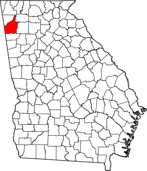
Location of Floyd County in Georgia
Current listings
| [2] | Name on the Register | Image | Date listed[3] | Location | City or town | Description |
|---|---|---|---|---|---|---|
| 1 | Dr. Robert Battey House | 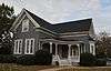 Dr. Robert Battey House |
June 17, 1982 (#82002414) |
725 E. 2nd Ave. 34°14′35″N 85°09′54″W |
Rome | |
| 2 | Berry Schools | 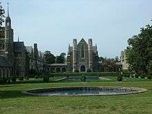 Berry Schools |
July 21, 1978 (#78000981) |
N of Rome on U.S. 27 34°18′27″N 85°12′49″W |
Rome | |
| 3 | Between the Rivers Historic District | 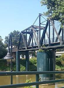 Between the Rivers Historic District |
June 9, 1983 (#83000193) |
Roughly bounded by the Etowah and Oostanaula Rivers, and 7th Ave. 34°15′06″N 85°10′16″W |
Rome | Historic district with more than 200 buildings, plus the Rome Clock Tower and a historic bridge. |
| 4 | John M. Carroll House | June 19, 1980 (#80001021) |
Park St. 34°06′09″N 85°20′23″W |
Cave Spring | ||
| 5 | Carroll-Harper House | June 19, 1980 (#80001023) |
Cedartown St. 34°06′13″N 85°20′10″W |
Cave Spring | ||
| 6 | Carroll-Richardson Grist Mill | June 19, 1980 (#80001025) |
Mill St. 34°06′04″N 85°20′27″W |
Cave Spring | ||
| 7 | Cave Spring Commercial Historic District |  Cave Spring Commercial Historic District |
June 19, 1980 (#80001028) |
Alabama, Rome and Cedartown Rds., Broad and Padlock Sts. 34°06′27″N 85°20′11″W |
Cave Spring | |
| 8 | Cave Spring Female Academy | June 19, 1980 (#80001030) |
Rome St. 34°06′43″N 85°19′59″W |
Cave Spring | ||
| 9 | Cave Spring High School | June 19, 1980 (#80001032) |
Rome St. 34°06′37″N 85°20′07″W |
Cave Spring | ||
| 10 | Cave Spring Railroad Station |  Cave Spring Railroad Station |
June 19, 1980 (#80001034) |
Alabama St. 34°06′28″N 85°20′32″W |
Cave Spring | |
| 11 | Cave Spring Residential Historic District | June 19, 1980 (#80001035) |
U.S. 411 and GA 100 34°06′29″N 85°20′22″W |
Cave Spring | ||
| 12 | Chieftains | 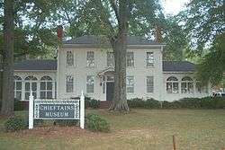 Chieftains |
April 7, 1971 (#71000273) |
80 Chatillon Rd. 34°16′38″N 85°10′13″W |
Rome | National Historic Landmark |
| 13 | Chubb Methodist Episcopal Church | 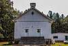 Chubb Methodist Episcopal Church |
May 4, 1990 (#90000728) |
Chubbtown Rd. 34°05′12″N 85°16′59″W |
Cave Spring | |
| 14 | Wesley O. Conner House | June 19, 1980 (#80001037) |
Cedartown St. 34°06′00″N 85°19′51″W |
Cave Spring | ||
| 15 | William D. Cowdry Plantation | June 19, 1980 (#80001039) |
Rome Rd. 34°07′01″N 85°20′10″W |
Cave Spring | ||
| 16 | Double-Cola Bottling Company | 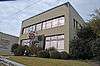 Double-Cola Bottling Company |
August 30, 2006 (#06000738) |
419 E. Second Ave. 34°14′52″N 85°10′10″W |
Rome | |
| 17 | East Rome Historic District | July 25, 1985 (#85001637) |
Roughly bounded by Walnut Ave., McCall Blvd., E. 8th and 10th Sts. 34°14′30″N 85°09′53″W |
Rome | ||
| 18 | Etowah Mounds | 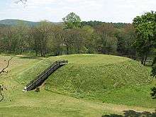 Etowah Mounds |
October 15, 1966 (#66000272) |
N bank of Etowah River 34°07′33″N 84°48′29″W |
Rome | |
| 19 | Fairview School | 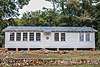 Fairview School |
June 5, 2017 (#100001019) |
276 Padlock Mountain Rd., SW. 34°06′06″N 85°18′53″W |
Cave Spring | |
| 20 | Oliver P. Fannin House | June 19, 1980 (#80001041) |
Cedartown St. 34°06′16″N 85°20′13″W |
Cave Spring | ||
| 21 | Floyd County Courthouse | 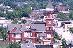 Floyd County Courthouse |
September 18, 1980 (#80001067) |
5th Ave., and Tribune St. 34°15′22″N 85°10′17″W |
Rome | |
| 22 | Joseph Ford House | June 19, 1980 (#80001043) |
Love and Alabama Sts. 34°06′23″N 85°20′12″W |
Cave Spring | ||
| 23 | Georgia School for the Deaf Historic District |  Georgia School for the Deaf Historic District |
June 19, 1980 (#80001045) |
Padlock St. 34°06′27″N 85°20′00″W |
Cave Spring | |
| 24 | Jackson Hill Historic District |  Jackson Hill Historic District |
April 25, 1997 (#97000370) |
Jackson Hill, between GA 53 and the Oostanaula River 34°15′51″N 85°09′52″W |
Rome | |
| 25 | Lower Avenue A Historic District | September 1, 1983 (#83000194) |
Avenue A between N. 5th St. and Turner-McCall Blvd. 34°15′33″N 85°10′24″W |
Rome | ||
| 26 | Main High School | October 24, 2002 (#02001219) |
41 Washington Dr. 34°15′27″N 85°09′15″W |
Rome | ||
| 27 | John T. Mann House | June 19, 1980 (#80001047) |
Rivers St. 34°06′33″N 85°20′12″W |
Cave Spring | ||
| 28 | Mayo's Bar Lock and Dam | November 16, 1989 (#89002020) |
On the Coosa River, 8 mi. SW of Rome 34°12′02″N 85°15′21″W |
Rome | ||
| 29 | Dr. W. T. McKinney House | June 19, 1980 (#80001049) |
Cedartown St. 34°05′59″N 85°20′19″W |
Cave Spring | ||
| 30 | Mt. Aventine Historic District | August 18, 1983 (#83000195) |
Address Restricted |
Rome | ||
| 31 | Myrtle Hill Cemetery | 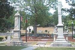 Myrtle Hill Cemetery |
September 1, 1983 (#83000196) |
Bounded by S. Broad, and Myrtle Sts., Pennington, and Branham Aves. 34°15′07″N 85°10′46″W |
Rome | |
| 32 | Oakdene Place | August 4, 1983 (#83000197) |
Roughly bounded by the Etowah River, Queen, and E. 6th Sts. 34°14′38″N 85°10′08″W |
Rome | ||
| 33 | Old Brick Mill | 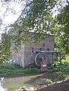 Old Brick Mill |
September 9, 1993 (#93000936) |
Park St. at Silver Cr. 34°11′19″N 85°10′28″W |
Lindale | |
| 34 | Rivers Farm | June 19, 1980 (#80001051) |
Rome St. 34°07′00″N 85°20′13″W |
Cave Spring | ||
| 35 | Samuel W. Robbins House | June 19, 1980 (#80001053) |
Rome St. 34°06′30″N 85°20′10″W |
Cave Spring | ||
| 36 | Rolator Park Historic District | June 19, 1980 (#80001055) |
Off U.S. 411 34°06′16″N 85°20′07″W |
Cave Spring | ||
| 37 | Rome Clock Tower | 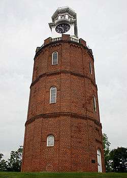 Rome Clock Tower |
February 8, 1980 (#80001068) |
Off GA 101 34°15′13″N 85°10′09″W |
Rome | |
| 38 | Roving House | June 19, 1980 (#80001057) |
Rome St. 34°06′39″N 85°19′49″W |
Cave Spring | ||
| 39 | Sardis Presbyterian Church and Cemetery | 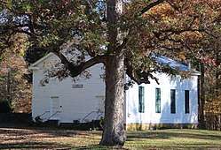 Sardis Presbyterian Church and Cemetery |
January 12, 2005 (#04001468) |
7104 GA 20 NW 34°15′55″N 85°22′41″W |
Coosa | |
| 40 | Simmons House | 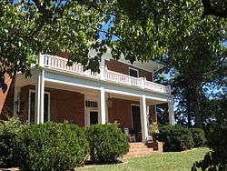 Simmons House |
June 19, 1980 (#80001059) |
Cedartown St. 34°05′57″N 85°19′59″W |
Cave Spring | |
| 41 | William S. Simmons Plantation | June 19, 1980 (#80001061) |
Alabama St. 34°06′03″N 85°20′41″W |
Cave Spring | ||
| 42 | South Broad Street Historic District | August 18, 1983 (#83004182) |
S. Broad St. and Etowah Terrace 34°14′57″N 85°10′40″W |
Rome | ||
| 43 | Sullivan-Hillyer House | 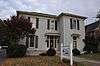 Sullivan-Hillyer House |
October 21, 2002 (#02001215) |
309 E. Second Ave. 34°15′00″N 85°10′17″W |
Rome | |
| 44 | Thankful Baptist Church | 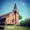 Thankful Baptist Church |
September 5, 1985 (#85001973) |
935 Spiderwebb Dr. 34°15′28″N 85°09′36″W |
Rome | |
| 45 | U.S. Post Office and Courthouse | 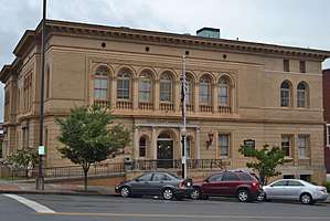 U.S. Post Office and Courthouse |
May 6, 1975 (#75000592) |
W. 4th Ave. and E. 1st St. 34°15′14″N 85°10′15″W |
Rome | |
| 46 | Upper Avenue A Historic District | September 1, 1983 (#83000198) |
Roughly bounded by Oostanaula River, Turner-McCall Blvd., Avenue B and W. 11th St. 34°15′45″N 85°10′27″W |
Rome | ||
| 47 | George T. Watts House | June 19, 1980 (#80001063) |
Love St. 34°06′22″N 85°20′24″W |
Cave Spring | ||
| 48 | Wharton-Trout House | June 19, 1980 (#80001065) |
Rome St. 34°06′53″N 85°19′44″W |
Cave Spring |
gollark: What? We use deep neural networks. Shallow ones are so last decade.
gollark: But there just aren't very many good low-power AI inference products.
gollark: Yes, yes, I know, it isn't ideal.
gollark: They're mostly designed for computer vision but you can run kit neural networks™ on them with hacks.
gollark: Yes, we run the "kit"/"aouwt" neural networks on these.
References
- "National Register of Historic Places: Weekly List Actions". National Park Service, United States Department of the Interior. Retrieved on August 14, 2020.
- Numbers represent an ordering by significant words. Various colorings, defined here, differentiate National Historic Landmarks and historic districts from other NRHP buildings, structures, sites or objects.
- The eight-digit number below each date is the number assigned to each location in the National Register Information System database, which can be viewed by clicking the number.
| Wikimedia Commons has media related to National Register of Historic Places in Floyd County, Georgia. |
| Topics | |
|---|---|
| Lists by state |
|
| Lists by insular areas | |
| Lists by associated state | |
| Other areas | |
| Related | |
| |
This article is issued from Wikipedia. The text is licensed under Creative Commons - Attribution - Sharealike. Additional terms may apply for the media files.