National Register of Historic Places listings in Hart County, Georgia
This is a list of properties and districts in Hart County, Georgia that are listed on the National Register of Historic Places (NRHP).
- This National Park Service list is complete through NPS recent listings posted August 14, 2020.[1]
Current listings
| [2] | Name on the Register | Image | Date listed[3] | Location | City or town | Description |
|---|---|---|---|---|---|---|
| 1 | Adams-Matheson House | 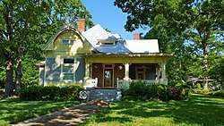 Adams-Matheson House |
September 11, 1986 (#86002003) |
116 Athens St. 34°21′06″N 82°56′27″W |
Hartwell | |
| 2 | Archibald Mewborn House | January 9, 1997 (#96001556) |
Approximately 1 mi. E of GA 172, 7 mi. S of Hartwell 34°14′43″N 82°57′26″W |
Hartwell | ||
| 3 | Benson Street-Forest Avenue Residential Historic District |  Benson Street-Forest Avenue Residential Historic District |
September 11, 1986 (#86002004) |
Roughly along Benson St. from Forest Ave. to Adams St. and along Forest Ave. from Railroad St. to Garrison Rd. 34°20′52″N 82°55′52″W |
Hartwell | |
| 4 | Allie M. Best House | 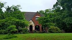 Allie M. Best House |
September 11, 1986 (#86002005) |
122 Athens St. 34°21′02″N 82°56′30″W |
Hartwell | |
| 5 | Bowersville Historic District | 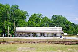 Bowersville Historic District |
September 5, 1985 (#85001975) |
E. and W. Main St. 34°22′22″N 83°05′00″W |
Bowersville | |
| 6 | Chandler-Linder House |  Chandler-Linder House |
September 11, 1986 (#86002006) |
Johnson St. 34°21′19″N 82°56′07″W |
Hartwell | |
| 7 | H. E. Fortson House | 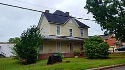 H. E. Fortson House |
September 11, 1986 (#86002007) |
221 Richardson St. 34°21′30″N 82°55′42″W |
Hartwell | |
| 8 | Franklin Light and Power Company Steam Generating Station | September 11, 1986 (#86002009) |
Leard St. at RR track 34°21′20″N 82°56′46″W |
Hartwell | ||
| 9 | Franklin Street-College Avenue Residential Historic District |  Franklin Street-College Avenue Residential Historic District |
September 11, 1986 (#86002011) |
Roughly bounded by Johnson, Maple, Franklin and First, and Carter Sts. 34°21′09″N 82°55′42″W |
Hartwell | |
| 10 | Gulley-Gurley Farm | April 17, 1997 (#97000334) |
1389 Lou Gurley Road 34°23′54″N 83°02′11″W |
Bowersville | ||
| 11 | Gulley-Vickery-Blackwell House | September 11, 1986 (#86002014) |
115 Franklin St. 34°21′13″N 82°55′56″W |
Hartwell | ||
| 12 | Hart County Jail |  Hart County Jail |
September 13, 1985 (#85002085) |
Johnson St. 34°21′17″N 82°56′00″W |
Hartwell | |
| 13 | Hartwell City School |  Hartwell City School |
September 11, 1986 (#86002016) |
College Ave. 34°20′58″N 82°55′44″W |
Hartwell | |
| 14 | Hartwell Commercial Historic District |  Hartwell Commercial Historic District |
September 11, 1986 (#86002019) |
Roughly bounded by Franklin St., Forest Ave., Railroad St., and Jackson and Carolina Sts. 34°21′07″N 82°56′00″W |
Hartwell | |
| 15 | Hartwell Methodist Episcopal Church, South |  Hartwell Methodist Episcopal Church, South |
September 11, 1986 (#86002021) |
Howell St. 34°21′10″N 82°56′09″W |
Hartwell | |
| 16 | Horton-Vickery House |  Horton-Vickery House |
September 11, 1986 (#86002024) |
101 Vickery St. 34°21′28″N 82°55′51″W |
Hartwell | |
| 17 | Pearl J. Jones House | 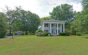 Pearl J. Jones House |
September 11, 1986 (#86002027) |
401 Athens St. 34°20′43″N 82°56′37″W |
Hartwell | |
| 18 | Kendrick-Matheson House |  Kendrick-Matheson House |
September 11, 1986 (#86002029) |
212 Athens St. 34°20′55″N 82°56′32″W |
Hartwell | |
| 19 | Charles I. Kidd House | 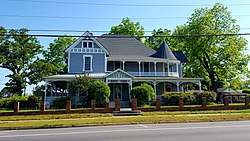 Charles I. Kidd House |
September 11, 1986 (#86002032) |
304 W. Howell St. 34°21′12″N 82°56′11″W |
Hartwell | |
| 20 | Roscoe Conklin Linder House | 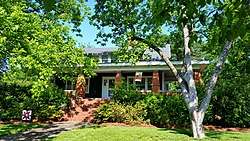 Roscoe Conklin Linder House |
September 11, 1986 (#86002033) |
118 Athens St. 34°21′05″N 82°56′28″W |
Hartwell | |
| 21 | McCurry-Kidd House | 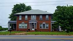 McCurry-Kidd House |
September 11, 1986 (#86002035) |
602 W. Howell St. 34°21′17″N 82°56′22″W |
Hartwell | Two-story brick Georgian Revival-style house from c.1920, believed to be the only Georgian Revival house in Hartwell. |
| 22 | McMullan-Vickery Farm |  McMullan-Vickery Farm |
September 11, 1986 (#86002037) |
602 Forest Ave. 34°21′39″N 82°55′45″W |
Hartwell | |
| 23 | Dr. Owen Meredith House |  Dr. Owen Meredith House |
September 11, 1986 (#86002040) |
605 Benson St. 34°20′42″N 82°55′32″W |
Hartwell | |
| 24 | Jackson Morrison House | September 11, 1986 (#86002046) |
439 Rome St. 34°21′44″N 82°55′29″W |
Hartwell | ||
| 25 | Patterson-Turner Homeplace | July 26, 1990 (#90001126) |
Smith-McGee Bridge Rd. 34°21′16″N 82°54′27″W |
Hartwell | ||
| 26 | Pure Oil Service Station | 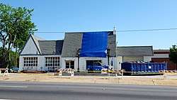 Pure Oil Service Station |
September 11, 1986 (#86002047) |
Howell St. at Jackson St. 34°21′10″N 82°56′03″W |
Hartwell | |
| 27 | Emory Edward Satterfield House |  Emory Edward Satterfield House |
September 11, 1986 (#86002049) |
504 W. Howell St. 34°21′15″N 82°56′19″W |
Hartwell | |
| 28 | Meyer Saul House | September 11, 1986 (#86002043) |
304 W. Johnson St. 34°21′19″N 82°56′09″W |
Hartwell | ||
| 29 | Alexander Stephens Skelton House |  Alexander Stephens Skelton House |
September 11, 1986 (#86002050) |
214 Athens St. 34°20′55″N 82°56′33″W |
Hartwell | |
| 30 | Ralph Teasley House |  Ralph Teasley House |
September 11, 1986 (#86002053) |
421 W. Howell St. 34°21′12″N 82°56′19″W |
Hartwell | |
| 31 | Thomas William Teasley House |  Thomas William Teasley House |
September 11, 1986 (#86002055) |
417 W. Howell St. 34°21′12″N 82°56′17″W |
Hartwell | |
| 32 | Teasley-Holland House |  Teasley-Holland House |
September 11, 1986 (#86002052) |
416 W. Howell St. 34°21′14″N 82°56′17″W |
Hartwell | |
| 33 | John Roland Temple House |  John Roland Temple House |
September 11, 1986 (#86002059) |
129 Athens St. 34°21′00″N 82°56′29″W |
Hartwell | |
| 34 | Temple-Skelton House |  Temple-Skelton House |
September 11, 1986 (#86002057) |
201 Athens St. 34°20′58″N 82°56′29″W |
Hartwell | |
| 35 | John Underwood House | September 11, 1986 (#86002062) |
825 S. Jackson St. 34°20′33″N 82°56′22″W |
Hartwell | ||
| 36 | Witham Cotton Mills Village Historic District |  Witham Cotton Mills Village Historic District |
September 11, 1986 (#86002064) |
Along Liberty Circle, Jackson, and Webb Sts. 34°21′00″N 82°56′10″W |
Hartwell |
gollark: I doubt they could just fake clinical trials somehow and get all the regulators to go along with it.
gollark: The reason I think the assumption isn't great is that people see each other in multiple gatherings and so one person being infected means others are more likely to be and vice versa
gollark: It replicates what <@215706991748841473>'s code does. Also, I'm not sure exactly what you're saying.
gollark: (the code makes the same simplifying assumption anyway)
gollark: I'm pretty sure that (assuming the probability of each person at the gathering having COVID-19 is independent and just equal to the fraction of the population which us infected, which is not true but important to simplify) the number of people at the gathering who have it follows the binomial distribution.
References
- "National Register of Historic Places: Weekly List Actions". National Park Service, United States Department of the Interior. Retrieved on August 14, 2020.
- Numbers represent an ordering by significant words. Various colorings, defined here, differentiate National Historic Landmarks and historic districts from other NRHP buildings, structures, sites or objects.
- The eight-digit number below each date is the number assigned to each location in the National Register Information System database, which can be viewed by clicking the number.
| Wikimedia Commons has media related to National Register of Historic Places in Hart County, Georgia. |
This article is issued from Wikipedia. The text is licensed under Creative Commons - Attribution - Sharealike. Additional terms may apply for the media files.