National Register of Historic Places listings in Lumpkin County, Georgia
This is a list of properties and districts in Lumpkin County, Georgia that are listed on the National Register of Historic Places (NRHP).
- This National Park Service list is complete through NPS recent listings posted August 14, 2020.[1]
Current listings
| [2] | Name on the Register | Image | Date listed[3] | Location | City or town | Description |
|---|---|---|---|---|---|---|
| 1 | Blood Mountain Trail Shelter | 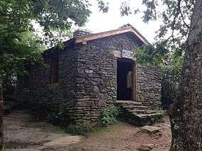 Blood Mountain Trail Shelter |
January 9, 2013 (#12001145) |
Blood Mountain Wilderness Area 34°44′25″N 83°56′15″W |
Blairsville | |
| 2 | Calhoun Mine | 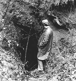 Calhoun Mine |
November 7, 1973 (#73002292) |
3 miles (4.8 km) south of Dahlonega off GA 60 34°33′43″N 83°59′09″W |
Dahlonega | National Historic Landmark |
| 3 | Dahlonega Commercial Historic District | 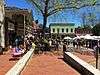 Dahlonega Commercial Historic District |
April 7, 1983 (#83000235) |
Chestates, Park, and Main Sts. 34°31′57″N 83°59′05″W |
Dahlonega | |
| 4 | Dahlonega Consolidated Gold Mine | .JPG) Dahlonega Consolidated Gold Mine |
February 27, 1980 (#80001111) |
Northeast of Dahlonega 34°32′18″N 83°58′12″W |
Dahlonega | |
| 5 | Dahlonega Courthouse Gold Museum | 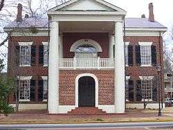 Dahlonega Courthouse Gold Museum |
August 26, 1971 (#71001100) |
U.S. 19 34°31′57″N 83°59′06″W |
Dahlonega | A Georgia state historic site |
| 6 | Daniel M. Davis House | .JPG) Daniel M. Davis House |
March 12, 1998 (#98000227) |
GA 9, 1.5 miles (2.4 km) southwest of the junction with GA 52 34°30′49″N 84°03′51″W |
Dahlonega | |
| 7 | Fields Place-Vickery House | 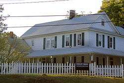 Fields Place-Vickery House |
December 14, 1978 (#78000994) |
W. Main St. and Vickery Dr. 34°31′49″N 83°59′17″W |
Dahlonega | |
| 8 | Hawkins Street Historic District | May 12, 1995 (#95000504) |
Roughly, Hawkins St. from Church St. to N. Meaders St., including adjacent parts of Water, N. Chestatee and N. Park Sts. 34°32′00″N 83°59′11″W |
Dahlonega | ||
| 9 | Holly Theatre | 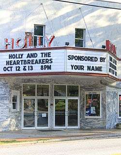 Holly Theatre |
February 21, 2002 (#02000080) |
69 W. Main St. 34°31′53″N 83°59′09″W |
Dahlonega | |
| 10 | Lumpkin County Jail | 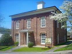 Lumpkin County Jail |
September 13, 1985 (#85002086) |
Clarksville St. 34°32′03″N 83°58′54″W |
Dahlonega | |
| 11 | Price Memorial Hall | 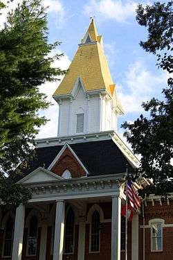 Price Memorial Hall |
January 20, 1972 (#72000387) |
College Ave. 34°31′47″N 83°59′13″W |
Dahlonega | |
| 12 | Seven Oaks |  Seven Oaks |
July 15, 1982 (#82002452) |
177 S. Park St. 34°31′51″N 83°58′56″W |
Dahlonega |
gollark: Odd.
gollark: ++magic reload_ext irc_link
gollark: ++help
gollark: ++magic reload_ext irc_link
gollark: It's not like blocking people individually is particularly bad.
References
- "National Register of Historic Places: Weekly List Actions". National Park Service, United States Department of the Interior. Retrieved on August 14, 2020.
- Numbers represent an ordering by significant words. Various colorings, defined here, differentiate National Historic Landmarks and historic districts from other NRHP buildings, structures, sites or objects.
- The eight-digit number below each date is the number assigned to each location in the National Register Information System database, which can be viewed by clicking the number.
| Wikimedia Commons has media related to National Register of Historic Places in Lumpkin County, Georgia. |
| Topics | |
|---|---|
| Lists by state |
|
| Lists by insular areas | |
| Lists by associated state | |
| Other areas | |
| Related | |
| |
This article is issued from Wikipedia. The text is licensed under Creative Commons - Attribution - Sharealike. Additional terms may apply for the media files.