National Register of Historic Places listings in Clarke County, Georgia
This is a list of properties and districts in Clarke County, Georgia that are listed on the National Register of Historic Places (NRHP).
- This National Park Service list is complete through NPS recent listings posted August 14, 2020.[1]
Current listings
| [2] | Name on the Register | Image | Date listed[3] | Location | City or town | Description |
|---|---|---|---|---|---|---|
| 1 | Athens Factory |  Athens Factory |
July 31, 1980 (#80000989) |
Baldwin and Williams Sts. 33°57′10″N 83°22′10″W |
Athens | |
| 2 | Athens Manufacturing Company |  Athens Manufacturing Company |
December 31, 2002 (#02001634) |
585 While Circle 33°54′20″N 83°21′28″W |
Athens | |
| 3 | Athens Warehouse Historic District |  Athens Warehouse Historic District |
October 20, 1988 (#88002021) |
Roughly bounded by Hancock and Thomas Sts., and the RR tracks 33°57′32″N 83°22′17″W |
Athens | |
| 4 | Bishop House |  Bishop House |
March 16, 1972 (#72000375) |
Jackson St., University of Georgia campus 33°57′21″N 83°22′23″W |
Athens | |
| 5 | Bloomfield Street Historic District |  Bloomfield Street Historic District |
April 18, 1985 (#85000850) |
Roughly bounded by Bloomfield and Peabody Sts., U of G campus, Rutherford St and Milledge Ave. 33°56′44″N 83°23′06″W |
Athens | |
| 6 | Boulevard Historic District |  Boulevard Historic District |
April 18, 1985 (#85000851) |
Roughly bounded by the Seaboard Coastline RR tracks, Pulaski St., Prince Ave., and Hiawassee St. 33°57′54″N 83°23′23″W |
Athens | |
| 7 | Brightwell Shotgun Row |  Brightwell Shotgun Row |
June 14, 2001 (#01000642) |
366-376 Barber St. 33°57′59″N 83°23′08″W |
Athens | |
| 8 | Buena Vista Heights Historic District |  Buena Vista Heights Historic District |
August 27, 1999 (#99001029) |
Roughly bounded by Park Ave., Prince Ave., Pound St., and Nantahala Extension 33°57′58″N 83°24′06″W |
Athens | |
| 9 | Camak House | .jpg) Camak House |
July 7, 1975 (#75000576) |
279 Meigs St. 33°57′32″N 83°22′59″W |
Athens | |
| 10 | Carnegie Library Building | 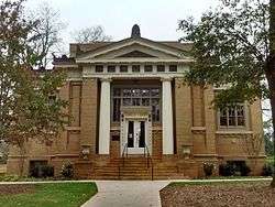 Carnegie Library Building |
November 11, 1975 (#75000577) |
1401 Prince Ave. 33°57′50″N 83°24′16″W |
Athens | |
| 11 | Albon Chase House | 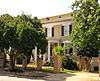 Albon Chase House |
August 19, 1974 (#74002255) |
185 N. Hull St. 33°57′27″N 83°22′45″W |
Athens | |
| 12 | Chestnut Grove School | 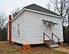 Chestnut Grove School |
June 28, 1984 (#84003873) |
610 Epps Bridge Rd. 33°55′59″N 83°26′18″W |
Athens | |
| 13 | Chi Omega House | July 11, 2019 (#100003491) |
324 S. Milledge Ave. 33°57′09″N 83°23′16″W |
Athens | ||
| 14 | Church-Waddel-Brumby House | 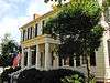 Church-Waddel-Brumby House |
February 20, 1975 (#75000578) |
280 E. Dougherty St. 33°57′43″N 83°22′33″W |
Athens | |
| 15 | Clarke County Jail |  Clarke County Jail |
May 29, 1980 (#80000990) |
Courthouse Sq. 33°57′34″N 83°23′06″W |
Athens | |
| 16 | T. R. R. Cobb House | .jpg) T. R. R. Cobb House |
June 30, 1975 (#75000579) |
194 Prince Ave. 33°57′40″N 83°22′54″W |
Athens | De-listed in 1985, but re-listed on July 23, 2013[4] |
| 17 | Cobb-Treanor House |  Cobb-Treanor House |
May 8, 1979 (#79000705) |
1234 S. Lumpkin St. 33°56′42″N 83°22′46″W |
Athens | |
| 18 | Cobbham Historic District |  Cobbham Historic District |
August 24, 1978 (#78000973) |
Roughly bounded by Prince Ave., Hill, Reese, and Pope Sts. 33°57′32″N 83°23′31″W |
Athens | |
| 19 | Coca-Cola Bottling Plant-Athens |  Coca-Cola Bottling Plant-Athens |
February 1, 2006 (#05001594) |
297 Prince Ave. 33°57′35″N 83°23′00″W |
Athens | |
| 20 | Ross Crane House |  Ross Crane House |
June 18, 1979 (#79000706) |
247 Pulaski St. 33°57′30″N 83°22′51″W |
Athens | |
| 21 | Dearing Street Historic District | _197_Dearing_Street_1859.JPG) Dearing Street Historic District |
September 5, 1975 (#75000580) |
Roughly bounded by Broad and Baxter Sts., Milledge Ave., and includes both sides of Finley St. and Henderson Ave. 33°57′11″N 83°23′07″W |
Athens | includes the Tree That Owns Itself |
| 22 | Albin P. Dearing House | .jpg) Albin P. Dearing House |
May 8, 1979 (#79000707) |
338 S. Milledge Ave. 33°57′06″N 83°23′16″W |
Athens | |
| 23 | Downtown Athens Historic District |  Downtown Athens Historic District |
August 10, 1978 (#78000974) |
Roughly bounded by Hancock Ave., Foundry, Mitchell 33°57′30″N 83°22′25″W |
Athens | There was a boundary increase on May 31, 1984 (refnum 84000965), and a boundary increase and decrease on August 18, 2006 (refnum 06000737) |
| 24 | First African Methodist Episcopal Church |  First African Methodist Episcopal Church |
March 10, 1980 (#80000991) |
521 N. Hull St. 33°57′39″N 83°22′46″W |
Athens | |
| 25 | Franklin House | _1936_Historic_American_Buildings_Survey.jpg) Franklin House |
December 11, 1974 (#74000667) |
464-480 E. Broad St. 33°57′28″N 83°22′35″W |
Athens | |
| 26 | Garden Club of Georgia Museum-Headquarters House, Founder's Memorial Garden |  Garden Club of Georgia Museum-Headquarters House, Founder's Memorial Garden |
April 26, 1972 (#72000376) |
Lumpkin St., University of Georgia campus 33°57′15″N 83°22′33″W |
Athens | |
| 27 | Gospel Pilgrim Cemetery | 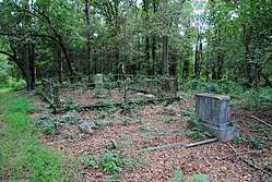 Gospel Pilgrim Cemetery |
April 19, 2006 (#06000285) |
530 Fourth St. 33°58′09″N 83°21′41″W |
Athens | |
| 28 | Henry W. Grady House | .jpg) Henry W. Grady House |
May 11, 1976 (#76000613) |
634 Prince Ave. 33°57′42″N 83°23′18″W |
Athens | National Historic Landmark |
| 29 | Dr. James S. Hamilton House | .JPG) Dr. James S. Hamilton House |
April 24, 1979 (#79000708) |
150 S. Milledge Ave. 33°57′16″N 83°23′19″W |
Athens | |
| 30 | Jackson Street Cemetery | 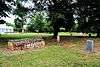 Jackson Street Cemetery |
October 2, 2009 (#09000779) |
S. Jackson St., University of Georgia campus 33°57′21″N 83°22′25″W |
Athens | |
| 31 | Lucy Cobb Institute Campus | 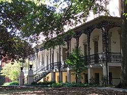 Lucy Cobb Institute Campus |
March 16, 1972 (#72000377) |
200 N. Milledge Ave., University of Georgia campus 33°57′22″N 83°23′23″W |
Athens | |
| 32 | Gov. Wilson Lumpkin House | 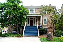 Gov. Wilson Lumpkin House |
March 16, 1972 (#72000378) |
Cedar St., University of Georgia campus 33°56′51″N 83°22′26″W |
Athens | |
| 33 | Joseph Henry Lumpkin House | .jpg) Joseph Henry Lumpkin House |
June 27, 1975 (#75000581) |
248 Prince Ave. 33°57′38″N 83°22′57″W |
Athens | |
| 34 | Milledge Avenue Historic District | 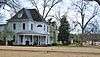 Milledge Avenue Historic District |
April 18, 1985 (#85000852) |
Milledge Ave. from Broad St. to Five Points 33°56′52″N 83°23′16″W |
Athens | Boundary increase (listed September 24, 2009): 295 W. Rutherford St. |
| 35 | Milledge Circle Historic District | .JPG) Milledge Circle Historic District |
April 18, 1985 (#85000859) |
Milledge Park, Lumpkin St., Milledge Circle and Milledge Ave. 33°56′15″N 83°23′22″W |
Athens | |
| 36 | Morton Building | 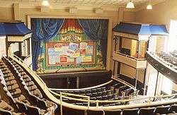 Morton Building |
October 22, 1979 (#79000709) |
199 W. Washington St. 33°57′31″N 83°22′43″W |
Athens | |
| 37 | Newton House | 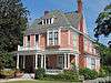 Newton House |
July 11, 2002 (#02000759) |
892 Prince Ave. 33°57′43″N 83°23′34″W |
Athens | |
| 38 | Oconee Hill Cemetery | 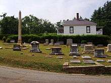 Oconee Hill Cemetery |
May 22, 2013 (#13000291) |
297 Cemetery St. 33°57′04″N 83°22′06″W |
Athens | |
| 39 | Oconee Street School | December 31, 2018 (#100003284) |
594 Oconee St. 33°57′09″N 83°21′59″W |
Athens | ||
| 40 | Oglethorpe Avenue Historic District |  Oglethorpe Avenue Historic District |
November 5, 1987 (#87001360) |
Oglethorpe Ave. 33°57′58″N 83°24′15″W |
Athens | |
| 41 | Old North Campus, University of Georgia |  Old North Campus, University of Georgia |
March 16, 1972 (#72000379) |
Bounded by Broad, Lumpkin, and Jackson Sts. 33°58′01″N 83°22′30″W |
Athens | |
| 42 | Hubert Bond Owens House | .JPG) Hubert Bond Owens House |
May 14, 2008 (#08000442) |
215 W. Rutherford St. 33°56′34″N 83°23′10″W |
Athens | |
| 43 | Calvin W. Parr House | .JPG) Calvin W. Parr House |
September 9, 1982 (#82002394) |
227 Bloomfield St. 33°56′53″N 83°23′09″W |
Athens | |
| 44 | Parrott Insurance Building |  Parrott Insurance Building |
October 7, 1977 (#77000416) |
283 E. Broad St. 33°57′28″N 83°22′30″W |
Athens | |
| 45 | President's House |  President's House |
March 16, 1972 (#72000380) |
570 Prince Ave. 33°57′41″N 83°23′11″W |
Athens | |
| 46 | Reese Street Historic District | 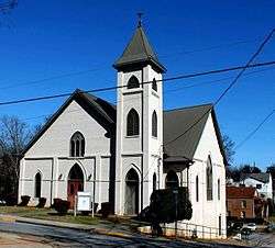 Reese Street Historic District |
November 10, 1987 (#87001990) |
Roughly bounded by Meigs, Finley, Broad, & Harris Sts. 33°57′26″N 83°23′06″W |
Athens | Includes the Hill First Baptist Church. |
| 47 | Rocksprings Shotgun Row Historic District | .JPG) Rocksprings Shotgun Row Historic District |
August 23, 1996 (#96000875) |
433-447 Rocksprings St. 33°56′50″N 83°23′29″W |
Athens | |
| 48 | James A. Sledge House | .jpg) James A. Sledge House |
February 12, 1974 (#74000668) |
749 Cobb St. 33°57′37″N 83°23′49″W |
Athens | |
| 49 | R. P. Sorrells House | 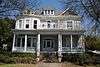 R. P. Sorrells House |
January 22, 1992 (#91002003) |
220 Prince Ave. 33°57′38″N 83°22′56″W |
Athens | |
| 50 | Thomas-Carithers House | 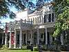 Thomas-Carithers House |
May 8, 1979 (#79000710) |
530 S. Milledge Ave. 33°56′56″N 83°23′16″W |
Athens | |
| 51 | Upson House |  Upson House |
November 15, 1973 (#73000616) |
1022 Prince Ave. 33°57′14″N 83°23′40″W |
Athens | |
| 52 | United States Post Office and Courthouse | 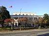 United States Post Office and Courthouse |
September 10, 2014 (#14000554) |
115 E. Hancock St. 33°57′36″N 83°22′38″W |
Athens | |
| 53 | Ware-Lyndon House |  Ware-Lyndon House |
March 15, 1976 (#76000614) |
293 Hoyt St. 33°57′50″N 83°22′35″W |
Athens | |
| 54 | West Cloverhurst Avenue Historic District |  West Cloverhurst Avenue Historic District |
September 27, 2007 (#07001000) |
W. Cloverhurst Ave. vet. Springdale St. and S. Milledge Ave. 33°56′39″N 83°23′30″W |
Athens | |
| 55 | West Hancock Avenue Historic District |  West Hancock Avenue Historic District |
March 30, 1988 (#88000227) |
Roughly bounded by Hill, Franklin, Broad Sts. and the Plaza 33°57′20″N 83°23′38″W |
Athens | |
| 56 | White Hall | .JPG) White Hall |
June 18, 1979 (#79000711) |
Whitehall and Simonton Bridge Rds. 33°53′48″N 83°21′50″W |
Whitehall | |
| 57 | Wilkins House |  Wilkins House |
May 19, 1970 (#70000202) |
387 S. Milledge Ave. 33°57′04″N 83°23′12″W |
Athens | |
| 58 | Winterville Historic District | 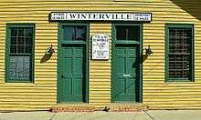 Winterville Historic District |
October 11, 2001 (#01000742) |
Roughly center on Main St. and on the abandoned Georgia RR line within the city limits of Winterville 33°58′03″N 83°16′40″W |
Winterville | |
| 59 | Woodlawn Historic District | 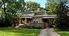 Woodlawn Historic District |
October 23, 1987 (#87001390) |
Woodlawn Ave. 33°56′31″N 83°22′53″W |
Athens | |
| 60 | Young Women's Christian Association Complex | 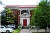 Young Women's Christian Association Complex |
May 12, 1987 (#87000696) |
345-347 W. Hancock St. 33°57′31″N 83°22′51″W |
Athens |
gollark: For backend stuff general purpose programming languages like Python which are less awful are preferred.
gollark: ÆÆÆÆÆÆÆÆ please do not use PHP.
gollark: Still, lifetime doesn't mean forever, just however long the service actually exists.
gollark: It was on sale quite cheaply a while back but I missed it.
gollark: It seemed to work well, but he never did get any servers with activity to not ban/kick him soon after arrival.
References
- "National Register of Historic Places: Weekly List Actions". National Park Service, United States Department of the Interior. Retrieved on August 14, 2020.
- Numbers represent an ordering by significant words. Various colorings, defined here, differentiate National Historic Landmarks and historic districts from other NRHP buildings, structures, sites or objects.
- The eight-digit number below each date is the number assigned to each location in the National Register Information System database, which can be viewed by clicking the number.
- "Cobb, T. R. R., House". National Register of Historic Places Program. National Park Service. Retrieved August 26, 2013.
| Wikimedia Commons has media related to National Register of Historic Places in Clarke County, Georgia. |
| Topics | |
|---|---|
| Lists by state |
|
| Lists by insular areas | |
| Lists by associated state | |
| Other areas | |
| Related | |
| |
This article is issued from Wikipedia. The text is licensed under Creative Commons - Attribution - Sharealike. Additional terms may apply for the media files.