Cape Conway
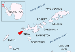
Cape Conway is the rounded low and ice-free tipped cape forming the south extremity of Snow Island in the South Shetland Islands, Antarctica. It is a south entrance point for Boyd Strait. Tooth Rock (62°51′32.4″S 61°25′33.9″W) rising to 85 m (279 ft) and lying 1.94 km (1.21 mi) to the south is the largest in a group of rocks extending 2.7 km (1.7 mi) from the cape. The area was visited by 19th century sealers.
 Location of Cape Conway | |
 Cape Conway  Cape Conway | |
| Geography | |
|---|---|
| Location | Antarctica |
| Coordinates | 62°50′30″S 61°25′43″W |
| Archipelago | South Shetland Islands |
| Administration | |
| Administered under the Antarctic Treaty System | |
| Demographics | |
| Population | uninhabited |
Cape Conway was charted in 1829 by the British naval expedition under Captain Henry Foster and named after HMS Conway in which Foster had previously served. Tooth Rock was descriptively named following a survey from RRS John Biscoe in 1951–52.
Location
The cape is located at 62°50′30″S 61°25′43″W which is 10.58 km (6.57 mi) south-southeast of Byewater Point, 17.3 km (10.7 mi) southwest of President Head, 11.75 km (7.30 mi) southwest of Hall Peninsula and 44.46 km (27.63 mi) east by north of Cape Smith, Smith Island (British mapping in 1821–22, 1935, 1951-51 and 1968, Argentine in 1946, Chilean in 1974, and Bulgarian in 2009).

See also
- Composite Antarctic Gazetteer
- List of Antarctic islands south of 60° S
- SCAR
- Territorial claims in Antarctica
Maps
- L.L. Ivanov. Antarctica: Livingston Island and Greenwich, Robert, Snow and Smith Islands. Scale 1:120000 topographic map. Troyan: Manfred Wörner Foundation, 2009. ISBN 978-954-92032-6-4