Aldermaston
Aldermaston /ˈɔːldərmɑːstən/ is a mostly rural, dispersed settlement, civil parish and electoral ward in Berkshire, England. In the United Kingdom Census 2011, the parish had a population of 1015.[2] The village is in the mid-Kennet alluvial plain and bounds to Hampshire in the south. It is roughly equidistant from Newbury, Basingstoke and Reading, centred 46 miles (74 km) west-by-south-west of London.
| Aldermaston | |
|---|---|
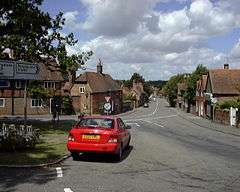 The Street, Aldermaston | |
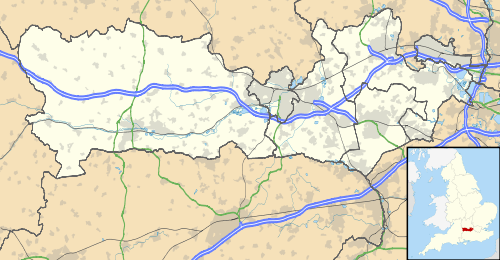 Aldermaston Location within Berkshire | |
| Area | 13.4 km2 (5.2 sq mi) |
| Population | 1,015 (2011 census)[1] |
| • Density | 76/km2 (200/sq mi) |
| OS grid reference | SU5965 |
| • London | 46 miles (74 km) |
| Civil parish |
|
| Unitary authority | |
| Ceremonial county | |
| Region | |
| Country | England |
| Sovereign state | United Kingdom |
| Post town | Reading |
| Postcode district | RG7 |
| Dialling code | 0118 |
| Police | Thames Valley |
| Fire | Royal Berkshire |
| Ambulance | South Central |
| UK Parliament | |
Aldermaston may have been inhabited as early as 1690 BCE; a number of postholes and remains of cereal grains have been found in the area. Written history of the village is traced back at least as far as the 9th century CE. The Anglo-Saxon Chronicles show that the Ealdorman of Berkshire had his country estate in the village. The manor of Aldermaston was established by the early 11th century, when the village was given to the Achard family by Henry I; the manor is documented in the Domesday survey. The village church was established in the 13th century, and some of the original Norman architecture remains in the building's structure. The last resident Lord of the Manor, Charles Keyser, died in 1929. The manor estate has been subsequently occupied by Associated Electrical Industries, the XIX Tactical Air Command, the Women's Land Army, Collier Macmillan Schools, Blue Circle Industries, and the Compass Group, who ran it as a hotel and corporate venue. It was bought by the Praxis Group in 2013 for £4.7 million and is now subject to plans for restoration that include 227 new homes in order to finance the restoration of the manor house and grounds.
The name "Aldermaston" is well known in connection with the UK's nuclear weapons programme, as well as the Campaign for Nuclear Disarmament. The Atomic Weapons Establishment (AWE), which develops, maintains, and disposes of the UK's nuclear weaponry is in the parish. Built on the site of the former RAF Aldermaston, the plant has been the destination of numerous Aldermaston Marches. Until 2006, the village was home to the Aldermaston Pottery, which was established by Alan Caiger-Smith and Geoffrey Eastop in 1955.
History
Evidence suggests that Aldermaston was inhabited in the 12th century CE, possibly extending back to 1690 BCE.[3] Radiocarbon dating on postholes and pits in the area show activity from 1690 to 1390, 1319 to 1214, and 977 to 899 BCE. Wheat and barley grains have been found in these excavations. Tests show that most of the barley was dehulled, but that absence of such debris may mean that the cereal was brought in from other areas.[3]
Middle ages
Before the 1066 Norman conquest of England, the land and properties of Aldermaston formed part of the estates of Harold Godwinson, the Earl of Wessex, who later became King Harold II of England.[4] Harold's assessment of Aldermaston valued the village's 15 hides at £20 a year.[4] As with much of the land seized by William the Conqueror after his arrival in England in 1066, Aldermaston was held in demesne.[4] His Domesday Survey of 1086 identified the existence of a mill, worth twenty shillings, and two fisheries, worth five shillings.[5] During the rest of William's reign, and that of his son William Rufus, Aldermaston was owned by the Crown.[6]
The history of the Lords of the Manor of Aldermaston Court can be traced to Achard D'Aldermaston, who was born in 1036.[7] Six families have had lordship of the Aldermaston estate. In the 11th century, Henry I gave Aldermaston to Robert Achard (or Hachard[8]) of Sparsholt.[9][10] In the mid-12th century, the Achard family founded the church of St Mary the Virgin.[11] In 1292, Edward I granted the right for the lord of the manor to hold a market in the village. Another charter was granted by Henry IV, with evidence that the market existed until approximately 1900.[4] The Achards also established an annual fair to observe the feast of St. Thomas the Martyr on 7 July.[4]
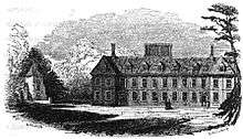
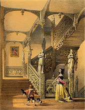
Aldermaston was held by the Achard family until the 14th century, when it passed through marriage to Thomas De La Mare of Nunney Castle, Somerset.[6][10] The De La Mare family governed Aldermaston for approximately 120 years, until Elizabeth de la Mare—whose male relatives predeceased her—married into the Forster family.[6] In about 1636, the Forsters built a large manor house to the east of the church. The house incorporated parts of an earlier (15th century) house, including the chimney stacks.[4] The Forsters' house was fronted by two porches, separated by a central section with seven bays.[12] The porches had ornate Solomonic columns, similar to those at the University Church of St Mary the Virgin in Oxford.[12] The interior of the house featured a number of mythical statues,[13] as well as artwork by Gaspard Dughet, portraits of William Congreve and Godfrey Kneller, and Tintoretto's Esther Before Ahasuerus.[14] The house's Jacobean garden featured patterns of groves and avenues of oak, yew, Spanish chestnut and lime trees.[11] In the early 18th century the Forsters oversaw the building of almshouses in Church Road. Built by R Dixon in 1706, the houses became known as "Dixon's Cottages". The manor passed through the Forster family until 1752, when the Forster lineage ended and the estate was inherited by Ralph Congreve, the husband of the last Forster's grand-niece.[6]
Victorian era
On Ralph's death a second-cousin of dramatist William Congreve inherited the manor.[15] The Congreve Family owned the estate at the time of the 1830 Swing Riots. The rioters marched across Aldermaston, wrecking twenty-three agricultural machines. Workers were so frightened by the riots that they left their machinery in the open in an attempt to limit additional damage.[16]
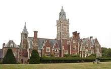
In 1843, the manor house was destroyed by fire, news of which was carried in The Illustrated London News.[11] The estate passed into the Court of Chancery and was purchased by Daniel Higford Davall Burr. In 1848, Burr commissioned the building of a neoclassical mansion to the south west of the original building. Burr saved the 17th-century manor's wooden staircase, though all that remains of the building is a staircase to the cellar (which is now home to a colony of bats).[11] By 1851 the new building was complete, costing £20,000 and having a Tudor-like appearance.[17] Burr held the estate until his death 50 years later, when was inherited by his son, who sold it in 1893.
The buyer was wealthy stockbroker Charles Edward Keyser, who was preoccupied with the idea of keeping the village unchanged—or, as he described it, "unspoilt".[18] He forbade advertisements, opposed all modernisation and refused to allow any expansion by the building of houses. He did, however, commission the building of a parish hall in 1897 and provided the village with a water supply,[19] and the water fountain on the small village green was installed to commemorate Queen Victoria's Diamond Jubilee. Keyser oversaw the restoration of the village almshouses in 1906 and 1924, and defrayed the cost of a memorial oak tablet in memory of those killed in World War I. Of the 100 men from the village who served in the war, 22 were killed (the highest percentage of town population in the country). The tablet bears the name of each man lost in action.[20]
During Keyser's lordship, John Marius Wilson's Imperial Gazetteer of England and Wales listed Adminston as a possible name for the village.[15] On his death in 1929, his wife, Mary, continued to occupy the house until she died in 1938. The estate was auctioned off in September 1938, and many lots were purchased by their occupiers. The manor house was bought by Associated Electrical Industries (AEI) for £16,000.[21] One of the houses in the village is recorded as having fetched £1,375.[22] As AEI's chairman, Felix Pole became the de jure Lord of the Manor upon their purchase of Aldermaston Court.[23]
Post-World War II
During the 1940s RAF Aldermaston was created on the parkland at the southern end of the parish, with XIX Tactical Air Command stationed at the manor house.[24] After World War II, the manor was returned to AEI who built the MERLIN reactor on part of the land. The reactor was opened on 6 November 1959 by The Duke of Edinburgh.[25] With the opening of the Atomic Weapons Research Establishment (AWRE) in 1950, Aldermaston became synonymous with a number of CND marches.[26]
In 1953, Pole stepped down as Lord of the Manor and was succeeded by AEI's senior representative, Thomas Allibone. Allibone held the position for 32 years, until Blue Circle Industries acquired the estate in 1985.[27] Allibone was succeeded by Tony Jackson, and the current Lord of the Manor is Andy Hall.[28] Blue Circle could not gain planning permission in the grounds of the court, so the MERLIN reactor was demolished to make way for Portland House. With a full redevelopment of Aldermaston Manor, the £14 million office development became Blue Circle's international headquarters and the complex was opened by Prince Richard, Duke of Gloucester.[22]
Toponymy
The village of Aldermaston derives its name from Ældremanestone, Eldremanestune or Hedlremanestone, the Old English for "Ealdorman's Homestead".[19] The Ealdorman—or Alderman—was a person of extreme importance, equating to the modern-day Lord-Lieutenant of the County. Although his country estate was in Aldermaston, he would have spent most of the time in the original county town of Wallingford.[16] The Anglo-Saxon Chronicle states that the first known Ealdorman of Berkshire, Aethelwulf, fought the Danes with Ethelred of Wessex at the nearby Battle of Englefield in 871.[29]
Other documented names include Aldermaston ad Pontem (11th century),[4] Aldremanneston (12th century),[30] Aldremaneston (13th century),[30] Aldermanston and Aldermanneston Achard (14th century),[4][31] and Aldmerston (19th century).[32]
Governance
Historically, Aldermaston was a hundred, though for a period it was within the Theale hundred.[33] By the 19th century, the hundreds had been superseded by other sub-divisions. From then on, Aldermaston was, at times, part of the Bradfield Poor Law Union and Sanitary District, and the registration sub-districts of Mortimer (late 19th century) and Bucklebury (early 20th century).[33] It was at all times an ecclesiastical parish and acquired civil parish status in the 1890s.[33]
The civil parish council is elected by every resident on West Berkshire elections.[34] It is in the area of West Berkshire unitary authority. The electoral ward of Aldermaston includes the neighbouring parishes of Wasing, Brimpton, Midgham, and Woolhampton.[35] The ward is the smallest in West Berkshire by population.[36] The ward's councillor is Dominic Boeck, who represents the Conservative Party.[37]
Aldermaston is under the catchment of Thames Valley Police and is covered by the Brimpton Neighbourhood Policing Team.[38] In a meeting with Aldermaston Parish Council, the police reported that 57 criminal offences were reported to have taken place in the parish between 2009 and 2010.[39] Of this, the majority was theft from non-dwelling properties. Vehicle crime had dropped by 57% on the previous year but violent crime had risen from four to six incidents. Five of these crimes were reported to be domestic violence. There have been no reported cases of robbery in Aldermaston since 2006.[39]
Geography
Aldermaston is in West Berkshire, about 2 miles (3.2 km) from the Hampshire boundary. The village is 1 mile (1.6 km) south of the A4 road that links the parish with Newbury and Reading. The main road in Aldermaston, The Street, is part of the A340 road and links the village with Pangbourne and Basingstoke. The course of Ermin Street, the Roman road that linked Calleva Atrebatum (Silchester) with Glevum (Gloucester) via Corinium Dobunnorum (Cirencester) runs south of the village, but none of the road survives in the area.[40]
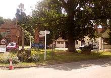
At the southern end of The Street is a small triangular village green called The Loosey—supposedly named after a "Lucy" who planted the oak tree which stands on the green.[41] The Loosey is the site of a Roman well, discovered in 1940 by a cow that almost fell down it.[18] The Loosey was previously home to the village maypole (which was often climbed by Daniel Burr's monkey) and a drinking fountain erected by Charles Keyser to celebrate the Diamond Jubilee of Queen Victoria.[18]
The River Kennet and River Enborne flow through the parish. The confluence of the rivers is approximately 0.6 miles (0.97 km) north of the village.[42] The Kennet and Avon Canal forms part of the parish's boundaries with Woolhampton and Padworth.
Sections of Grim's Bank are in the parish. Part of the earthwork in the AWE complex survives at a height of 3.3 metres (11 ft) and with a ditch 0.9 metres (3.0 ft) deep.[43]
The village has a couple of sites of special Scientific Interest called West's Meadow and Aldermaston Gravel Pits.[44][45]
Geology
The landscape of Aldermaston is influenced by Paices Hill and Rag Hill, which are extremities of the chalk formation the North Wessex Downs as part of the Thames Basin Heaths.[46][47] The topography of the land in the parish generally slopes northward to the River Kennet.[42]
The soil in the parish is high in clay. Due to the parish's location within the Kennet Valley there is a high concentration of alluvium, with the content largely determined by the London Clay Formation, the Bagshot Formation, and the Bracklesham Beds.[4]
Flooding
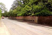
The quite flat low clay of Aldermaston's north has with exceptional rainfall led to flooding certain populous streets on three occasions — 1971, 1989, and 2007.[48][49] The flood in 1971 caused by torrential rain was exacerbated by the non-porous tarmac and buildings of the Atomic Weapons Establishment which managed for the first time to overwhelm its balancing ponds.[49] This happened again in July 1989, when an average of 6 inches (150 mm) of rain was deposited across the parish in two hours; water rose 5 feet (1.5 m) above the ponds and broke through a brick wall. The destroyed wall was rebuilt with 17 grilles to avoid another build-up of water.[50] A donation of £10,000 was given to the village by Blue Circle.[51]
In July 2007, torrential rain flooded some of the traditional village centre and primary school.[52] The storm coincided with the annual Glade music festival and jeopardised the event.[53] The festival gates were temporarily closed while organisers assessed the flooding, which submerged one of the stages.[54] The festival's car park was incapacitated, with thousands of revellers stranded in the village and surrounding lanes.[55]
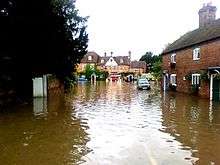
The floods also hit the Church of England primary school, with the Royal Berkshire Fire and Rescue Service evacuating pupils and staff from the school in life rafts.[26][56] The evacuation used four rafts, rescuing pupils and teachers from the school through windows.[57] The 165 people (140 pupils and 25 members of staff) were taken uphill to the parish hall, where blankets and sleeping bags had been provided.[52]
Ian Henderson, a police constable at Thames Valley Police stated that the emergency services were "really stretched because of what happened over the county and the Glade event", that "the [A340] junction was two or three-foot under water", and predicted that "a lot of householders [would be] homeless."[52]
Demography
The 1831 census showed that 68% of the employed population of Aldermaston were working class or "labourers and servants".[58] 20% were middle class ("middling sorts"), 10% were upper class ("employers and professionals") and 2% were unclassified.[58]
In 1887 the population of the parish was 528.[59] By 1896, the population had grown to 585.[15] The population fluctuated steadily around 550 until the 1950s and 1960s, when a population explosion resulted in the 1961 UK census reporting 2,186 residents in the parish.[60] This coincides with the opening of the Atomic Weapons Establishment in the early 1950s, and the majority of this figure counts residents in the parts of Tadley within the parish of Aldermaston[61]—between 1901 and 1961, 368 houses were built in the parish.[62]

Aldermaston Village
Aldermaston Wharf
Falcon Fields
Ravenswing/Pinelands
Raghill and other outlying areas
A number of parish border changes occurred in the first half of the 20th century, including the net loss of 307 acres (124 ha) to Beenham and Woolhampton on 1 April 1934 alone.[64] By 2001, the parish population had reduced to 927.[35]
The 2001 United Kingdom Census identified that 99.3% of householders in the parish as white.[65] In 2005 30% of parish residents lived in the village.[66] Of the 70% outside the village, 30% lived at Aldermaston Wharf, 20% in the local mobile home parks, 10% in the Falcon Fields development and 10% in "other outlying areas".[63] Falcon Fields is a housing development on the southern border of the parish, completed in the early 2000s. Ravenswing and Pinelands are mobile home parks near the Hampshire border.[67][68] Raghill is an industrial area to the east of the parish, which has some light residential developments.
The average age of residents in the parish is approximately 50 with 31.5% of residents in the 45–64 age group.[65] The average age of residents of Aldermaston Wharf is 30.7, and in the mobile home parks the average age is 53.9.[63] Of these, 53.3% were female.[63] This is in contrast with the 2001 census data, which showed that 49.8% were female.[65]
In 2005, 3% of the parish population were unemployed and 25% were retired.[63] The retirement figure increased in the Pinelands and Ravenswing areas, with a statistic of 42%.[63] Most residents' places of work are in surrounding towns, with their location in the parish largely dictating where to look for work. The 2005 survey identified that residents in the south of the parish (Falcon Fields and Ravenswing/Pinelands) travel towards Tadley and Basingstoke whereas those further north in the parish tend to find work in Reading, Newbury and London.[69]
| Historical population of Aldermaston | |||||||||||
| Year | 1801 | 1811 | 1821 | 1831 | 1841 | 1851 | 1861 | 1871 | 1881 | 1891 | 1901 |
|---|---|---|---|---|---|---|---|---|---|---|---|
| Population | 672 | 678 | 653 | 636 | 662 | 783 | 585 | ? | 528 | 655 | 482 |
| Year | 1911 | 1921 | 1931 | 1941 | 1951 | 1961 | 1971 | 1981 | 1991 | 2001 | 2011 |
| Population | 559 | 533 | 461 | ? | 638 | 2,186 | ? | ? | ? | 927 | 1,015 |
|
Census (1801 – 2001);[60] Census 2011;[1] Cassey's History, Gazetteer and Directory of Berkshire and Oxfordshire (1868)[70] | |||||||||||
| Output area | Homes owned outright | Owned with a loan | Socially rented | Privately rented | Other | km² roads | km² water | km² domestic gardens | Usual residents | km² |
|---|---|---|---|---|---|---|---|---|---|---|
| Civil parish | 234 | 135 | 28 | 46 | 9 | 0.2 | 0.4 | 0.3 | 1,015 | 13.4 |
Economy
Historically, the main source of industry in Aldermaston has been agriculture. According to the 1831 census, approximately 66% of working men (aged 20 and over) were employed in some form of agriculture.[71] The next highest industry by workers was "retail and handicrafts", which employed approximately 20%.[71] Employment categories in the 1881 census were more discreet; just 20% of working men identified their employment as agriculture. 30% however, were listed as "general or unspecified commodities".[71] In this census, women's employment was also documented. Of the 137 working women in the parish, 40 (slightly fewer than 30%) worked in domestic services, whereas 82 (approximately 60%) were of an unknown occupation.[71]
Agriculture
In about 1797[72] a schoolmaster living in the village cultivated the Williams pear. The schoolmaster (either Mr Wheeler[72] or his successor, John Stair[73]) was the original cultivator, but the pear (a cultivar of the European Pear) was named after Richard Williams of Turnham Green, who grew several grafts of the original tree.[72] On 5 December 1956, a plaque commemorating the tree was unveiled on the wall of the village school.[72]
Locally farmed wheat was milled at Aldermaston Mill until the 1920s.[74] In existence at the time of the Domesday survey, the mill was previously called the "Kingsmill", and at one time supplied flour to Huntley & Palmers in Reading.[75] Now known as The Old Mill, it was owned by Wasing's Mount family throughout the 18th and 19th centuries. William Mount let the mill to Francis Webb (1797–1811), Mr Sherwood (1811–1820), Mr King (1820–1824), Mr Waldren (1824–1828), Mr Mathews (1828–1848), and William Gilchrist (1848–1856).[76] Gilchrist (Mathews' business partner) bought the mill from Mount in 1856 using money inherited from his brother's death the previous year.[77] Owning it outright for approximately a year, he drowned in the River Kennet in 1857 after visiting the Angel public house in Woolhampton.[77] Joseph Crockett purchased the mill in an auction the same year, before it was acquired by a Richard Sisling of Godalming in 1858. In approximately 1860, the mill was purchased by the Kersley family. Between then and 1885, it was operated by Anthony Kersley, a miller and maltster who employed "six men and a boy, a carter, several domestic servants and a governess".[77] Kersley's son, also named Anthony, ran the mill until 1895. That year, Walter Parson bought the mill and operated it until approximately 1897. Charles Keyser subsequently oversaw restoration on the mill building which "had been untenanted for upwards of three years". He let the mill out to a Mr Iremonger from 1901. Iremonger used the mill until the late 1920s, shortly before Keyser's death.[77] After Keyser had died and the Aldermaston estate had been divided and sold, his widow, Mary, approached Evelyn Arlott to run the mill as a tea room and guesthouse. The Arlott family purchased the mill in approximately 1939, after the death of Mary Keyser.[78]
In 1939, there were seven farms on the Aldermaston estate —Forsters Farm, Village Farm, Church Farm, Upper Church Farm, Raghill Farm, Park Farm, and Soke Farm. These accounted for approximately 75% of the estate's land.[79] Aside from these, there were six smallholdings within the parish but outside the land owned by the court. These were Springhill Farm, Court Farm, Strawberry Farm, Circus Farm, Ravenswing Farm, and Frouds Farm.[79]
Of these, Church Farm and Forster's Farm remain in operation.[80] Upper Church Farm was originally known as Harry's Farm, after a William Harry who died in 1544.[81]
Pubs and brewing
The local pub is named The Hind's Head in honour of the Forster family crest. Built in the 17th century and originally operating as a coaching inn,[82] the establishment was named The Pack Horse during the De La Mare and Forster lordships and The Congreve Arms throughout the Congreves' ownership.[83][84]
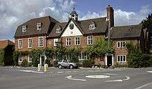
The building has a large black and gold clock set into the gable, and a small bellturret upon which is a gilt fox-shaped weather vane.[82] The bell was intended to be rung as an air-raid siren during the Second World War.[85] In the early 19th century the pub's signboard carried the arms of the Congreve family, as well as branding for a company named "Adams". In the British Parliamentary Papers of 1817, the Committee on the State of the Police in the Metropolis reported evidence of a John Adams—a Reading-based distiller and hop merchant—who competed for business against Simonds' Brewery.[86] By 1850, the pub brewed beer on-site; a brewery was built as an out-building behind the main pub building. John Knight produced beer at the pub for 40 years, selling it for 2d. The brewery building is still in existence, with the wooden louvres still operational.[85] The building is now the pub's kitchen. In the 1970s, the pub was owned by Whitbread.[85][87] In the mid-1990s the pub was taken over by Gales Brewery (having previously been a free house), later becoming tied to Fuller's Brewery on their acquisition of Gales in 2006.[88][89] In the 1970s, the pub was home to the Kennet Folk Club.[85]
The pub has its own gaol-house, the lock-up, at the rear. Built out of red brick, the small single-storey building has a shallow domed roof. The inside of the lock-up measures approximately 7.5 feet (2.3 m) by 6 feet (1.8 m), and is enclosed by a studded door with a grille.[90] It was last used in 1865 and its drunk inhabitant burnt himself to death trying to keep warm.[22][83] The lock-up was designated as a Grade II listed building in April 1967.[91] On 11 September 2010 the lock-up was opened to the public as part of the Heritage Open Days scheme.[90]
Another pub in the parish, The Butt Inn, is located approximately 1.25 miles (2.01 km) north-east of the village.[92] The pub is named after the archery butts that were located in the fields opposite the pub.[93] The Falcon Inn was on the southern border of the parish. The pub, which closed in 2009, was demolished in 2011 to improve traffic flow to AWE.[94] In 2013, the adjacent petrol station was rebuilt, extending onto the pub site.
The Aldermaston Brewery was established at Aldermaston Wharf in 1770, and was demolished in the 1950s.[95] It was replaced with a cable factory, which was demolished in 1990.[96]
Cricket bats
Old Village Farm (on Fishermans Lane) is now the location of a wood yard, used since the 1930s to prepare local willow for the production of cricket bats.[97] The trees are grown at Harbour Hill Copse,[98] where 70 trees are felled annually for this purpose. There are approximately 1000 trees growing at any given time.[99] The workers at the yard cut the wood into approximate bat shapes, then cure the wood in a kiln. The clefts of wood are then shipped to India where the final manufacturing can be undertaken under moisture-controlled conditions.[98]
The yard would take on three up-coming cricketers for the winter, in the hope that the hard work would "toughen them up" to get them picked for the England cricket team. One year the yard had help from Frank Tyson, Alan Moss, and Peter Loader. The following year they hosted three Davids—David Kaufman, David Spragbury, and David Gibson.[100]
The wood yard was featured on A Question of Sport, when cricketer Graham Gooch took part in the programme's "Mystery Guest" round.[101] Gooch endorsed the bats made from Aldermaston willow, which were sold by Surridge. When he scored 333 runs against India at Lord's in the 1990 test season, the Turbo 333 bat, made from Aldermaston wood, was launched in his honour.[102]
In the 1960s, Blue Peter aired a short documentary on the cricket bat production entitled "The Life of a Cricket Bat". It was presented by Christopher Trace.[100]
Pottery
In 1955, the Aldermaston Pottery was established on the main street[103] by studio potters Alan Caiger-Smith and Geoffrey Eastop.[103] The pottery was renowned for tin-glazed and porcelain wares,[103] which used scrap wood from the Village Farm woodyard to fire the kiln.[104] The pottery closed in 2006.[105] It had previously scaled back its output in 1993 due to Caiger-Smith's partial retirement after the 1992 recession.[106]
Atomic Weapons Establishment
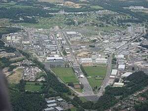
The Atomic Weapons Establishment (AWE), for which Aldermaston has become known,[107] is less than 1 mile (1.6 km) south of the village. The establishment is where the UK designs and manufactures the warheads for its stock of Trident missiles, and where decommissioned and redundant nuclear warheads are dismantled.[107] In April 1958, the first Aldermaston March was held.[108] The march saw around 3,000 protesters march from London to Aldermaston over four days, with a total attendance of 12,000 at the establishment's gates.[108] The 50th anniversary of the event was marked on 24 March 2008 with the "Bomb Stops Here" protest, attended by Vivienne Westwood and CND president Walter Wolfgang.[109][110] The 2008 demonstration was the biggest protest staged by CND in ten years.[111] Until 2005, AWE discharged "pre-treated waste water"[112] into the River Thames at Pangbourne via an 11.8 miles (19.0 km) pipeline which runs under roads and fields within the parish.[113] A water processing facility was installed on-site in 2006, though the Pangbourne Pipeline remains in situ.[112]
Other businesses
Lafarge Aggregates owns various sites in the parish. In 1974 the village won an appeal against Pioneer Concrete's application for gravel extraction near the village.[114] Similar events took place in March 2003 when hundreds of local residents protested against an application of gravel extraction by Lafarge.[115] Larfarge's initial appeal, in April 2003, was turned down by West Berkshire Council. A further application to extract aggregate at the Wasing Estate was due to be decided in 2010.[48] One former extraction site, Butts Lake Quarry, is now a nature reserve and the flooded lakes have been identified as a Site of Special Scientific Interest and is now operated by the Berkshire, Buckinghamshire and Oxfordshire Wildlife Trust.[116] The reserve contains specimens of trees such as alder, cherry, hawthorn, oak, and willow. Examples of reeds present include typha latifolia, phragmites australis, mentha aquatica, and lythrum salicaria. Numerous species of bird nest in the reserve, including the common teal, shoveler, warbler, kingfisher, water rail, and nightingale.[116]
Britain's first roadside petrol filling station was opened by The AA on the Bath Road near Aldermaston on 2 March 1919.[117][118][119] The following year, one villager requested that a pump be installed by his house. "Chuffer" Ford, who lived in The Forge with his wife Olive,[120] was told by Keyser that it must be "behind a wall and recessed".[121] A hole was cut in the brick wall beside Ford's yard to house the Shell-branded pump.[120] The location of this pump is marked by a square hole in the present wall. Ford's business offered other motoring services, with signage reading "vacuum, oil, and cycles".[122]
There is a number of small businesses in the village, including a hairdressing salon, a software development company and the village shop.[123] In the 1970s the hairdressers was a music shop, which was opened by Terry Wogan.[124] Before this it was a cooperative village stores started by Charles Keyser.[124]
There are two business parks in the parish—Calleva Business Park (on the Berkshire/Hampshire border)[125] and Youngs Industrial Estate (on Paices Hill).[126] The latter opened in the early 1980s, and is the location of Paices Wood Country Parkland, a wildlife project managed by the Berkshire, Buckinghamshire and Oxfordshire Wildlife Trust.[127]
In 2007 Aldermaston won the Business Category Award in the regional final of the Calor Village of the Year competition.[128] The judges stated that the village "has a very successful business community" and that "local businesses are well-supported by villagers and in return these businesses support village activities".[129] In addition to the business award, the village was announced as the Overall Winner of the Calor "Berkshire Village of the Year" competition in 2006, as well as category winners in the "Building Community Life", "Business", "Young People" and "ICT" categories.[130][131]
Architecture
The majority of houses in the village were built between the 17th and late 19th centuries, including examples of Victorian Gothic architecture.[82] Only one house has been built on the village's main street since the early 20th century.[132] The parish hall, built in 1897, is predominantly flint and brick.[133]
Most of the houses in the village are Grade II listed buildings, and many were built using local red and blue bricks.[83] In total, 51 structures in the parish are listed,[134] including gatepiers,[135] greenhouses,[136] a tomb,[137] railings and a wall,[138][139] the village telephone box[140] and Aldermaston Lock.[141]
Culture
Since the early 1800s, Aldermaston has held a candle auction every three years. The open auction starts with a horseshoe nail driven through a tallow candle an inch below the wick and lit in the parish hall.[142] The lot is the lease of Church Acre,[16] a plot of 2 acres (0.81 ha) granted to the church in 1815 after the Inclosures Act.[82][143] The proceedings are overseen by the vicar and churchwardens, who drink rum punch throughout the auction. Traditionally, the churchwardens smoked clay pipes during the event.[82][142]
The parish hall often holds other events, such as plays produced by the village's own amateur dramatics society. The society, known as The Aldermaston Players, have staged fundraising events in the village 1996.[144] In 1976, the parish hall hosted an episode of the BBC's Any Questions?.[145]
The village, along with the neighbouring parish of Wasing, holds an annual produce show at The Old Mill.[146] The show, which was previously held behind the Hind's Head pub,[147] hosts produce competitions in approximately 100 classes.[146] In the 1990s, a team of gardeners formed from the produce show entered the Chelsea Flower Show. They won a silver gilt in the Best Courtyard Garden Award in two consecutive years, for gardens named "Calma" and "Time Lords".[148]
Since 1957 there has been an annual performance of the York Nativity Play from the 15th century York Mystery Cycle. The play follows a script by E. Martin Browne with carols by William Byrd, Johannes Eccard, and Michael Praetorius.[149] The performances are at the Church of St Mary the Virgin in early December, and the actors are local people who have appeared in the play for many years.[150] In 1964, the play was recorded and broadcast by the BBC Home Service under the title of Star Over Aldermaston. One member of the production team was David Shute.[151]
Aldermaston was mentioned in Plum Pie (1966) by P. G. Wodehouse—"Every now and then we march from Aldermaston, protesting like a ton of bricks... And then we sit a good deal."[119] This was a reference to the demonstrations of the Campaign for Nuclear Disarmament (the Aldermaston Marches) which took the form of marches from Aldermaston to London (apart from in 1958, when the march went from London to Aldermaston). This was an annual march from 1958 to 1963.[152] Aldermaston was the original location of The Glade Festival. The 2007 event was jeopardised by torrential rains and flooding but cautiously went ahead.[54] In 2009, the festival moved from the area[153] and was held near Winchester.[54] Since 2006, the village has held a blues festival known as "Blues on the Meadow".[154]
The parish of Aldermaston forms a group with the local parishes of Wasing and Brimpton. The three share a monthly Parish Magazine featuring stories from churches, organisations, schools, businesses and various miscellany.[155]
Transport
Aldermaston railway station is in Aldermaston Wharf,[156] 1.5 miles (2.4 km) from the village itself. The station is managed by National Rail and served by Great Western Railway services between Reading and Newbury.
The village is on the A340 road, and has nearby access to the A4 road and the M4 motorway. A West Berkshire Council-run bus service, route 44, serves the village and provides a connection with Thatcham and Calcot[157] The 2005 Parish Plan identified a need for a relief road near the village. A report was presented in 2009 evaluating the problems caused by HGV traffic through the village,[158] and described solutions which included support from Newbury MP Richard Benyon.[159]
The nearest operating airstrip, Brimpton Airfield, is less than 1 mile (1.6 km) west of the village, within AWE's restricted airspace.[160] RAF Aldermaston ceased to operate as a civilian airport in 1950.[61]
The village is 1.5 miles (2.4 km) south-east of the Reading Marine Company's headquarters on the Kennet and Avon Canal,[161] which provides waterway links to London (via the Thames) and Bristol (via the River Avon).[162]
Education
The parish of Aldermaston has two primary schools. Aldermaston Primary School is a Local Authority-run Church of England school in Wasing Lane and has about 150 pupils.[163] It was established in 1836[133] and originally located in Church Road, moving to the present site in 1988.[164] The school uses the names of the manor's squires in its house system.[164]
The Cedars is a private school opened in 1992 in the former buildings of the Church of England school.[165] The school has approximately 40 pupils enrolled.[166]
Alder Bridge Steiner School, although located in Aldermaston Wharf, is within the parish of Padworth.[167] Padworth College is situated on the border of Aldermaston and Padworth parishes.
Religious sites
Parish church
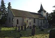
The Church of England parish church of Saint Mary the Virgin and was built in the mid-12th century. The Norman building was altered throughout the following millennium, particularly in 13th, 14th, 15th and 17th centuries.[168] The 12th-century building now comprises the current nave, with additions seen in the Forster Chapel and chancel (13th century), the steeple (14th century), and vestry (17th century).[168] The 17th-century Jacobean pulpit is an unusual heptagonal design.[20] Various additions were made to the structure in the 14th and 15th centuries, primarily to the walls and ogee windows.[168] A scratch dial was added to the south-west buttress in the 14th century.[20]
The church features architecture by Edward Doran Webb[168] and stained glass by Charles Eamer Kempe.[169] The Forster Chapel, a lady chapel added to the south face in the 13th century, contains the alabaster effigial monument of Sir George Forster and his wife Elizabeth which was built in 1530.[82] Evidence suggests that the chapel may originally have been a chantry dedicated to St Nicholas.[170] The roundel windows in the north wall date from the 13th century and are the oldest glass in Berkshire.[171]
The tower has a peal of eight bells dating from 1681 to 1900. The current organ, which has 16 stops, was installed in 1880.[172]
Individuals buried in the churchyard include squires Charles Keyser (1847–1929) and Daniel Burr (c.1811–1885), schoolmaster John Stair (c.1745–1820), and Maria Hale (1791–1879).[83]
Sport
Aldermaston has a number of sports teams. The village cricket team, Aldermaston Village CC, play at nearby Wasing Park.[173] The club, which first played in 1786 as "The Gentlemen of Aldermaston", originally played at a pitch at Aldermaston Court.[174] The ground was lost when the airfield was built. Sir William Mount, 2nd Baronet, the grandfather of British Prime Minister David Cameron, allowed a cricket pitch to be established on a portion of his Wasing estate.[175] The original football club played next to the cricket pitch. The club's strip was sponsored by Mr. George L Heighton, the proprietor of the village shop.[176]
Aldermaston Rugby Club and A.F.C. Aldermaston both play their home games at the Recreational Society at AWE.[177] Tadley RFC is in the parish,[178] about 1.5 miles (2.4 km) from the village.
Aldermaston Raceway, a banger racing,[179] demolition derby[180] and stock car venue, Fleet Motor Club, is the relocation of the Aldershot Raceway which closed in 2007.[179][181] A course for off-road 4x4 trials is close to the Raceway.[182]
Notable people
- Thomas Allibone, Lord of the Manor (1953–1985)[61]
- Alan Caiger-Smith, the studio potter, founded Aldermaston Pottery[183]
- Duncan Grant, painter, lived in the village with Paul Roche for the last few years of his life, and died in the village[184]
- Felix Pole, Lord of the Manor (1939–1953)[23]
- Paul Roche, poet, lived in the village[184]
Further reading
- Ford, D N (2001), "Aldermaston", Royal Berkshire History, Finchampstead, Berkshire: Nash Ford Publishing
- Keyser, C E (1911), Notes on the Churches of Aldermaston, Padworth, Englefield and Tidmarsh (PDF), Reading, Berkshire: Berkshire Archaeological Society
- Slater, I (1852), Royal National and Commercial Directory and Topography, London: Late Pigot & Co.
Footnotes
- Office for National Statistics (2011)
- Office for National Statistics (2010c)
- Cunliffe (2005, p. 37)
- Page & Ditchfield (1923, p. 2)
- Timmins (2000, p. 6)
- Timmins (2000, p. 7)
- Ford (2001)
- National Archives (1290)
- Camden (1610, p. 63)
- Topographer, The (1789, p. 33)
- Martin et al. (2005, p. 65)
- Mowl & Earnshaw (1995, p. 63)
- Piozzi, Bloom & Bloom (1996, p. 208)
- Knight (1840, p. 104)
- Wilson (1896)
- Ford (2005)
- Pevsner (1966, p. 45)
- Timmins (2000, p. 11)
- Aldermaston Parish Council (2007a, p. 1)
- Cox (1977, p. 4)
- Scott (2007, p. 1)
- Martin et al. (2005, p. 66)
- Timmins (2000, p. 12)
- Timmins (2000, p. 14)
- Martin et al. (2005, p. 25)
- BBC News (2007)
- Aldermaston Parish Council (2007a, p. 15)
- Martin et al. (2005, p. 63)
- Phillips (1980, p. 14)
- Gelling (1973, p. 198)
- National Archives (1339)
- Lewis (1835, p. 49)
- Youngs (1979, p. 14)
- Berkshire Family History Society (2004)
- Office for National Statistics (2010a)
- West Berkshire Council (2007a)
- West Berkshire Council (2010b)
- West Berkshire Council (2010a)
- Newbury Today (2010)
- Streetmap (2010)
- "Berkshire Archaeological Society". Berkshire Archaeological Journal. 94: 87. 1930. Retrieved 7 January 2016.
- West Berkshire Council (2007b, p. 3)
- Aldermaston Parish Council (2007b)
- "SITE NAME: WEST'S MEADOW, ALDERMASTON" (PDF). Archived from the original (PDF) on 4 March 2016. Retrieved 14 February 2017.
- "Magic Map Application". Magic.defra.gov.uk. Retrieved 19 March 2017.
- North Wessex Downs Area of Outstanding Natural Beauty (2010)
- Joint Nature Conservation Committee (2010)
- Newbury Today (2008a)
- Martin et al. (2005, p. 85)
- Martin et al. (2005, p. 88)
- Martin et al. (2005, p. 89)
- Newbury Today (2007a)
- Newbury Today (2007b)
- Virtual Festivals (2009)
- BBC Berkshire (2007b)
- Independent, The (2007)
- White (2007)
- Great Britain Historical GIS (2010d)
- Bartholomew (1887)
- Great Britain Historical GIS (2010a)
- Timmins (2000, p. 15)
- Great Britain Historical GIS (2010e)
- Aldermaston Parish Council (2006, p. 10)
- Great Britain Historical GIS (2010b)
- Office for National Statistics (2010b)
- Aldermaston Parish Council (2006, p. 22)
- Park Home Living (2010a)
- Park Home Living (2010b)
- Aldermaston Parish Council (2006, p. 11)
- Cassey (1868, p. 44)
- Great Britain Historical GIS (2010c)
- Martin et al. (2005, p. 3)
- USA Pears (2009)
- Cox (1977, p. 6)
- Martin et al. (2005, p. 53)
- Old Mill, The (2010, p. 1)
- Old Mill, The (2010, p. 2)
- Old Mill, The (2010, p. 5)
- Scott (2007, p. 6)
- Bucknell (1965)
- Cox (1977, p. 12)
- Reader's Digest Association (1990, p. 18)
- Aldermaston Parish Council (2007a, p. 3)
- Ingram, Ingram & Ridley (1976, p. 48)
- Ingram, Ingram & Ridley (1976, p. 49)
- Corley (1976, p. 79)
- Martin et al. (2005, p. 43)
- Klinger (2005)
- Portsmouth Today (2006)
- Heritage Open Days (2010)
- Images of England (2007a)
- Waterscape (2010a)
- Wordsworth Reference (2006, p. 68)
- Morton (2011)
- Berkshire Record Office (2010)
- Martin et al. (2005, p. 114)
- Aldermaston Parish Council (2006, p. 5)
- Aldermaston Parish Council (2010b)
- Padworth Parish Council (2010)
- Martin et al. (2005, p. 38)
- Martin et al. (2005, p. 50)
- Martin et al. (2005, p. 92)
- Studio Pottery (2006)
- Martin et al. (2005, p. 36)
- Ceramic Review (2006)
- Martin et al. (2005, p. 116)
- BBC News (2000)
- Campaign for Nuclear Disarmament (2008)
- BBC News (2008)
- Guardian, The (2008)
- Barnett (2008)
- AWE (2011)
- Nuclear Information Service (2003)
- Martin et al. (2005, p. 46)
- Martin et al. (2005, p. 188)
- English Nature (2006, p. 1)
- Jeremiah (1995, p. 100)
- Baker (2008)
- Ayto & Crofton (2005)
- Martin et al. (2005, p. 13)
- Bond (2008)
- Hill (1971, p. 156)
- Aldermaston Parish Council (2010c)
- Martin et al. (2005, p. 56)
- Calleva Park (2008)
- Youngs Industrial Estate (2008)
- Opening Times. "Paices Wood Country Parkland | Berks, Bucks & Oxon Wildlife Trust". Bbowt.org.uk. Retrieved 11 April 2017.
- BBC Berkshire (2007a)
- Calor (2007)
- Calor (2006)
- BBC Berkshire (2006)
- Aldermaston Parish Council (2007c)
- Scott (2007, p. 10)
- Images of England (2007b)
- Images of England (2007c)
- Images of England (2007d)
- Images of England (2007e)
- Images of England (2007f)
- Images of England (2007i)
- Images of England (2007g)
- Images of England (2007h)
- Aldermaston Parish Council (2007a, p. 4)
- Martin et al. (2005, p. 4)
- Aldermaston Players (2010)
- Martin et al. (2005, p. 48)
- Newbury Today (2009)
- Martin et al. (2005, p. 35)
- Martin et al. (2005, p. 153)
- Get Wokingham (2008)
- Newbury Theatre (2005)
- Martin et al. (2005, p. 31)
- Hudson, Kate (2005). CND – now more than ever : the story of a peace movement (1. publ. ed.). London: Vision Paperbacks. ISBN 1-904132-69-3.
- Newbury Today (2008b)
- Papworth (2010)
- Aldermaston Parish Council (2010a)
- National Rail (2010)
- West Berkshire Council (2018)
- Aldermaston Parish Council (2009, p. 2)
- Aldermaston Parish Council (2009, p. 9)
- Brimpton Airfield (2009)
- Reading Marine Company (2009)
- Waterscape (2010b)
- DirectGov (2010a)
- West Berkshire Council (2010d)
- Martin et al. (2005, p. 109)
- DirectGov (2010b)
- Newbury Weekly News (2008)
- Page & Ditchfield (1923, p. 5)
- Timmins (2000, p. 5)
- Timmins (2000, p. 4)
- Ford (2003)
- British Institute of Organ Studies (2008)
- Aldermaston Village Cricket Club (2010a)
- Aldermaston Village Cricket Club (2010b)
- Martin et al. (2005, p. 156)
- Martin et al. (2005, p. 55)
- Aldermaston RFC (2007)
- Tadley RFC (2010)
- Newbury Today (2011)
- Kusi Obodum (2011)
- Fleet Motor Club
- Burnham Offroaders (2009)
- Martin et al. (2005, p. 9)
- Martin et al. (2005, p. 49)
Sources
- AWE (2011), Aqueous Discharges (Environmental & Discharge Monitoring), Aldermaston, Berkshire: AWE plc, archived from the original on 17 May 2011, retrieved 16 April 2011
- Aldermaston Parish Council (2006), Aldermaston Parish Plan 2005 (PDF), Aldermaston, Berkshire, archived from the original (PDF) on 4 March 2011, retrieved 16 April 2011
- Aldermaston Parish Council (2007a), Aldermaston – A Brief History (PDF), Aldermaston, Berkshire, archived from the original (PDF) on 9 January 2016, retrieved 16 April 2011
- Aldermaston Parish Council (2007b), What is Grim's Bank? (Archaeological Investigation at Grim's Bank), Aldermaston, Berkshire
- Aldermaston Parish Council (2007c), Aldermaston Entry Submission for Regional Final (Berkshire Village of the Year 2007), Aldermaston, Berkshire, retrieved 16 April 2011
- Aldermaston Parish Council (2009), Aldermaston Relief Road Working Group (PDF), Aldermaston, Berkshire, archived from the original (PDF) on 9 January 2016, retrieved 16 April 2011
- Aldermaston Parish Council (2010a), Parish Magazine, Aldermaston, Berkshire, retrieved 16 April 2011
- Aldermaston Parish Council (2010b), Aldermaston – Cricket's Secret Weapon (Display at the Hind's Head), Aldermaston, Berkshire
- Aldermaston Parish Council (2010c), Local Businesses, Aldermaston, Berkshire, retrieved 16 April 2011
- Aldermaston Players (2010), History of Troupes, Aldermaston, Berkshire, archived from the original on 23 March 2011, retrieved 16 April 2011
- Aldermaston RFC (2007), History, Aldermaston, Berkshire, archived from the original on 12 December 2008, retrieved 16 April 2011
- Aldermaston Village Cricket Club (2010a), About Aldermaston Village Cricket Club, Aldermaston, Berkshire, retrieved 16 April 2011
- Aldermaston Village Cricket Club (2010b), Club History, Aldermaston, Berkshire, retrieved 16 April 2011
- Ayto, J; Crofton, I (2005), Brewer's Britain and Ireland, London: Chambers Harrap, ISBN 978-0-304-35385-9
- BBC Berkshire (2006), Aldermaston is Berkshire's village of the year!, Caversham, Berkshire: BBC Online, retrieved 16 April 2011
- BBC Berkshire (2007a), Berkshire Village of the Year, Caversham, Berkshire: BBC Online, retrieved 16 April 2011
- BBC Berkshire (2007b), Berkshire Floods 2007, Caversham, Berkshire: BBC Online, retrieved 16 April 2011
- BBC News (30 March 2000), Aldermaston: Britain's bomb factory, London: BBC Online, retrieved 16 April 2011
- BBC News (20 July 2007), Flooding misery across Berkshire, London: BBC Online, retrieved 16 April 2011
- BBC News (24 March 2008), March at Aldermaston 50 years on, London: BBC Online, retrieved 16 April 2011
- Baker, B (2008), History of Petrol Filling Stations (The Early Petrol Stations) (7 ed.), Moreton-in-Marsh, Gloucestershire: Institution of Fire Engineers
- Barnett, L (2008), March at Aldermaston 50 years on (Vogue magazine), London: Condé Nast Publications, archived from the original on 11 June 2011, retrieved 16 April 2011
- Bartholomew, J (1887), Descriptive Gazetteer Entry for Aldermaston (Gazetteer of the British Isles), London: Royal Geographical Society
- Berkshire Family History Society (2004), Berkshire Parishes, Reading, Berkshire, archived from the original on 12 August 2011, retrieved 16 April 2011
- Berkshire Record Office (2010), Records of Berkshire breweries subsequently owned by Whitbread & Co. plc, Reading, Berkshire, archived from the original on 19 January 2010, retrieved 16 April 2011
- Bond, R (2008), The Creation of 'Memories' (May 2008 News), Tadley, Hampshire: Tadley and District History Society, archived from the original on 14 May 2011, retrieved 16 April 2011
- Brimpton Airfield (2009), Airfield Data, Brimpton, Berkshire, retrieved 16 April 2011
- British Institute of Organ Studies (2008), Berkshire, Aldermaston; St. Mary the Virgin, Church Road (The National Pipe Organ Register), Birmingham, West Midlands, archived from the original on 23 December 2012, retrieved 16 April 2011
- Bucknell (1965), Records of Middle Farm, Ufton, Berkshire, Lower Farm, Denford, Berkshire and Forster's Farm, Aldermaston, Berkshire (The Bucknell Family Collection), Reading, Berkshire: Museum of English Rural Life, archived from the original on 27 July 2011, retrieved 16 April 2011
- Burnham Offroaders (2009), Burnham Off Roaders Drive Day: Christmas/New Year, Slough, Berkshire, retrieved 15 April 2011
- Calleva Park (2008), Welcome, Tadley, Hampshire: Calleva Park
- Calor (2006), Calor Berkshire Village of the Year Winners Honoured, Warwick, Warwickshire: Calor Gas Ltd (Berkshire Village of the Year), retrieved 16 April 2011
- Calor (2007), Judges' Comments (Berkshire Village of the Year) (PDF), Warwick, Warwickshire: Calor Gas Ltd, archived from the original (PDF) on 9 January 2016, retrieved 16 April 2011
- Camden, W (1610), Britain, or, a Chorographicall Description of the most flourishing Kingdomes, England, Scotland, and Ireland, London: George Bishop and John Norton, retrieved 16 April 2011
- Campaign for Nuclear Disarmament (2008), A brief history of CND (CND Information), London, retrieved 16 April 2011
- Cassey, Edward (1868), History, Gazetteer and Directory of Berkshire and Oxfordshire, London: Edward Cassey and Co, retrieved 18 April 2011
- Ceramic Review (2006), CR 221, Sep/Oct 2006 (Ceramic Review Magazine), London: Ceramic Review Publishing, archived from the original on 8 July 2011, retrieved 16 April 2011
- Cox, B (1977), Souvenir Brochure of the Silver Jubilee of Her Majesty Queen Elizabeth the Second (PDF), Aldermaston, Berkshire: Silver Jubilee Committee, retrieved 16 April 2011
- Corley, T (1976), Symonds' Brewery at Reading (1760–1960), 68, Reading, Berkshire: Berkshire Archaeological Journal
- Cunliffe, B W (2005), Iron Age Communities in Britain: An Account of England, Scotland and Wales from the Seventh Century BC Until the Roman conquest, Abingdon, Oxfordshire: Routledge, ISBN 0-415-34779-3
- DirectGov (2010a), Aldermaston Church of England Primary School, London, archived from the original on 9 February 2012, retrieved 16 April 2011
- DirectGov (2010b), Cedars School, London, archived from the original on 9 February 2012, retrieved 16 April 2011
- English Nature (2006), Aldermaston Gravel Pits (PDF), Sheffield, South Yorkshire, archived from the original (PDF) on 27 September 2007, retrieved 16 April 2011
- Ford, D N (2001), Pedigree of the Lords of Aldermaston, Berkshire (The Royal County of Berkshire), Finchampstead, Berkshire: Nash Ford Publishing, archived from the original on 5 June 2011, retrieved 16 April 2011
- Ford, D N (2003), Aldermaston St Mary's Church (Royal Berkshire History), Finchampstead, Berkshire: Nash Ford Publishing, retrieved 16 April 2011
- Ford, D N (2005), Aldermaston (Royal Berkshire History), Finchampstead, Berkshire: Nash Ford Publishing, retrieved 16 April 2011
- Gelling, M (1973), The Place-Names of Berkshire, 49, University Park, Pennsylvania: Pennsylvania State University Press
- Get Wokingham (2008), Milestone for Historic Nativity Play (The Wokingham Times), Reading, Berkshire: Surrey and Berkshire Media, archived from the original on 18 July 2011, retrieved 16 April 2011
- Great Britain Historical GIS (2010a), Aldermaston CP/AP Population (A Vision of Britain Through Time), Portsmouth, Hampshire, retrieved 16 April 2011
- Great Britain Historical GIS (2010b), Aldermaston CP/AP Relationships / unit history of ALDERMASTON (A Vision of Britain Through Time), Portsmouth, Hampshire, archived from the original on 24 December 2012, retrieved 16 April 2011
- Great Britain Historical GIS (2010c), Aldermaston CP/AP Historical Statistics – Industry (A Vision of Britain Through Time), Portsmouth, Hampshire, retrieved 16 April 2011
- Great Britain Historical GIS (2010d), Aldermaston CP/AP Historical Statistics – Social Structure (A Vision of Britain Through Time), Portsmouth, Hampshire, retrieved 16 April 2011
- Great Britain Historical GIS (2010e), Aldermaston CP/AP Historical Statistics – Housing (A Vision of Britain Through Time), Portsmouth, Hampshire, retrieved 16 April 2011
- Guardian, The (2008), Anti-nuclear protest 50 years on, London: Guardian Media Group, retrieved 16 April 2011
- Heritage Open Days (2010), Village Lock-Up, London: English Heritage, archived from the original on 11 September 2010, retrieved 11 September 2010
- Hill, H (1971), Images of Reading and Surrounding Villages, Reading, Berkshire: Reading Evening Post, ISBN 1-85983-024-2
- Images of England (2007a), Details for IoE Number: 39494, London: National Monuments Record, retrieved 16 April 2011
- Images of England (2007b), Aldermaston, London: National Monuments Record, retrieved 16 April 2011
- Images of England (2007c), Details for IoE Number: 39507, London: National Monuments Record, retrieved 16 April 2011
- Images of England (2007d), Details for IoE Number: 39499, London: National Monuments Record, retrieved 16 April 2011
- Images of England (2007e), Details for IoE Number: 39503, London: National Monuments Record, retrieved 16 April 2011
- Images of England (2007f), Details for IoE Number: 39506, London: National Monuments Record, retrieved 16 April 2011
- Images of England (2007g), Details for IoE Number: 350306, London: National Monuments Record, retrieved 16 April 2011
- Images of England (2007h), Details for IoE Number: 39700, London: National Monuments Record, retrieved 16 April 2011
- Images of England (2007i), Details for IoE Number: 39505, London: National Monuments Record, retrieved 16 April 2011
- Ingram, C; Ingram, T; Ridley, P (1976), The History of Some Berkshire Inns and Their Signs, Reading, Berkshire: The Berkshire Federation of Women's Institute
- Independent, The (29 July 2007), Where were you during the Great Floods of July 2007?, London: Independent Print Limited, retrieved 16 April 2011
- Jeremiah, D (1995), Filling Up: The British Experience, 1896–1940 (Journal of Design History), 8, Oxford, Oxfordshire: Design History Society, retrieved 16 April 2011
- Joint Nature Conservation Committee (2010), Thames Basin Heaths (Special Protection Areas), Peterborough, Cambridgeshire, retrieved 16 April 2011
- Kennet and Avon Canal Trust (2010), History of the Canal (Kennet and Avon Canal Trust Museum), Devizes, Wiltshire, archived from the original on 2 April 2012, retrieved 16 April 2011
- Klinger, P (9 November 2005), Fuller's adds Gale's to its stable in £92 million deal, London: Times Online, retrieved 16 April 2011
- Knight, C (1840), Berkshire (The Journey-Book of England), London: Charles Knight & Co., retrieved 16 April 2011
- Kusi Obodum, M (2011), Banger racing rule change after rookie smash, Reading, Berkshire: Reading Post, retrieved 15 April 2011
- Lewis, S (1835), A Topographical Dictionary of England, 1, London: Samuel Lewis and Co, retrieved 16 April 2011
- Martin, S A; Braithwaite, R; Jeffcoate, P; Girling, T; Moore, C (2005), Memories of Life in an English Country Village, Aldermaston, Berkshire: The Book Project, ISBN 0-9549636-0-1
- Mowl, T; Earnshaw, B (1995), Architecture Without Kings: The Rise of Puritan Classicism Under Cromwell, Manchester, Greater Manchester: Manchester University Press, ISBN 0-7190-4679-3
- Morton, Helen (2011), Weapons chiefs level old pub to ease traffic flow, Basingstoke, Hampshire: Basingstoke Gazette, retrieved 24 August 2013
- National Archives (1290), Item reference C 241/14/38, Kew, Surrey: The National Archives, retrieved 16 April 2011
- National Archives (1339), Item reference C 241/111/262, Kew, Surrey: The National Archives, retrieved 16 April 2011
- National Rail (2010), Aldermaston (AMT) (National Rail Enquiries), Plymouth, Devon, retrieved 16 April 2011
- Newbury Theatre (2005), Aldermaston – The York Nativity Play, Newbury, Berkshire: Newbury Theatre, retrieved 16 April 2011
- Newbury Today (2007a), More problems as floods hit villages, Newbury, Berkshire: Newbury Weekly News, archived from the original on 19 July 2011, retrieved 16 April 2011
- Newbury Today (2007b), Festival-goers battle the tides, Newbury, Berkshire: Newbury Weekly News, archived from the original on 19 July 2011, retrieved 16 April 2011
- Newbury Today (2008a), MP Vows to Help Village "Under Siege" (PDF), Newbury, Berkshire: Newbury Weekly News, archived from the original (PDF) on 5 July 2010, retrieved 16 April 2011
- Newbury Today (2008b), Glade festival quits West Berkshire, Newbury, Berkshire: Newbury Weekly News, archived from the original on 19 July 2011, retrieved 16 April 2011
- Newbury Today (2009), Animal antics at Aldermaston fun day, Newbury, Berkshire: Newbury Weekly News, archived from the original on 29 September 2011, retrieved 16 April 2011
- Newbury Today (2010), Village Is One of Safest in West Berkshire (PDF), Newbury, Berkshire: Newbury Weekly News, archived from the original (PDF) on 5 July 2010, retrieved 16 April 2011
- Newbury Today (2011), Novice drivers to be banned from Aldermaston Raceway, Newbury, Berkshire: Newbury Weekly News, retrieved 15 April 2011
- Newbury Weekly News (9 October 2008), Learning Chemistry in the Woods, Newbury, Berkshire
- North Wessex Downs Area of Outstanding Natural Beauty (2010), The North Wessex Downs, Hungerford, Berkshire, archived from the original on 19 May 2011, retrieved 16 April 2011
- Nuclear Information Service (2003), Pangbourne Pipeline Closure (2005), Reading, Berkshire: Nuclear Information Service, archived from the original on 26 July 2011, retrieved 16 April 2011
- Office for National Statistics (2010a), Aldermaston (Ward): Key Statistics (Neighbourhood Statistics), London, retrieved 16 April 2011
- Office for National Statistics (2010b), Aldermaston CP (Parish): Parish Profile – Households (Neighbourhood Statistics), London, retrieved 16 April 2011
- Office for National Statistics (2011), Aldermaston CP (Parish): Key Figures for 2011 Census: Key Statistics, London, retrieved 6 April 2013
- Office for National Statistics (2010c), West Berkshire (Unitary Authority) (Neighbourhood Statistics), London, retrieved 16 April 2011
- Old Mill, The (2010), History (PDF), Aldermaston, Berkshire, retrieved 16 April 2011
- Padworth Parish Council (2010), Padworth Park Farm and Village Farm Aldermaston (Padworth Newsletter #18), Padworth, Berkshire, retrieved 16 April 2011
- Page, W; Ditchfield, P H (1923), A History of the County of Berkshire, 3, London: Victoria County History, retrieved 16 April 2011
- Paices Wood Country Parkland (2009), Padworth Park Farm and Village Farm Aldermaston (PDF), Newbury, Berkshire: West Berkshire Council, archived from the original (PDF) on 9 January 2016, retrieved 16 April 2011
- Papworth, J (2010), Shake away those blues, Reading, Berkshire: Reading Chronicle, archived from the original on 19 July 2011, retrieved 16 April 2011
- Park Home Living (2010a), Ravenswing Park (Residential Parks), Bracknell, Berkshire: Bruton Solutions, archived from the original on 21 April 2013, retrieved 16 April 2011
- Park Home Living (2010b), Pinelands Park (Residential Parks), Bracknell, Berkshire: Bruton Solutions, archived from the original on 22 March 2010, retrieved 16 April 2011
- USA Pears (2009), Yellow Bartlett (Recipes and Lifestyle), Milwaukie, Oregon: Pear Bureau Northwest, archived from the original on 17 July 2011, retrieved 16 April 2011
- Pevsner, N (1966), The Buildings of England: Berkshire, London: Penguin Books
- Phillips, D (1980), The Story of Reading, Newbury, Berkshire: Countryside Books, ISBN 0-905392-07-8
- Piozzi, H L; Bloom, E A; Bloom, Lillian D (1996), The Piozzi Letters: 1805–1810, Newark, Delaware: University of Delaware Press, ISBN 0-87413-393-9
- Portsmouth Today (2006), Bitter end to Gales brewery (The News), Portsmouth, Hampshire
- Reader's Digest Association (1990), Book of British Villages, London: Reader's Digest, ISBN 0-276-42018-7, OCLC 35330841
- Reading Marine Company (2009), Contact Us, Aldermaston, Berkshire, retrieved 16 April 2011
- Scott, B (2007), Aldermaston in 1939 (PDF), Aldermaston, Berkshire: Aldermaston Parish Council, archived from the original (PDF) on 9 January 2016
- Streetmap (2010), Aldermaston, West Berkshire, Newbury, Berkshire: Streetmap EU
- Studio Pottery (2006), Aldermaston Pottery, Maidstone, Kent: The Pottery Studio, retrieved 16 April 2011
- Tadley RFC (2010), Contact Us, Aldermaston, Berkshire, archived from the original on 23 September 2010, retrieved 16 April 2011
- Timmins, G (2000), Aldermaston: A Village History, Winchester, Hampshire: Hampshire County Council
- Topographer, The (1789), An Historical Account and Description of Aldermaston House in the County of Berkshire, 1, London: Robson, Walker, and Stalker, retrieved 16 April 2011
- Virtual Festivals (2009), Glade Festival blighted by flooding, London, archived from the original on 20 July 2011, retrieved 16 April 2011
- Waterscape (2010a), The Butt Inn, Watford, Hertfordshire: British Waterways, archived from the original on 7 September 2008, retrieved 16 April 2011
- Waterscape (2010b), Kennet and Avon Canal, Watford, Hertfordshire: British Waterways, retrieved 16 April 2011
- West Berkshire Council (2007a), Aldermaston Ward Profile (Policy and Communication), Newbury, Berkshire, retrieved 16 April 2011
- West Berkshire Council (2007b), Parish Flood Reports: Flooding in West Berkshire (Highways and Transport), Newbury, Berkshire, retrieved 16 April 2011
- West Berkshire Council (2010a), Aldermaston Home Page (Community and Living), Newbury, Berkshire
- West Berkshire Council (2010b), Councillors: Listed By Ward (Council and Democracy), Newbury, Berkshire, archived from the original on 18 July 2011, retrieved 16 April 2011
- West Berkshire Council (2010d), Ethos and Values – Vision Statement (Prospectus), Newbury, Berkshire, retrieved 16 April 2011
- West Berkshire Council (2018), District-wide Travel Guide (PDF), Newbury, Berkshire, retrieved 10 August 2020
- White, Helen (2007), Councillors: Listed By Ward (Council and Democracy), Newbury, Berkshire: Newbury Weekly News, archived from the original on 19 July 2011, retrieved 16 April 2011
- Wilson, J M (1896), "County of Berkshire", The National Gazetteer of Great Britain and Ireland, Portsmouth, Hampshire: A Vision of Britain, retrieved 16 April 2011
- Wordsworth Reference (2006), Dictionary of Pub Names, Ware, Hertfordshire: Wordsworth Editions, ISBN 1-84022-266-2
- Youngs, F (1979), Local Administrative Units: Southern England, London: Royal Historical Society
- Youngs Industrial Estate (2008), About Us, Aldermaston, Berkshire: Young Developments, archived from the original on 26 May 2007, retrieved 16 April 2011
External links
| Wikimedia Commons has media related to Aldermaston. |