Thames Basin Heaths
The Thames Basin Heaths are a natural region in southern England in the counties of Berkshire, Hampshire and Surrey.
The Thames Basin Heaths are recognised as national character area 129 by Natural England, the UK government's advisor on the natural environment. They cover an area of 118,529 hectares (457.64 sq mi) of countryside surrounding the towns of Newbury, Camberley and Woking To the west lie the Berkshire Downs, to the north the Chilterns and Thames Valley, to the east and southeast the Thames Basin Lowlands and to the south the Hampshire Downs.[1]
Environment
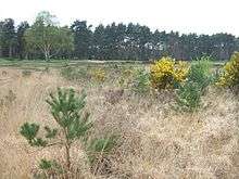
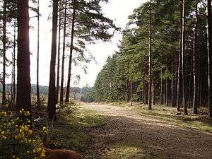
The terrain of the heathland is characterized by flat or gently sloping plateaux with numerous watercourses incising broad or sometimes steep-sided valleys. The land descends towards the east into the London Basin and along the main river valleys to the low-lying areas of the Kennet floodplain and lower reaches of the Loddon and Blackwater. At the western edge is the chalk scarp of the Hampshire Downs. The highest elevation is 296 metres.[1]
Drainage
The main watercourses are the Basingstoke Canal, the Kennet & Avon Canal, the Blackwater River and the rivers Kennet, Loddon, Wey, Whitewater, Pang and Mole.[1]
Protected areas
Just over 20,000 hectares (17%) lies within the North Wessex Downs AONB. The area contains two Special Protection Areas - Thames Basin Heaths SPA and South West London Waterbodies SPA - and three Special Areas of Conservation: Thursley, Ash, Pirbright and Chobham SAC; Kennet valley Alderwoods SAC; and Kennet & Lambourn Floodplain SAC. There are also three national nature reserves: Chobham Common NNR; Castle Bottom NNR; Ashford Hill NNR within the Thames Basin Heaths.[1]
There are many Sites of Special Scientific Interest or SSI's within the zone, such as one of the largest at the Broadmoor to Bagshot Woods and Heaths SSI where several rare birds and other species occur. The area also includes a Roman Road, the Devil's Highway (Roman Britain) and an Iron Age hillfort at Caesar's Camp, Bracknell Forest.
See also
References
- NCA 129: Thames Basin Heaths Key Facts & Data at www.naturalengland.org.uk. Accessed on 6 Apr 2013.