Ashmore Green
Ashmore Green is a small hamlet in Berkshire, England.[2][3] It is situated just to the west of the village of Cold Ash and to the north of Thatcham in the West Berkshire district.
| Ashmore Green | |
|---|---|
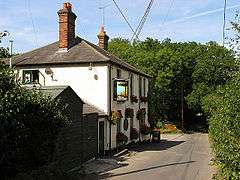 The Sun in the Wood (closed since 2018)[1] | |
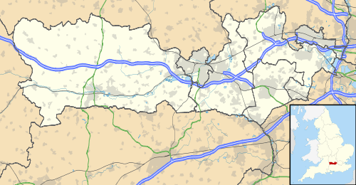 Ashmore Green Location within Berkshire | |
| OS grid reference | SU5069 |
| Shire county | |
| Region | |
| Country | England |
| Sovereign state | United Kingdom |
| Postcode district | RG18 |
| Police | Thames Valley |
| Fire | Royal Berkshire |
| Ambulance | South Central |
Etymology
The name Ashmore Green is probably of Saxon origin, meaning "Ash Tree covered Moor".[4] The Ash tree held significance for the Saxons due to the myth of Yggdrasil and the ash tree being sacred to the god Wōden.[5] Ash trees are common in Berkshire, as is reflected in other settlement names such as nearby Cold Ash, Ashampstead, as well as Ashford Hill and Ashmansworth in bordering Hampshire and Ashbury in Oxfordshire.
History
Ashmore Green is first mentioned in a deed in 1549 from John Winchcombe (Jack O'Newbury) to his son Henry.[6]
It is believed the Parliamentary Army stayed in fields near Ashmore Green during the Second Battle of Newbury in 1644.[7]
Ashmore Green was first noted on a map in 1761 spelled "Ashmoor Green". The area was largely moorland and heath until it began to be populated in the 1800s.[8]
In 1886 a baptist chapel was built in the centre of Ashmore Green, on Stoney Lane. It was closed in the 1960s.[8]
In 1894 Ashmore Green became part of the Cold Ash civil parish.[9]
The population of the Ashmore Green and Cold Ash area nearly doubled between 1900 and 1939, with major expansion after WW2.[6]
The local pub, The Sun in the Wood, built around 1900, closed in 2018.[1]
Nearby villages
References
- "Cold Ash councillors don't object to plans for The Sun in the Wood". https://www.newburytoday.co.uk/. Newbury Today. 28 April 2020. Retrieved 12 July 2020. External link in
|website=(help) - Ordnance Survey: Landranger map sheet 174 Newbury & Wantage (Hungerford & Didcot) (Map). Ordnance Survey. 2014. ISBN 9780319228739.
- "Ordnance Survey: 1:50,000 Scale Gazetteer" (csv (download)). ordnancesurvey.co.uk. Ordnance Survey. 1 January 2016. Retrieved 30 January 2016.
- "Ashmore Green". http://www.berkshirehistory.com/index.html. Nash Ford Publishing. 2003. Retrieved 13 July 2020. External link in
|website=(help) - "Yggdrasil". https://norse-mythology.org/cosmology/yggdrasil-and-the-well-of-urd/. Retrieved 13 July 2020. External link in
|website=(help) - "Cold Ash and Ashmore Green village design statement". https://www.westberks.gov.uk. West Berkshire council. 1 May 2002. Retrieved 13 July 2020. External link in
|website=(help) - "Cold Ash and Ashmore Green pathusers". Cold Ash Parish Council. Retrieved 13 July 2020.
- "Ashmore Green". visitoruk.com. VisitorUk. Retrieved 13 July 2020.
- "Thatcham Parishes". https://www.british-history.ac.uk/. British History Online. 1923. Retrieved 13 July 2020. External link in
|website=(help)
External links
![]()