Basildon, Berkshire
Basildon is a civil parish in the English county of Berkshire. It comprises the small villages of Upper Basildon and Lower Basildon, named for their respective heights above the River Thames. Basildon is 7 miles (11 km) from Reading, 47 miles (76 km) from London and 20 miles (32 km) from Oxford. The parish is bordered to the north by the River Thames and the Oxfordshire parishes of Goring and Whitchurch-on-Thames on the other side of the river. To the south of the river it is bordered by the parishes of Pangbourne, Bradfield, Ashampstead and Streatley.[2] The parish forms part of the unitary authority of West Berkshire. It is within the Newbury parliamentary constituency.[2]
| Basildon | |
|---|---|
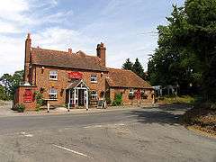
 The Intersection at the Red Lion | |
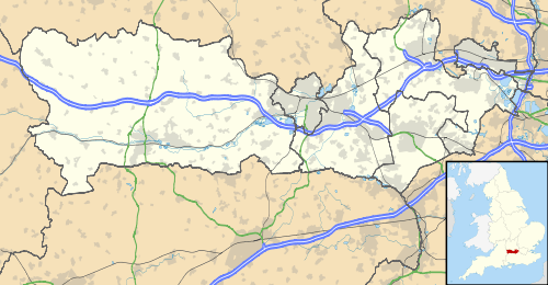
 Basildon Location within Berkshire | |
| Area | 13.67 km2 (5.28 sq mi) |
| Population | 1,747 (2011 census)[1] |
| • Density | 128/km2 (330/sq mi) |
| OS grid reference | SU599779 |
| Civil parish |
|
| Unitary authority | |
| Ceremonial county | |
| Region | |
| Country | England |
| Sovereign state | United Kingdom |
| Post town | READING |
| Postcode district | RG8 |
| Dialling code | 0118/01491 |
| Police | Thames Valley |
| Fire | Royal Berkshire |
| Ambulance | South Central |
| UK Parliament | |
Beale Park
Beale Wildlife Park and Gardens is located between Basildon Park and the River Thames.
Churches
The parish has two churches. The Grade I listed St Bartholomew's Church in Lower Basildon dates from the 13th Century and is now owned and maintained by the Churches Conservation Trust.[3] The churchyard is notable as the resting place of Jethro Tull, the 18th century agriculturalist, whose modern gravestone can be seen there. St. Stephen's[4] in Upper Basildon was built in 1965. This replaced the temporary place of worship, located on the corner of Bethesda Street and Blandy's Lane, which was built in 1895.[3]
Public houses
The parish has one public house. In Upper Basildon, the Red Lion sells pub food in addition to local beers.
Education
Basildon Primary School,[5] founded in 1875, is located in Upper Basildon and provides education for about 140 children. Secondary education is provided primarily by Theale Green School, 6 miles away in Theale, although an increasing number of parents are choosing the provision offered by local independent schools[3] such as Bradfield, and St Andrew's.
Transport
Thames Travel bus services 132/133 (Reading to Goring) serve Basildon.[6]
History
Ancient flint axes have been found, but the earliest physical remains are two sections of the Bronze Age Grim's Ditch[7] (circa 2,400 BC). The Romans also left their mark, building a road through Basildon running from Silchester to Dorchester-on-Thames. A wealthy Roman or Romano-British citizen also built a villa and farm beside the Roman road, but it was destroyed in 1838, when building Brunel's Great Western Railway.[3] On the frontier between Wessex and Mercia, Basildon was attacked and destroyed twice by the Mercians and Danes in the 9th and early 11th centuries. It was destroyed again by the Normans in 1066, when the bulk of the army crossed the Thames at Streatley after the Battle of Hastings.[3] The ancient manor of Basildon comprised the present-day civil parishes of Basildon and Ashampstead and is mentioned in the Domesday Book of 1086 as Bastedene. Before the Norman Conquest the manor of Basildon was held by a free woman named Aileva.[8]
In the 12th century it was caught up in the Civil War between Stephen and Matilda, whilst in 1349 the population was decimated by the Black Death. Thereafter the Parish remained relatively undisturbed and slowly grew prosperous. By the 17th century it was the seat of the Fane family, who subsequently built the Grotto near the Thames in Lower Basildon. It was also the birthplace (1674) and last resting place in 1741 of Jethro Tull, the agriculturist. In 1770 Francis Sykes, who had made his fortune in India, acquired the Basildon Estate and built the House, which stands today. His grandson dissipated his fortune and so mistreated his wife that he ended up caricatured as Bill Sikes in Charles Dickens’s Oliver Twist.
In 1838 Sykes sold the Estate to businessman, James Morrison, and the Morrison family held the Estate until 1929. The Morrison family had many interests including an art collection which included works by Constable, Da Vinci, Hogarth, Holbein, Poussin, Rembrandt, Reynolds, Rubens, Titian, Turner and Van Dyck. Part of the remains of their valuable collection hang at Sudeley Castle in Gloucestershire, where their descendants live. JMW Turner is known to have stayed at Basildon Park and in 1844 he painted "Rain, Steam and Speed", showing the GWR and Basildon Railway Bridge, which stands in the valley below the House.[3]
Basildon Park

The National Trust property of Basildon Park, built by John Carr of York between 1777 and 1783 for Sir Francis Sykes, one of the East India nabobs, is situated between Lower Basildon and Upper Basildon.
Basildon Bond
The British stationery company, Basildon Bond founded in 1911, is named after Basildon, taking its name when some of the directors fell to liking the alliteration of "Basildon" and "bond"[9] whilst holidaying at Basildon Park,[10] at the time Major James Archibald Morrison's estate (between 1910 and 1929 when he sold it to Sir Edward Iliffe).
Basildonians
Basildon is the birthplace (1674) and burial place (1741) of Jethro Tull, the English agricultural pioneer who helped bring about the British Agricultural Revolution.
Five Basildonians are entered in the Dictionary of National Biography. These are Jethro Tull, mentioned above, Sir Francis Sykes, James Morrison who bought the Isle of Islay in 1854 for nearly half a million pounds, and his elder son Charles, and Captain Allen Francis Gardiner, the missionary pioneer, who started the first missionary station at Port Natal, Zululand and co-founded the City of Durban in South Africa.[3]
Other notable Basildonians include:
Demography
| Output area | Homes owned outright | Owned with a loan | Socially rented | Privately rented | Other | km² roads | km² water | km² domestic gardens | Usual residents | km² |
|---|---|---|---|---|---|---|---|---|---|---|
| Civil parish | 251 | 286 | 50 | 62 | 17 | 0.2 | 0.3 | 0.7 | 1767 | 13.7 |
References
- Key Statistics: Dwellings; Quick Statistics: Population Density; Physical Environment: Land Use Survey 2005
- "Election Maps". Ordnance Survey. Archived from the original on 7 March 2008. Retrieved 27 February 2008.
- "Basildon Parish Plan".
- A Church Near You. "Basildon: St Stephen, Upper Basildon – Berkshire | Diocese of Oxford". Achurchnearyou.com. Retrieved 6 March 2013.
- "Children and Young People *". Westberks.org. 31 May 2012. Retrieved 6 March 2013.
- "Oxfordshire and Berkshire Bus service". Thames Travel. Archived from the original on 25 February 2013. Retrieved 6 March 2013.
- "OS grid SU5877 Grim's Ditch, Upper Basildon, West Berkshire".
- "Parishes:Basildon", A History of the County of Berkshire Volume 3, P.H. Ditchfield and William Page (eds), pp.457–463, (1923)
- Room, Adrian (1983). Dictionary of trade name origins. London: Routledge. p. 37. ISBN 0-7102-0174-5.
- Basildon Bond. "History". Basildon Bond. Archived from the original on 7 July 2011. Retrieved 5 August 2011.
External links
| Wikimedia Commons has media related to Basildon, Berkshire. |