Saint-Maxent
Saint-Maxent is a commune in the Somme department in Hauts-de-France in northern France.
Saint-Maxent | |
|---|---|
 The town hall in Saint-Maxent | |
Location of Saint-Maxent 
| |
 Saint-Maxent  Saint-Maxent | |
| Coordinates: 50°00′25″N 1°43′49″E | |
| Country | France |
| Region | Hauts-de-France |
| Department | Somme |
| Arrondissement | Abbeville |
| Canton | Gamaches |
| Intercommunality | CC Aumale - Blangy-sur-Bresle |
| Government | |
| • Mayor (2001–2008) | Bernard Leneveu |
| Area 1 | 6.38 km2 (2.46 sq mi) |
| Population (2017-01-01)[1] | 392 |
| • Density | 61/km2 (160/sq mi) |
| Time zone | UTC+01:00 (CET) |
| • Summer (DST) | UTC+02:00 (CEST) |
| INSEE/Postal code | 80710 /80140 |
| Elevation | 93–118 m (305–387 ft) (avg. 114 m or 374 ft) |
| 1 French Land Register data, which excludes lakes, ponds, glaciers > 1 km2 (0.386 sq mi or 247 acres) and river estuaries. | |
Geography
The commune is situated some 10 miles (16 km) southwest of Abbeville, on the D86 and D29 road junction, about a mile from the A28 autoroute.
Population
| Year | 1962 | 1968 | 1975 | 1982 | 1990 | 1999 | 2006 |
|---|---|---|---|---|---|---|---|
| Population | 413 | 417 | 379 | 365 | 365 | 369 | 383 |
| From the year 1962 on: No double counting—residents of multiple communes (e.g. students and military personnel) are counted only once. | |||||||
Places of interest
- The church
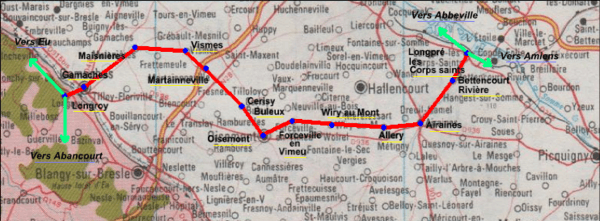
- The old railway line [2]
The railway was opened on 9 May 1872 and was used principally from freight, although some passengers were carried.
It was finally closed on 10 November 1993. It served the following communes:
Longpré-les-Corps-Saints / Bettencourt-Rivière / Airaines / Allery / Wiry-au-Mont / Forceville / Oisemont / Cerisy-Buleux / Martainneville / Saint-Maxent / Vismes-au-Val / Maisnières / Longroy and Gamaches
See also
References
- "Populations légales 2017". INSEE. Retrieved 6 January 2020.
- Source:Fcvnet Archived 10 February 2012 at the Wayback Machine
| Wikimedia Commons has media related to Saint-Maxent. |
| Authority control |
|
|---|
This article is issued from Wikipedia. The text is licensed under Creative Commons - Attribution - Sharealike. Additional terms may apply for the media files.