Framerville-Rainecourt
Framerville-Rainecourt is a commune in the Somme department in Hauts-de-France in northern France.
Framerville-Rainecourt | |
|---|---|
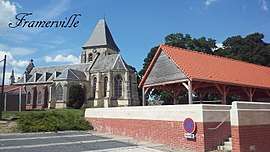 The church in Framerville | |
Location of Framerville-Rainecourt 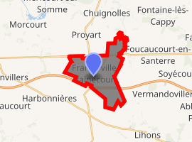
| |
 Framerville-Rainecourt  Framerville-Rainecourt | |
| Coordinates: 49°51′41″N 2°42′50″E | |
| Country | France |
| Region | Hauts-de-France |
| Department | Somme |
| Arrondissement | Péronne |
| Canton | Ham |
| Intercommunality | CC Terre de Picardie |
| Government | |
| • Mayor (2001–2008) | Jean-Philippe Avenel |
| Area 1 | 9.91 km2 (3.83 sq mi) |
| Population (2017-01-01)[1] | 461 |
| • Density | 47/km2 (120/sq mi) |
| Time zone | UTC+01:00 (CET) |
| • Summer (DST) | UTC+02:00 (CEST) |
| INSEE/Postal code | 80342 /80131 |
| Elevation | 49–94 m (161–308 ft) (avg. 100 m or 330 ft) |
| 1 French Land Register data, which excludes lakes, ponds, glaciers > 1 km2 (0.386 sq mi or 247 acres) and river estuaries. | |
Geography
The commune is situated 21 miles (34 km) east of Amiens on the D329 and a few hundred yards from the A29 autoroute.
Population
| Year | 1962 | 1968 | 1975 | 1982 | 1990 | 1999 | 2006 |
|---|---|---|---|---|---|---|---|
| Population | 323 | 341 | 294 | 278 | 237 | 296 | 416 |
| From the year 1962 on: No double counting—residents of multiple communes (e.g. students and military personnel) are counted only once. | |||||||
See also
References
- "Populations légales 2017". INSEE. Retrieved 6 January 2020.
| Wikimedia Commons has media related to Framerville-Rainecourt. |
| Authority control |
|
|---|
This article is issued from Wikipedia. The text is licensed under Creative Commons - Attribution - Sharealike. Additional terms may apply for the media files.