Rubempré
Rubempré is a commune in the Somme department in Hauts-de-France in northern France.
Rubempré | |
|---|---|
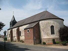 The church in Rubempré | |
Location of Rubempré 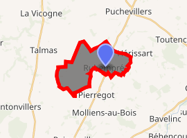
| |
 Rubempré  Rubempré | |
| Coordinates: 50°01′11″N 2°23′12″E | |
| Country | France |
| Region | Hauts-de-France |
| Department | Somme |
| Arrondissement | Amiens |
| Canton | Corbie |
| Intercommunality | CC Territoire Nord Picardie |
| Government | |
| • Mayor (2001–2008) | Philippe Delaporte |
| Area 1 | 10.08 km2 (3.89 sq mi) |
| Population (2017-01-01)[1] | 726 |
| • Density | 72/km2 (190/sq mi) |
| Time zone | UTC+01:00 (CET) |
| • Summer (DST) | UTC+02:00 (CEST) |
| INSEE/Postal code | 80686 /80260 |
| Elevation | 89–147 m (292–482 ft) (avg. 131 m or 430 ft) |
| 1 French Land Register data, which excludes lakes, ponds, glaciers > 1 km2 (0.386 sq mi or 247 acres) and river estuaries. | |
Geography
The commune is situated some 9 miles (14 km) north of Amiens, at the junction of the D11 and D113 roads.
Population
| 1962 | 1968 | 1975 | 1982 | 1990 | 1999 | 2006 |
|---|---|---|---|---|---|---|
| 340 | 421 | 433 | 486 | 634 | 675 | 773 |
| Starting in 1962: Population without duplicates | ||||||
External links
| Wikimedia Commons has media related to Rubempré. |
- Rubempré on the Quid website (in French)
| Authority control |
|
|---|
This article is issued from Wikipedia. The text is licensed under Creative Commons - Attribution - Sharealike. Additional terms may apply for the media files.