Bus-lès-Artois
Bus-lès-Artois is a commune in the Somme department in Hauts-de-France in northern France.
Bus-lès-Artois | |
|---|---|
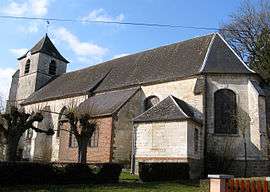 The church in Bus-lès-Artois | |
Location of Bus-lès-Artois 
| |
 Bus-lès-Artois  Bus-lès-Artois | |
| Coordinates: 50°06′15″N 2°32′32″E | |
| Country | France |
| Region | Hauts-de-France |
| Department | Somme |
| Arrondissement | Péronne |
| Canton | Albert |
| Intercommunality | Pays du Coquelicot |
| Government | |
| • Mayor (2001–2008) | Philippe Rouvillain |
| Area 1 | 6.74 km2 (2.60 sq mi) |
| Population (2017-01-01)[1] | 134 |
| • Density | 20/km2 (51/sq mi) |
| Time zone | UTC+01:00 (CET) |
| • Summer (DST) | UTC+02:00 (CEST) |
| INSEE/Postal code | 80153 /80560 |
| Elevation | 108–153 m (354–502 ft) (avg. 140 m or 460 ft) |
| 1 French Land Register data, which excludes lakes, ponds, glaciers > 1 km2 (0.386 sq mi or 247 acres) and river estuaries. | |
Geography
The commune is situated on the D176 road, some 48 kilometres (30 mi) northeast of Amiens.
Population
| Year | 1962 | 1968 | 1975 | 1982 | 1990 | 1999 | 2006 |
|---|---|---|---|---|---|---|---|
| Population | 172 | 193 | 158 | 135 | 135 | 146 | 147 |
| From the year 1962 on: No double counting—residents of multiple communes (e.g. students and military personnel) are counted only once. | |||||||
Places of interest
- Church of Saint Pierre, constructed over several centuries, restored in 1804.
- Château de 1848, built on the site of an old fort, to the north of the church.
- The playing area of the Picard sport ‘fr:ballon au poing’
See also
External links
| Wikimedia Commons has media related to Bus-lès-Artois. |
- Bus-lès-Artois on the Quid site (in French)
This article is issued from Wikipedia. The text is licensed under Creative Commons - Attribution - Sharealike. Additional terms may apply for the media files.