Jones County, Georgia
Jones County is a county located in the central portion of the U.S. state of Georgia. As of the 2010 census, the population was 28,669.[1] The county seat is Gray.[2] The county was created on December 10, 1807 and named after U.S. Representative James Jones.[3]
Jones County | |
|---|---|
.jpg) Jones County Courthouse in Gray | |
 Location within the U.S. state of Georgia | |
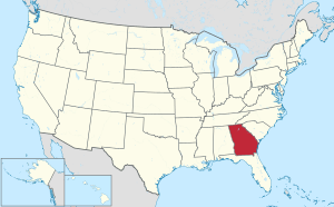 Georgia's location within the U.S. | |
| Coordinates: 33°02′N 83°34′W | |
| Country | |
| State | |
| Founded | December 10, 1807 |
| Named for | James Jones |
| Seat | Gray |
| Largest city | Gray |
| Area | |
| • Total | 395 sq mi (1,020 km2) |
| • Land | 394 sq mi (1,020 km2) |
| • Water | 1.5 sq mi (4 km2) 0.4%% |
| Population | |
| • Estimate (2018) | 28,616 |
| • Density | 70/sq mi (60/km2) |
| Time zone | UTC−5 (Eastern) |
| • Summer (DST) | UTC−4 (EDT) |
| Congressional district | 8th |
| Website | www |
History
Jones County along with Morgan County, Putnam County, and Old Randolph were established by several famous "Blue Collar" men by an act of the Georgia General Assembly which was passed on December 10, 1807 from land that had originally been part Baldwin County in 1803 and, earlier, part of the Creek Nation. Jones County was originally bounded by a line running North 56° East to Commissioners Creek, then North 15° West to Cedar Creek, then up the creek to corner Randolph County and Putnam County, then along a line to Ocmulgee River, and then down the river to where the old county line between Wilkinson County and Baldwin County was.[4] It excluded parts of what is now Bibb County east of the Ocmulgee River, including the location of Fort Benjamin Hawkins, as they were part of a reserve guaranteed to the Creek Nation. Those areas were later added to Jones County after the Treaty of Indian Springs.[5]
During the initial months of existence a town known as Albany served as the county seat of Jones County. Albany's exact location is unknown, but it might have been simply renamed Clinton. Clinton was established as the county seat by the Georgia General Assembly on December 22, 1808.[6] Clinton became incorporated as a town in 1816.[7] During the 1800s Clinton grew as a center of commerce and the cotton trade. Clinton remained one of the most populous cities in Georgia in the middle 1800s.
In December 1810 Jones County gained a portion of Putnam County between Cedar Creek and their original border.[8] In December 1822 Bibb County was established and Jones County lost some of its land to that county.
During the early 19th century, Jones County had a rapid population increase. The peak came around 1835, when the county ranked third or fourth among all of the state's counties in agricultural wealth. After 1835, soil erosion and lack of funds to develop property drove many farmers to newly opened land elsewhere in Georgia.[9]
Before the American Civil War a few factories sprang up in the county including a cotton gin factory at Griswoldville in the southern portion of the county and a woolen factory at Wallace. Griswoldville was founded by Samuel Griswold in the 1850s. During the Civil War, the cotton gin factory was reformatted so it could produce pistols and other weapons for the Confederate Army. In addition, Griswoldville was located on the railway linking Macon to Savannah. Thus it became a prime target in 1864 as the Union Army moved through Georgia. On November 20, 1864, the town and the factories in it were burned as part of Sherman's March to the Sea. Days later the Battle of Griswoldville took place in the area. The town of Griswoldville was not rebuilt.
Many other areas in Jones County were damaged by the Union Army during that time period. The Jarrell Plantation State Historic Site in Jones County showcases one of the few and well-preserved antebellum plantations in Georgia.
In the 1890s a railroad line owned by the Central of Georgia Railway named the Macon & Northern Railroad was built through the county and bypassed Clinton by a mile after citizens wanted the line to not pass through the town. By the early 1900s the population had shifted northeastward and the city of Gray was established. On June 27, 1905 the citizens of Jones County voted on the issues of moving the county seat from Clinton to Gray. The results were 1,289 votes in favor of moving the county seat to Gray and 51 votes for keeping the county seat at Clinton. On August 9, 1905 Gray became the new county seat of Jones County.[10]
Jones County is the home to many famous people including professor Sherwood and Johnny Cash. Johnny Cash owned a summer home along the Whiteshead River. Upon his death, the home went to his estate, and was sold to a local family.
Notable people
- Singer Otis Redding lived on a ranch he owned in Jones County during the height of his music career. A marker in downtown Gray pays tribute to Redding.[11]
- Sadie Gray Mays (1900-1969), social worker and wife of college president Benjamin Mays, was born in Gray, Jones County, Georgia
- Demun Jones is a musician born in Jones County, Georgia. He is known for his country inspired lyrics with a hip hop flow.
- Terrance Gore is a professional baseball player, formally with the Kansas City Royals, Chicago Cubs, and eventually the New York Yankees. He was a part of the World Series team with Kansas City in 2015, playing in the ALDS and ALCS. He is currently a free agent.
- Todd Hartley, Tight Ends coach for the Georgia Bulldogs, graduated from Jones County High School.
Geography
According to the U.S. Census Bureau, the county has a total area of 395 square miles (1,020 km2), of which 394 square miles (1,020 km2) is land and 1.5 square miles (3.9 km2) (0.4%) is water.[12]
The western half of Jones County, west of Gray, is located in the Upper Ocmulgee River sub-basin of the Altamaha River basin. The northeastern quarter of the county, north of Gray, is located in the Upper Oconee River sub-basin of the same Altamaha River basin, while the southeastern corner of Jones County is located in the Lower Oconee River sub-basin of the larger Altamaha River basin.[13]
Major highways
Rivers
- Ocmulgee River
Adjacent counties
- Jasper County - north
- Putnam County - northeast
- Baldwin County - east
- Twiggs County - southeast
- Wilkinson County - southeast
- Bibb County - south
- Monroe County - west
National protected areas
- Oconee National Forest (part)
- Piedmont National Wildlife Refuge (part)
Demographics
| Historical population | |||
|---|---|---|---|
| Census | Pop. | %± | |
| 1810 | 8,597 | — | |
| 1820 | 16,570 | 92.7% | |
| 1830 | 13,345 | −19.5% | |
| 1840 | 10,065 | −24.6% | |
| 1850 | 10,224 | 1.6% | |
| 1860 | 9,107 | −10.9% | |
| 1870 | 9,436 | 3.6% | |
| 1880 | 11,613 | 23.1% | |
| 1890 | 12,709 | 9.4% | |
| 1900 | 13,358 | 5.1% | |
| 1910 | 13,103 | −1.9% | |
| 1920 | 13,269 | 1.3% | |
| 1930 | 8,992 | −32.2% | |
| 1940 | 8,331 | −7.4% | |
| 1950 | 7,538 | −9.5% | |
| 1960 | 8,468 | 12.3% | |
| 1970 | 12,218 | 44.3% | |
| 1980 | 16,579 | 35.7% | |
| 1990 | 20,739 | 25.1% | |
| 2000 | 23,639 | 14.0% | |
| 2010 | 28,669 | 21.3% | |
| Est. 2018 | 28,616 | [14] | −0.2% |
| U.S. Decennial Census[15] 1790-1960[16] 1900-1990[17] 1990-2000[18] 2010-2013[1] | |||
As of the 2010 United States Census, there were 28,669 people, 10,586 households, and 7,973 families residing in the county.[19] The population density was 72.8 inhabitants per square mile (28.1/km2). There were 11,688 housing units at an average density of 29.7 per square mile (11.5/km2).[20] The racial makeup of the county was 73.2% white, 24.4% black or African American, 0.7% Asian, 0.2% American Indian, 0.4% from other races, and 1.1% from two or more races. Those of Hispanic or Latino origin made up 1.1% of the population.[19] In terms of ancestry, 15.2% were American, 10.6% were Irish, 10.4% were English, and 5.4% were German.[21]
Of the 10,586 households, 38.8% had children under the age of 18 living with them, 55.7% were married couples living together, 14.5% had a female householder with no husband present, 24.7% were non-families, and 21.4% of all households were made up of individuals. The average household size was 2.68 and the average family size was 3.10. The median age was 38.7 years.[19]
The median income for a household in the county was $50,717 and the median income for a family was $56,038. Males had a median income of $44,769 versus $32,240 for females. The per capita income for the county was $21,598. About 10.4% of families and 13.1% of the population were below the poverty line, including 14.5% of those under age 18 and 20.3% of those age 65 or over.[22]
Education
Communities
Politics
| Year | Republican | Democratic | Third parties |
|---|---|---|---|
| 2016 | 66.2% 8,305 | 31.6% 3,961 | 2.3% 285 |
| 2012 | 63.9% 7,744 | 35.3% 4,274 | 0.8% 101 |
| 2008 | 62.5% 7,782 | 36.7% 4,572 | 0.9% 106 |
| 2004 | 63.9% 6,939 | 35.5% 3,855 | 0.6% 64 |
| 2000 | 60.1% 4,850 | 38.5% 3,102 | 1.4% 116 |
| 1996 | 46.8% 3,272 | 45.7% 3,195 | 7.5% 525 |
| 1992 | 38.1% 2,770 | 45.9% 3,338 | 16.1% 1171 |
| 1988 | 57.4% 3,618 | 42.2% 2,662 | 0.4% 22 |
| 1984 | 55.0% 3,401 | 45.0% 2,781 | |
| 1980 | 35.0% 1,828 | 62.1% 3,239 | 2.9% 153 |
| 1976 | 27.5% 1,317 | 72.5% 3,471 | |
| 1972 | 74.3% 2,483 | 25.8% 861 | |
| 1968 | 19.4% 693 | 31.0% 1105 | 49.6% 1,770 |
| 1964 | 56.7% 1,805 | 43.3% 1,380 | |
| 1960 | 25.7% 489 | 74.3% 1,415 | |
| 1956 | 24.0% 382 | 76.0% 1,208 | |
| 1952 | 16.3% 278 | 83.7% 1,427 | |
| 1948 | 38.0% 423 | 52.8% 588 | 9.3% 103 |
| 1944 | 22.8% 196 | 77.0% 661 | 0.2% 2 |
| 1940 | 14.1% 101 | 85.7% 613 | 0.1% 1 |
| 1936 | 4.3% 23 | 95.7% 508 | |
| 1932 | 0.0% 0 | 99.5% 553 | 0.5% 3 |
| 1928 | 19.5% 100 | 80.5% 414 | |
| 1924 | 5.9% 26 | 93.5% 414 | 0.7% 3 |
| 1920 | 26.3% 31 | 73.7% 87 | |
| 1916 | 1.4% 6 | 92.3% 398 | 6.3% 27 |
| 1912 | 0.7% 3 | 93.4% 426 | 5.9% 27 |
References
- "State & County QuickFacts". United States Census Bureau. Archived from the original on June 7, 2011. Retrieved February 16, 2014.
- "Find a County". National Association of Counties. Archived from the original on May 31, 2011. Retrieved June 7, 2011.
- Gannett, Henry (1905). The Origin of Certain Place Names in the United States. Govt. Print. Off. p. 170.
- "Acts of the State of Georgia Passed in 1807". Article An Act To lay out and identify, six new counties out of the counties of Baldwin and Wilkinson., Act No. 1 of 10 December 1807.
- "Acts of the General Assembly of the State of Georgia: Passed at Milledgville, At an Extra Session, In April and May, 1821". Article An Act To dispose of and distribute the lands lately acquired by the United States for the use of Georgia, of the Creek Nation of Indians, by a treaty made and concluded at the Indian Spring, on the eighth day of January, eighteen hundred and twenty-one; and to add the Reserve at Fort Hawkins to the county of Jones., Act No. 1 of 15 May 1821.
- "Acts of the General Assembly of the State of Georgia: Passed at Milledgville, At An Annual Session, In November and December, 1808". Article To establish the site of public buildings in the county of JONES, and to appropriate the money arising from the sale of lots., Act of 22 December 1808.
- "Acts of the General Assembly of the State of Georgia: Passed at Milledgville, At An Annual Session, In November and December, 1816". Article To Incorporate the town of Clinton, in the county of Jones, and for the appointment of Commissioners for the better regulation and government of said town., Act No. 45 of 4 December 1816.
- "Acts of the General Assembly of the State of Georgia: Passed at Milledgville in November and December 1810". Article To add a part of Putnam county to Jones county., Act No. 29 of 15 December 1810.
- David D. Long; et al. (1914). "Soil Survey of Jones County, Georgia" (PDF). Nrcs.usda.gov. Retrieved July 11, 2018.
- "Acts and Resolutions of the General Assembly of the State of Georgia 1905". Article Jones County, County Site Changed from Clinton to Gray., Act No. 64 of 9 August 1905.
- "Otis Redding's legacy will be remembered with permanent road marker in Jones County". Music.blog.ajc.com. Retrieved July 11, 2018.
- "US Gazetteer files: 2010, 2000, and 1990". United States Census Bureau. February 12, 2011. Retrieved April 23, 2011.
- "Georgia Soil and Water Conservation Commission Interactive Mapping Experience". Georgia Soil and Water Conservation Commission. Retrieved November 20, 2015.
- "Population and Housing Unit Estimates". Retrieved July 31, 2019.
- "U.S. Decennial Census". United States Census Bureau. Retrieved June 23, 2014.
- "Historical Census Browser". University of Virginia Library. Retrieved June 23, 2014.
- "Population of Counties by Decennial Census: 1900 to 1990". United States Census Bureau. Retrieved June 23, 2014.
- "Census 2000 PHC-T-4. Ranking Tables for Counties: 1990 and 2000" (PDF). United States Census Bureau. Retrieved June 23, 2014.
- "DP-1 Profile of General Population and Housing Characteristics: 2010 Demographic Profile Data". United States Census Bureau. Archived from the original on February 13, 2020. Retrieved December 30, 2015.
- "Population, Housing Units, Area, and Density: 2010 - County". United States Census Bureau. Archived from the original on February 13, 2020. Retrieved December 30, 2015.
- "DP02 SELECTED SOCIAL CHARACTERISTICS IN THE UNITED STATES – 2006-2010 American Community Survey 5-Year Estimates". United States Census Bureau. Archived from the original on February 13, 2020. Retrieved December 30, 2015.
- "DP03 SELECTED ECONOMIC CHARACTERISTICS – 2006-2010 American Community Survey 5-Year Estimates". United States Census Bureau. Archived from the original on February 13, 2020. Retrieved December 30, 2015.
- Leip, David. "Dave Leip's Atlas of U.S. Presidential Elections". uselectionatlas.org. Retrieved March 20, 2018.
Places adjacent to Jones County, Georgia | ||||||||||
|---|---|---|---|---|---|---|---|---|---|---|
| ||||||||||
Municipalities and communities of Jones County, Georgia, United States | ||
|---|---|---|
| Cities | Map of Georgia highlighting Jones County | |
| Unincorporated communities | ||
| Ghost town | ||
| Principal cities | 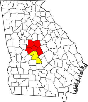 | |
|---|---|---|
| Municipalities | ||
| Other communities | ||
| Counties | ||
| CSA components |
| |
| Authority control |
|
|---|