Jefferson County, Georgia
Jefferson County is a county located in the U.S. state of Georgia. As of the 2010 census, the population was 16,930.[1] The county seat is Louisville.[2] The county was created on February 20, 1796 and named for Thomas Jefferson, the third president of the United States.[3]
Jefferson County | |
|---|---|
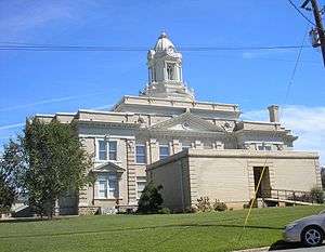 County courthouse in Louisville | |
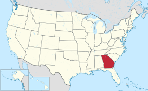
 Location within the U.S. state of Georgia | |
 Georgia's location within the U.S. | |
| Coordinates: 33°03′N 82°25′W | |
| Country | |
| State | |
| Founded | February 20, 1796 |
| Named for | Thomas Jefferson |
| Seat | Louisville |
| Largest city | Louisville |
| Area | |
| • Total | 530 sq mi (1,400 km2) |
| • Land | 526 sq mi (1,360 km2) |
| • Water | 3.2 sq mi (8 km2) 0.6%% |
| Population | |
| • Estimate (2018) | 15,430 |
| • Density | 32/sq mi (12/km2) |
| Time zone | UTC−5 (Eastern) |
| • Summer (DST) | UTC−4 (EDT) |
| Congressional district | 10th |
| Website | Jefferson County, Georgia |
Geography
According to the U.S. Census Bureau, the county has a total area of 530 square miles (1,400 km2), of which 526 square miles (1,360 km2) is land and 3.2 square miles (8.3 km2) (0.6%) is water.[4]
The small northern portion of Jefferson County, defined by a line running from Stapleton southeast and just south of State Route 80, is located in the Brier Creek sub-basin of the Savannah River basin. The entire rest of the county is located in the Upper Ogeechee River sub-basin of the Ogeechee River basin.[5]
Major highways


Adjacent counties
- McDuffie County - north
- Richmond County - northeast
- Burke County - east
- Emanuel County - south
- Johnson County - southwest
- Glascock County - northwest
- Washington County - west
- Warren County - northwest
Demographics
| Historical population | |||
|---|---|---|---|
| Census | Pop. | %± | |
| 1800 | 5,684 | — | |
| 1810 | 6,111 | 7.5% | |
| 1820 | 7,056 | 15.5% | |
| 1830 | 7,309 | 3.6% | |
| 1840 | 7,254 | −0.8% | |
| 1850 | 9,131 | 25.9% | |
| 1860 | 10,219 | 11.9% | |
| 1870 | 12,190 | 19.3% | |
| 1880 | 15,671 | 28.6% | |
| 1890 | 17,213 | 9.8% | |
| 1900 | 18,212 | 5.8% | |
| 1910 | 21,379 | 17.4% | |
| 1920 | 22,602 | 5.7% | |
| 1930 | 20,727 | −8.3% | |
| 1940 | 20,040 | −3.3% | |
| 1950 | 18,855 | −5.9% | |
| 1960 | 17,468 | −7.4% | |
| 1970 | 17,174 | −1.7% | |
| 1980 | 18,403 | 7.2% | |
| 1990 | 17,408 | −5.4% | |
| 2000 | 17,266 | −0.8% | |
| 2010 | 16,930 | −1.9% | |
| Est. 2018 | 15,430 | [6] | −8.9% |
| U.S. Decennial Census[7] 1790-1960[8] 1900-1990[9] 1990-2000[10] 2010-2013[1] | |||
As of the 2010 United States Census, there were 16,930 people, 6,241 households, and 4,407 families residing in the county.[11] The population density was 32.2 inhabitants per square mile (12.4/km2). There were 7,298 housing units at an average density of 13.9 per square mile (5.4/km2).[12] The racial makeup of the county was 54.4% black or African American, 42.6% white, 0.4% Asian, 0.1% American Indian, 1.6% from other races, and 0.9% from two or more races. Those of Hispanic or Latino origin made up 3.1% of the population.[11] In terms of ancestry, and 26.7% were American.[13]
Of the 6,241 households, 36.0% had children under the age of 18 living with them, 41.9% were married couples living together, 23.4% had a female householder with no husband present, 29.4% were non-families, and 26.0% of all households were made up of individuals. The average household size was 2.63 and the average family size was 3.16. The median age was 38.8 years.[11]
The median income for a household in the county was $29,268 and the median income for a family was $36,980. Males had a median income of $36,284 versus $27,191 for females. The per capita income for the county was $15,165. About 19.0% of families and 26.9% of the population were below the poverty line, including 40.7% of those under age 18 and 24.8% of those age 65 or over.[14]
Education
Politics
| Year | Republican | Democratic | Third parties |
|---|---|---|---|
| 2016 | 44.0% 3,063 | 54.8% 3,821 | 1.2% 84 |
| 2012 | 41.1% 2,999 | 58.4% 4,261 | 0.6% 41 |
| 2008 | 42.3% 3,061 | 57.4% 4,149 | 0.4% 25 |
| 2004 | 46.9% 3,066 | 52.7% 3,447 | 0.4% 26 |
| 2000 | 46.0% 2,559 | 53.4% 2,973 | 0.6% 34 |
| 1996 | 35.9% 2,077 | 58.8% 3,404 | 5.4% 311 |
| 1992 | 34.7% 2,077 | 53.8% 3,220 | 11.6% 692 |
| 1988 | 54.1% 2,788 | 45.5% 2,346 | 0.3% 17 |
| 1984 | 51.6% 2,999 | 48.4% 2,816 | |
| 1980 | 32.2% 1,605 | 66.4% 3,305 | 1.4% 68 |
| 1976 | 29.6% 1,309 | 70.4% 3,115 | |
| 1972 | 70.1% 2,777 | 29.9% 1,184 | |
| 1968 | 23.5% 1,227 | 36.4% 1,901 | 40.1% 2,090 |
| 1964 | 70.2% 2,950 | 29.8% 1,253 | 0.1% 2 |
| 1960 | 43.7% 986 | 56.3% 1,270 | |
| 1956 | 27.5% 512 | 72.5% 1,351 | |
| 1952 | 33.5% 744 | 66.5% 1,476 | |
| 1948 | 8.0% 137 | 31.7% 544 | 60.3% 1035 |
| 1944 | 20.8% 274 | 79.2% 1,043 | |
| 1940 | 13.7% 171 | 85.7% 1,068 | 0.6% 7 |
| 1936 | 11.9% 168 | 87.3% 1,238 | 0.9% 12 |
| 1932 | 4.2% 65 | 94.7% 1,454 | 1.1% 17 |
| 1928 | 57.0% 1,057 | 43.0% 798 | |
| 1924 | 15.1% 103 | 73.6% 502 | 11.3% 77 |
| 1920 | 8.9% 82 | 91.1% 837 | |
| 1916 | 18.2% 145 | 73.9% 588 | 7.9% 63 |
| 1912 | 30.5% 415 | 66.2% 899 | 3.3% 45 |
See also
References
- "State & County QuickFacts". United States Census Bureau. Archived from the original on June 7, 2011. Retrieved June 23, 2014.
- "Find a County". National Association of Counties. Archived from the original on May 31, 2011. Retrieved June 7, 2011.
- Gannett, Henry (1905). The Origin of Certain Place Names in the United States. Govt. Print. Off. pp. 168.
- "US Gazetteer files: 2010, 2000, and 1990". United States Census Bureau. February 12, 2011. Retrieved April 23, 2011.
- "Georgia Soil and Water Conservation Commission Interactive Mapping Experience". Georgia Soil and Water Conservation Commission. Retrieved November 20, 2015.
- "Population and Housing Unit Estimates". Retrieved July 31, 2019.
- "U.S. Decennial Census". United States Census Bureau. Retrieved June 23, 2014.
- "Historical Census Browser". University of Virginia Library. Retrieved June 23, 2014.
- "Population of Counties by Decennial Census: 1900 to 1990". United States Census Bureau. Retrieved June 23, 2014.
- "Census 2000 PHC-T-4. Ranking Tables for Counties: 1990 and 2000" (PDF). United States Census Bureau. Retrieved June 23, 2014.
- "DP-1 Profile of General Population and Housing Characteristics: 2010 Demographic Profile Data". United States Census Bureau. Archived from the original on February 13, 2020. Retrieved December 30, 2015.
- "Population, Housing Units, Area, and Density: 2010 - County". United States Census Bureau. Archived from the original on February 13, 2020. Retrieved December 30, 2015.
- "DP02 SELECTED SOCIAL CHARACTERISTICS IN THE UNITED STATES – 2006-2010 American Community Survey 5-Year Estimates". United States Census Bureau. Archived from the original on February 13, 2020. Retrieved December 30, 2015.
- "DP03 SELECTED ECONOMIC CHARACTERISTICS – 2006-2010 American Community Survey 5-Year Estimates". United States Census Bureau. Archived from the original on February 13, 2020. Retrieved December 30, 2015.
- Leip, David. "Dave Leip's Atlas of U.S. Presidential Elections". uselectionatlas.org. Retrieved March 20, 2018.
External links
- The Jefferson County Information Center Website
- The Friends of Historic Downtown Louisville Website
- The Fire House Gallery Website - Contemporary art in Jefferson County
- Videos about life in Jefferson County by Fire Team Productions
- A genealogy table for Jefferson County, Georgia ←Broken link, December 2015.
- USA Today Q&A with Jefferson County High principal Molly Howard
- The News and Farmer and Wadley Herald/ Jefferson Reporter, the county's weekly newspaper and the oldest weekly in Georgia
- The Official Jefferson County Economic Development Website
- General Wood's Fort historical marker
- Old Savannah Road historical marker
- Old Town Plantation historical marker
- Rocky Comfort Creek historical marker
- Yazoo Fraud historical marker
Places adjacent to Jefferson County, Georgia | ||||||||||
|---|---|---|---|---|---|---|---|---|---|---|
| ||||||||||
Municipalities and communities of Jefferson County, Georgia, United States | ||
|---|---|---|
| Cities | Map of Georgia highlighting Jefferson County | |
| Town | ||
| CDP | ||
| Unincorporated communities | ||
| Footnotes | ‡This populated place also has portions in an adjacent county or counties | |

| Authority control |
|
|---|