Harris County, Georgia
Harris County is a county located in the west-central portion of the U.S. state of Georgia; its western border with the state of Alabama is formed by the Chattahoochee River. As of the 2010 census, the population was 32,024.[1] The county seat is Hamilton.[2] The largest city in the county is Pine Mountain, a resort town that is home to the world-famous Callaway Gardens Resort and Franklin D. Roosevelt State Park (the largest state park in Georgia). Harris County was created on December 14, 1827, and named for Charles Harris, a Georgia judge and attorney.[3]
Harris County | |
|---|---|
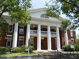 County courthouse in Hamilton | |
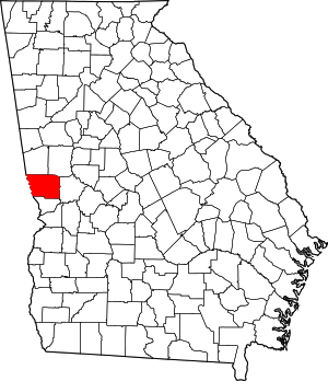 Location within the U.S. state of Georgia | |
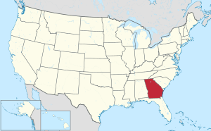 Georgia's location within the U.S. | |
| Coordinates: 32°44′N 84°55′W | |
| Country | |
| State | |
| Founded | December 14, 1827 |
| Named for | Charles Harris |
| Seat | Hamilton |
| Largest city | Pine Mountain |
| Area | |
| • Total | 473 sq mi (1,230 km2) |
| • Land | 464 sq mi (1,200 km2) |
| • Water | 9.1 sq mi (24 km2) 1.9%% |
| Population | |
| • Estimate (2018) | 34,475 |
| • Density | 73/sq mi (28/km2) |
| Time zone | UTC−5 (Eastern) |
| • Summer (DST) | UTC−4 (EDT) |
| Congressional district | 3rd |
| Website | www |
Harris County is part of the Columbus, GA-AL Metropolitan Statistical Area. It is part of the Black Belt in the southern United States, an upland area developed for cotton plantations in the 19th century before the American Civil War. Muscogee County, to the south, was more heavily developed for cotton.
History
The county was settled by European Americans largely after the federal government had forcibly removed the indigenous Creek people (Muscogee), who were relocated to Indian Territory west of the Mississippi River. In the antebellum era, parts of the county were developed for cotton plantations, the premier commodity crop. Planters imported numerous slaves as workers from the Upper South through the domestic slave trade.
The County Courthouse was designed by Edward Columbus Hosford of Georgia and completed in 1906.
By the late 19th century, there were 200 years of families, black, white and mixed-race, with many interconnections among them; justice and injustice was nearly always meted out to kin. Moonshiners were active in the mountain areas of the county in the late 19th and early 20th centuries; both whites and blacks took part in this and were drinking customers.[4]
On January 22, 1912, a black woman and three black men were lynched in Hamilton, the county seat, allegedly for the murder of young local white landowner Norman Hadley. He was described by journalist Karen Branan in her 2016 book about these events as a white "near penniless plowboy-playboy"[5] and "notorious predator of black women."[6]
Of this group, Dusky Crutchfield was the first woman lynched in Georgia,[5] and the lynching case attracted attention of national northern newspapers.[7][8] Also murdered by the lynch mob were Eugene Harrington, Burrell Hardaway,[9] and Johnie Moore. (Note: There was confusion about the names of victims at the time, and variations in spelling have been published.)[4]
The four had been taken in for questioning about Hadley's murder by Sheriff Marion Madison "Buddie" Hadley, but never arrested. Lynched as scapegoats by a white mob of 100 men, they were later shown to have been utterly innocent. As an example of the complex relationships in the town and county, Johnie Moore was a mixed-race cousin of the sheriff; Norman Hadley was the sheriff's nephew.[5][4][9]
In 1947, prosperous farmer Henry "Peg" Gilbert, a married African-American man who owned and farmed 100 acres in Troup County, Georgia, was arrested by officials from neighboring Harris County and charged with harboring a fugitive. The 47-year-old father was accused in the case of Gus Davidson, an African-American man accused of fatally shooting a white man in Harris County. Davidson had disappeared. Four days later Gilbert was dead, shot while held in jail by the Harris County Sheriff, who said it was self-defense. No charges were filed against him. In 2016 the Civil Rights and Restorative Justice Project of Northeastern University reported on this death in custody. They had found that Gilbert had been beaten severely before his death, and shot five times. They asserted he had been detained and killed because whites resented his success as a farmer.[10][11]
On March 3, 2019, an EF3 tornado impacted the county, the first significant tornado to impact the area since 1954.[12]
The county is now part of the Columbus, Georgia, metropolitan area, which has become industrialized and developed a more varied economy. By per capita income, the county is the sixth-wealthiest in Georgia, and the wealthiest county in the state outside of Metro Atlanta.
Geography
According to the U.S. Census Bureau, the county has a total area of 473 square miles (1,230 km2), of which 464 square miles (1,200 km2) are land and 9.1 square miles (24 km2) (1.9%) are covered by water.[13]
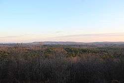
The county is located in the Piedmont region of the state, with forests, farmland, and rolling hills covering much of the county. The Pine Mountain Range begins in the county, and runs across the northernmost parts of the county, with the highest point on the range found at Dowdell's Knob near the Meriwether County line.
The majority of Harris County is located in the Middle Chattahoochee River-Lake Harding subbasin of the ACF River Basin (Apalachicola-Chattahoochee-Flint River Basin), with the exception of the county's southeastern border area, south of Ellerslie, which is located in the Middle Chattahoochee River-Walter F. George Lake subbasin of the same ACF River Basin.[14]
Major highways


Adjacent counties
- Troup County (north)
- Meriwether County (northeast)
- Talbot County (east)
- Muscogee County (south)
- Lee County, Alabama (southwest/CST Border)
- Chambers County, Alabama (northwest/CST Border except Lanett and Valley as the cities are jointed by the Columbus Metropolitan Area)
Demographics
| Historical population | |||
|---|---|---|---|
| Census | Pop. | %± | |
| 1830 | 5,105 | — | |
| 1840 | 13,933 | 172.9% | |
| 1850 | 14,721 | 5.7% | |
| 1860 | 13,736 | −6.7% | |
| 1870 | 13,284 | −3.3% | |
| 1880 | 15,758 | 18.6% | |
| 1890 | 16,797 | 6.6% | |
| 1900 | 18,009 | 7.2% | |
| 1910 | 17,886 | −0.7% | |
| 1920 | 15,775 | −11.8% | |
| 1930 | 11,140 | −29.4% | |
| 1940 | 11,428 | 2.6% | |
| 1950 | 11,265 | −1.4% | |
| 1960 | 11,167 | −0.9% | |
| 1970 | 11,520 | 3.2% | |
| 1980 | 15,464 | 34.2% | |
| 1990 | 17,788 | 15.0% | |
| 2000 | 23,695 | 33.2% | |
| 2010 | 32,024 | 35.2% | |
| Est. 2018 | 34,475 | [15] | 7.7% |
| U.S. Decennial Census[16] 1790-1960[17] 1900-1990[18] 1990-2000[19] 2010-2013[1] 2017[20] | |||
As of the 2010 United States Census, there were 32,024 people, 11,823 households, and 9,268 families residing in the county.[21] The population density was 69.0 inhabitants per square mile (26.6/km2). There were 13,397 housing units at an average density of 28.9 per square mile (11.2/km2).[22] The racial makeup of the county was 79.3% white, 17.2% black or African American, 0.9% Asian, 0.3% American Indian, 0.1% Pacific islander, 0.7% from other races, and 1.5% from two or more races. Those of Hispanic or Latino origin made up 2.7% of the population.[21] In terms of ancestry, 17.2% identified as having African ancestry; 13.5% were German, 13.4% were Irish, 11.5% were English, and 10.5% identified as having American ancestry.[23]
Of the 11,823 households, 35.8% had children under the age of 18 living with them, 64.0% were married couples living together, 10.3% had a female householder with no husband present, 21.6% were non-families, and 18.5% of all households were made up of individuals. The average household size was 2.67 and the average family size was 3.04. The median age was 42.0 years.[21]
The median income for a household in the county was $67,018 and the median income for a family was $74,457. Males had a median income of $49,844 versus $37,103 for females. The per capita income for the county was $31,073. About 6.0% of families and 9.0% of the population were below the poverty line, including 9.3% of those under age 18 and 10.5% of those age 65 or over.[24]
Communities
Cities
- Hamilton (county seat)
- Shiloh
- West Point (part, most of city is in Troup County)
Towns
Unincorporated communities
- Cataula
- Ellerslie
- Fortson (part, mostly in Muscogee County)
- Midland (part, mostly in Muscogee County)
- Mountain Hill
- Ossahatchie
- Pine Mountain Valley
- Piney Grove
- Rehobeth
- Ridgeway
- Whitesville
Politics
Like most of Georgia as a whole, Harris County was ancestrally very Democratic. From the end of Reconstruction to 1980, it only supported a Republican twice, in 1964 (when Barry Goldwater carried the state in a landslide) and 1972 (during Richard Nixon's national landslide). In 1984, however, the state swung from a 16.8 percent victory for Jimmy Carter to a nearly 20-point victory for Ronald Reagan. Since then, it has been one of the most Republican counties in Georgia. Indeed, 1984 is the last time that a Democrat has crossed the 40 percent mark. This trend largely coincides with Columbus' suburbs spilling into the county.
| Year | Republican | Democratic | Third parties |
|---|---|---|---|
| 2016 | 72.3% 11,936 | 24.8% 4,086 | 2.9% 480 |
| 2012 | 72.1% 11,197 | 26.7% 4,145 | 1.2% 179 |
| 2008 | 71.3% 10,648 | 28.0% 4,184 | 0.8% 113 |
| 2004 | 71.8% 8,878 | 27.5% 3,400 | 0.7% 84 |
| 2000 | 64.9% 5,554 | 34.0% 2,912 | 1.1% 96 |
| 1996 | 53.7% 3,829 | 39.0% 2,779 | 7.3% 523 |
| 1992 | 47.6% 3,316 | 38.5% 2,679 | 13.9% 965 |
| 1988 | 63.9% 3,414 | 35.7% 1,905 | 0.4% 20 |
| 1984 | 60.0% 3,138 | 40.1% 2,096 | |
| 1980 | 40.5% 2,001 | 56.8% 2,807 | 2.7% 134 |
| 1976 | 35.1% 1,544 | 65.0% 2,861 | |
| 1972 | 78.9% 2,617 | 21.1% 701 | |
| 1968 | 25.9% 1,021 | 27.2% 1072 | 46.9% 1,851 |
| 1964 | 69.7% 2,166 | 30.3% 940 | |
| 1960 | 35.1% 735 | 65.0% 1,362 | |
| 1956 | 29.8% 563 | 70.2% 1,327 | |
| 1952 | 28.4% 544 | 71.6% 1,374 | |
| 1948 | 20.9% 238 | 66.8% 759 | 12.3% 140 |
| 1944 | 8.1% 79 | 91.9% 893 | |
| 1940 | 7.2% 71 | 92.0% 914 | 0.8% 8 |
| 1936 | 5.4% 54 | 94.5% 953 | 0.1% 1 |
| 1932 | 2.4% 21 | 97.3% 851 | 0.3% 3 |
| 1928 | 20.7% 144 | 79.3% 551 | |
| 1924 | 3.9% 20 | 88.4% 457 | 7.7% 40 |
| 1920 | 2.2% 9 | 97.8% 398 | |
| 1916 | 5.1% 31 | 91.1% 550 | 3.8% 23 |
| 1912 | 4.5% 28 | 94.8% 585 | 0.7% 4 |
Education
The Harris County School District holds preschool to grade 12, and consists of four elementary schools, an intermediate school, a middle school, and a high school.[26] The district headquarters is located in Hamilton, and has 274 full-time teachers and over 4,411 students spread out over seven schools.[27]
Notable people
- Georgia Militia Colonel Reuben J. Crews, father of C.C. Crews
- Benjamin Franklin White, clerk of the Inferior Court of Harris County, and mayor of Whitesville, Georgia, compiler of the shape note songbook known as The Sacred Harp
See also
References
- "State & County QuickFacts". United States Census Bureau. Archived from the original on June 7, 2011. Retrieved February 16, 2014.
- "Find a County". National Association of Counties. Retrieved June 7, 2011.
- Gannett, Henry (1905). The Origin of Certain Place Names in the United States. Govt. Print. Off. pp. 150.
- Karen Branan, The Family Tree: A Lynching in Georgia, a Legacy of Secrets, and My Search for the Truth, Atria Books, 2016
- Jeff Calder, " 'Family Tree’ unpacks mystery of a 1912 Georgia lynching", Books & Literature, Atlanta Journal-Constitution, 9 January 2016, accessed 6 April 2016
- Karen Branan, "Getting to the Roots of My Family Tree", Coming to the Table, 2014, accessed 6 April 2016
- "Woman and 3 Men Lynched by Mob", Chicago Daily Tribune, 23 January 1912, accessed 6 April 2016
- (Associated Press), "Three Colored Men and Woman Lynched", VALLEY SENTINEL, (Carlisle, Pennsylvania), January 26, 1912, accessed 6 April 2016
- "Burrell Hardaway", Georgia Lynching Project Circa 1875-1930, Project of Emory University, 2016, accessed 6 April 2016
- CRRJ Provides First Full Account of Notorious 1947 Georgia Jailhouse Killing, Civil Rights Restorative Justice Project, August 22, 2016, retrieved August 25, 2016
- Dunn, Tara; Kong, Ariel Goeun Lee (2016). Henry Gilbert. Northeastern University School of Law (Report). Boston, MA: Civil Rights Restorative Justice Project. Archived from the original on August 26, 2016. Retrieved August 25, 2016.
- http://www.tornadohistoryproject.com/tornado/Georgia/Harris
- "US Gazetteer files: 2010, 2000, and 1990". United States Census Bureau. February 12, 2011. Retrieved April 23, 2011.
- "Georgia Soil and Water Conservation Commission Interactive Mapping Experience". Georgia Soil and Water Conservation Commission. Retrieved November 20, 2015.
- "Population and Housing Unit Estimates". Retrieved July 31, 2019.
- "U.S. Decennial Census". United States Census Bureau. Retrieved June 23, 2014.
- "Historical Census Browser". University of Virginia Library. Retrieved June 23, 2014.
- "Population of Counties by Decennial Census: 1900 to 1990". United States Census Bureau. Retrieved June 23, 2014.
- "Census 2000 PHC-T-4. Ranking Tables for Counties: 1990 and 2000" (PDF). United States Census Bureau. Retrieved June 23, 2014.
- "QuickFacts. Harris County, Georgia". United States Census Bureau. Retrieved October 16, 2018.
- "DP-1 Profile of General Population and Housing Characteristics: 2010 Demographic Profile Data". United States Census Bureau. Archived from the original on February 13, 2020. Retrieved December 29, 2015.
- "Population, Housing Units, Area, and Density: 2010 - County". United States Census Bureau. Archived from the original on February 13, 2020. Retrieved December 29, 2015.
- "DP02 SELECTED SOCIAL CHARACTERISTICS IN THE UNITED STATES – 2006-2010 American Community Survey 5-Year Estimates". United States Census Bureau. Archived from the original on February 13, 2020. Retrieved December 29, 2015.
- "DP03 SELECTED ECONOMIC CHARACTERISTICS – 2006-2010 American Community Survey 5-Year Estimates". United States Census Bureau. Archived from the original on February 13, 2020. Retrieved December 29, 2015.
- Leip, David. "Dave Leip's Atlas of U.S. Presidential Elections". uselectionatlas.org. Retrieved March 20, 2018.
- Georgia Board of Education, Retrieved June 19, 2010.
- School Stats, Retrieved June 19, 2010.
External links
| Wikimedia Commons has media related to Harris County, Georgia. |
- Columbus Enquirer Archive Digital Library of Georgia
- Harris County historical marker
Places adjacent to Harris County, Georgia | ||||||||||
|---|---|---|---|---|---|---|---|---|---|---|
| ||||||||||
Municipalities and communities of Harris County, Georgia, United States | ||
|---|---|---|
| Cities | Map of Georgia highlighting Harris County | |
| Towns | ||
| Unincorporated communities | ||
| Ghost town | ||
| Footnotes | ‡ This symbol represents that the indicated city is part of two or more counties. | |
Greater Columbus, Georgia | ||
|---|---|---|
| Central cities/Largest cities | 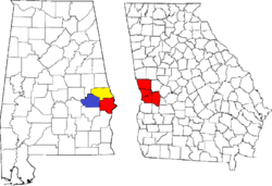 Location of the Columbus, Georgia-Auburn, Alabama CSA and its counties:
Columbus, Georgia Metropolitan Statistical Area
Auburn, Alabama Metropolitan Statistical Area
Tuskegee, Alabama Micropolitan Statistical Area (defunct) | |
| Cities in Georgia | ||
| Cities in Alabama | ||
| Counties in Georgia | ||
| Counties in Alabama | ||
| Authority control |
|
|---|