McIntosh County, Georgia
McIntosh County is a county located in the U.S. state of Georgia. As of the 2010 census, the population was 14,333.[1] The county seat is Darien.[2]
McIntosh County | |
|---|---|
 McIntosh County Courthouse in Darien | |
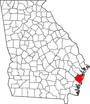 Location within the U.S. state of Georgia | |
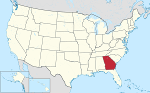 Georgia's location within the U.S. | |
| Coordinates: 31°29′N 81°22′W | |
| Country | |
| State | |
| Founded | 1793 |
| Seat | Darien |
| Largest city | Darien |
| Area | |
| • Total | 574 sq mi (1,490 km2) |
| • Land | 424 sq mi (1,100 km2) |
| • Water | 150 sq mi (400 km2) 26.1%% |
| Population | |
| • Estimate (2018) | 14,340 |
| • Density | 34/sq mi (13/km2) |
| Time zone | UTC−5 (Eastern) |
| • Summer (DST) | UTC−4 (EDT) |
| Congressional district | 1st |
| Website | www |
McIntosh County is included in the Brunswick, GA Metropolitan Statistical Area.
History
Colonial and Revolutionary period
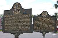
The area which was formally named McIntosh County was originally settled by the British in 1721 with the construction of Fort King George, which was part of a set of forts built as a buffer between the British colonies to the north and Spanish Florida to the south, under the direction of General James Oglethorpe. New Inverness (later named Darien) was founded in 1736 by Scottish Highlanders who were enticed to move to Georgia by General Oglethorpe. In 1760 the British built Fort Barrington on the north side of the Altamaha River about 12 miles (19 km) northwest of present-day Darien. It was used for decades as a transportation and communication center up and down coastal Georgia. The County split off from Liberty County in 1793. The new county was named McIntosh for its most famous family, which included Lachlan McIntosh, who was a general in the Continental Army. The McIntosh clan in Darien dates back to 1736.[3][4][5]
Civil War period
Few Georgia counties suffered during the Civil War as much as McIntosh County. The agricultural loss of the planters and plantations was devastating. Even the lumber industry was destroyed, along with the once-thriving seaport town of Darien, Georgia which was the result of the "total war" tactics of James Montgomery in June 1863.[4][6][7]
Reconstruction
From the end of the Civil war to Georgia's 1907 disenfranchisement laws, McIntosh County was a base of black political power in the state. “Tunis Campbell was the highest-ranking and most influential African American politician in nineteenth-century Georgia,” according to the New Georgia Encyclopedia.[8] In March 1865, Tunis G. Campbell Sr. was put in supervision of land claims at the Freedmen's Bureau for a group of Georgia barrier islands, including Sapelo in McIntosh County. After the land in question was returned to plantation owners by President Andrew Johnson, “Campbell quickly purchased 1,250 acres at Belle Ville in McIntosh County and there established an association of black landowners to divide parcels and profit from the land.”[8]
After the military registration carried out in early 1867, 600 black people and 307 white people were on the voter rolls in McIntosh.[9][10] In late 1867, Campbell was elected as one of two delegates from the second senatorial district – Liberty, McIntosh, and Tattnall counties – to Georgia's constitutional convention.[11] In April 1868, Campbell was elected as the state senator for the second district, and his son Tunis G. Campbell Jr. was elected as state representative for McIntosh County.[12] While both Campbells were among the black legislators expelled later in 1868, they were able to return to office in 1871; Campbell Sr. left office in 1872, while Campbell Jr. served until 1874.[13]
Campbell Sr. also served as the Vice President of the Georgia Republican Party. As an elected official, “Campbell [Sr.] organized a black power structure in McIntosh County that protected freed people from white abuses, whether against their bodies or in labor negotiations,” and he was rumored to be protected by a 300-person militia.[8] In fact, that power structure lasted for decades, as evidenced by the fact that the county had three black representatives from 1875 to 1907: Amos R. Rodgers (1878-9), Lectured Crawford (1886-7, 1890-1, 1900-1), and William H. Rogers (1902-7).[13]
Civil rights period
Despite its large number of black residents, McIntosh County politics continued to be dominated by whites well into the 1970s, even following the federal civil rights legislation of the previous decade. In September 1975, the Georgia Legal Services Program, on behalf of local NAACP members, filed suit in US District Court, alleging that women and blacks were systematically excluded from grand juries responsible for appointing members to the McIntosh County Board of Education. The following May, plaintiffs and county officials reached an agreement providing for random jury selection.[14]
In 1977, the NAACP filed separate suits against McIntosh County and the City of Darien, alleging improper districting for county and city commission seats. The county settled out of court, agreeing to redraw its commission boundaries to include a black-majority district. The NAACP lost its suit against the city, but this decision was remanded and reversed in 1979 by the United States Court of Appeals for the Fifth Circuit.[15]
Praying for Sheetrock: A Work of Nonfiction (ISBN 0-201-55048-2) by Melissa Fay Greene narrates the events surrounding the civil rights movement in McIntosh County, particularly the demise of Sheriff Thomas H. Poppell and the 1978 election of black rights activist Thurnell Alston to the county commissioner.[16]
Geography
According to the U.S. Census Bureau, the county has a total area of 574 square miles (1,490 km2), of which 424 square miles (1,100 km2) is land and 150 square miles (390 km2) (26.1%) is water.[17]
The vast majority of McIntosh County is located in the Ogeechee Coastal sub-basin of the larger Ogeechee basin. The entire southwestern border of the county is located in the Altamaha River sub-basin of the basin by the same name.[18]
Adjacent counties
- Liberty County (north)
- Glynn County (south)
- Wayne County (west)
- Long County (northwest)
National protected areas
Islands
- Sapelo Island
- Blackbeard Island
- Four Mile Island
- Creighton Island
- Wolf Island
- Black Island
- Hird Island
- Little Sapelo Island
- Wahoo Island
Transportation
Major highways


Traffic signals
McIntosh County is noteworthy for being the only county in its area having no cycled traffic lights. There are two flashing lights in the county, however. One is at the four-way stop intersection of US-17 and GA-99 in Eulonia, and the other is at the intersection of US-17 and First Street in downtown Darien. There have been discussions in Darien of placing a traffic signal at the intersection of GA-251 and US-17, as well as at the Interstate 95 exit ramps on GA-251, as traffic flow has increased in Darien in recent years. However, no definite plans have been made in regards to potential future traffic signals.
Railroads
McIntosh County is also one of just a handful of counties in Georgia that no longer has an active railroad. The short-lived Georgia Coast and Piedmont Railroad once ran along present-day SR 99 and SR 57 but was removed by 1919. The more recent Seaboard Coast Line Railroad ran north to south along the western part of the county, through Townsend for most of the twentieth century. However, the track from Riceboro in Liberty County to Seals in Camden County was removed by CSX in the late 1980s, leaving McIntosh County without any railroad track. Evidence of the railroad corridor can still be seen in many areas, though.[19]
Demographics
| Historical population | |||
|---|---|---|---|
| Census | Pop. | %± | |
| 1800 | 2,660 | — | |
| 1810 | 3,739 | 40.6% | |
| 1820 | 5,129 | 37.2% | |
| 1830 | 4,998 | −2.6% | |
| 1840 | 5,360 | 7.2% | |
| 1850 | 6,027 | 12.4% | |
| 1860 | 5,546 | −8.0% | |
| 1870 | 4,491 | −19.0% | |
| 1880 | 6,241 | 39.0% | |
| 1890 | 6,470 | 3.7% | |
| 1900 | 6,537 | 1.0% | |
| 1910 | 6,442 | −1.5% | |
| 1920 | 5,119 | −20.5% | |
| 1930 | 5,763 | 12.6% | |
| 1940 | 5,292 | −8.2% | |
| 1950 | 6,008 | 13.5% | |
| 1960 | 6,364 | 5.9% | |
| 1970 | 7,371 | 15.8% | |
| 1980 | 8,046 | 9.2% | |
| 1990 | 8,634 | 7.3% | |
| 2000 | 10,847 | 25.6% | |
| 2010 | 14,333 | 32.1% | |
| Est. 2018 | 14,340 | [20] | 0.0% |
| U.S. Decennial Census[21] 1790-1960[22] 1900-1990[23] 1990-2000[24] 2010-2013[1] | |||
As of the 2010 United States Census, there were 14,333 people, 5,971 households, and 4,010 families residing in the county.[25] The population density was 33.8 inhabitants per square mile (13.1/km2). There were 9,220 housing units at an average density of 21.7 per square mile (8.4/km2).[26] The racial makeup of the county was 61.5% white, 35.9% black or African American, 0.4% American Indian, 0.3% Asian, 0.1% Pacific islander, 0.6% from other races, and 1.2% from two or more races. Those of Hispanic or Latino origin made up 1.6% of the population.[25] In terms of ancestry, 11.4% were Irish, 6.5% were English, 6.5% were American, and 6.0% were German.[27]
Of the 5,971 households, 28.2% had children under the age of 18 living with them, 47.5% were married couples living together, 14.7% had a female householder with no husband present, 32.8% were non-families, and 28.4% of all households were made up of individuals. The average household size was 2.39 and the average family size was 2.91. The median age was 44.4 years.[25]
The median income for a household in the county was $39,075 and the median income for a family was $51,765. Males had a median income of $35,473 versus $25,607 for females. The per capita income for the county was $20,964. About 11.2% of families and 16.6% of the population were below the poverty line, including 24.7% of those under age 18 and 13.3% of those ages of 65 or over.[28]
Communities
City
Notable people
- Thomas Spalding (March 25, 1774 – January 5, 1851) United States Representative
- John McIntosh Kell (1823 - October 5, 1900) Executive Officer of the CSS Alabama
- Charles S. Thomas (December 6, 1849 – June 24, 1934) United States Senator for Colorado
- Arthur Conley (January 4, 1946 – November 17, 2003) soul singer
- Allen Bailey (March 25, 1989 – ) Defensive end for Kansas City Chiefs
Politics
| Year | Republican | Democratic | Third parties |
|---|---|---|---|
| 2016 | 59.1% 3,487 | 39.0% 2,303 | 1.9% 113 |
| 2012 | 53.7% 3,409 | 45.1% 2,864 | 1.3% 81 |
| 2008 | 52.6% 3,282 | 46.6% 2,905 | 0.8% 49 |
| 2004 | 52.7% 2,837 | 46.9% 2,523 | 0.4% 22 |
| 2000 | 46.0% 1,766 | 53.4% 2,047 | 0.6% 24 |
| 1996 | 35.4% 1,219 | 55.9% 1,927 | 8.8% 302 |
| 1992 | 29.2% 1,027 | 54.7% 1,925 | 16.1% 565 |
| 1988 | 45.1% 1,273 | 54.1% 1,527 | 0.9% 24 |
| 1984 | 45.7% 1,512 | 54.3% 1,796 | |
| 1980 | 28.7% 876 | 69.0% 2,104 | 2.3% 69 |
| 1976 | 21.3% 535 | 78.7% 1,978 | |
| 1972 | 62.1% 1,367 | 37.9% 833 | |
| 1968 | 15.0% 315 | 44.9% 943 | 40.1% 841 |
| 1964 | 40.0% 795 | 60.0% 1,193 | |
| 1960 | 36.2% 451 | 63.8% 794 | |
| 1956 | 58.7% 886 | 41.3% 624 | |
| 1952 | 41.0% 503 | 59.0% 724 | |
| 1948 | 23.1% 201 | 48.9% 425 | 28.0% 244 |
| 1944 | 26.7% 149 | 72.8% 406 | 0.5% 3 |
| 1940 | 18.5% 106 | 81.5% 468 | |
| 1936 | 14.7% 53 | 85.3% 308 | |
| 1932 | 6.6% 19 | 93.5% 271 | |
| 1928 | 56.1% 180 | 43.9% 141 | |
| 1924 | 25.4% 44 | 73.4% 127 | 1.2% 2 |
| 1920 | 24.7% 39 | 75.3% 119 | |
| 1916 | 2.9% 4 | 82.6% 114 | 14.5% 20 |
| 1912 | 6.5% 8 | 91.9% 113 | 1.6% 2 |
See also
References
- "State & County QuickFacts". United States Census Bureau. Archived from the original on June 7, 2011. Retrieved June 24, 2014.
- "Find a County". National Association of Counties. Archived from the original on May 31, 2011. Retrieved June 7, 2011.
- Highroad Guide to the Georgia Coast and Okefenokee By Richard J. Lenz page 179
- "History of McIntosh County, Georgia". www.cityofdarienga.com. Archived from the original on May 18, 2016. Retrieved May 30, 2016.
- William R. Mitchell, Jr. (August 2, 1972). "National Register of Historic Places Inventory/Nomination: Fort Barrington". National Park Service. Retrieved January 28, 2017. with six photos from 1972
- "The Raid on Darien, Georgia". July 28, 2008. Archived from the original on July 28, 2008. Retrieved May 30, 2016.CS1 maint: unfit url (link)
- Duncan, Russell (1992). Blue-Eyed Child of Fortune: The Civil War Letters of Colonel Robert Gould Shaw. Georgia: The University of Georgia Press. pp. 341–345. ISBN 9780820342771.
- Duncan, Russell (February 21, 2018). "Tunis Campbell (1812-1891)". New Georgia Encyclopedia. Georgia Humanities. Archived from the original on July 3, 2019. Retrieved February 25, 2020.
- "Election Returns". The Weekly Constitutionalist. 27 (19). Augusta, Ga.: Stockton & Co. May 6, 1868. p. 7. Archived from the original on February 25, 2020. Retrieved September 24, 2019.
- "Election Returns". Federal Union. 38 (40). Milledgeville, Ga.: Boughton, Barnes & Moore. May 5, 1868. p. 3. Archived from the original on February 25, 2020. Retrieved October 4, 2019.
- Pope, John (November 19, 1867). "General Orders No. 89". United States Congressional serial set, Volume 1346. Atlanta, Ga.: Headquarters Third Military District. p. 118. Retrieved February 25, 2020.
- Drum, R.C. (June 25, 1868). "General Orders No. 90". United States Congressional serial set, Volume 1362. Atlanta, Ga.: Headquarters Third Military District. pp. 5–7. Retrieved February 25, 2020.
- Georgia's Official Register, 1957-1958. Hapeville, Ga.: Longino & Porter. pp. 986, 1176. Retrieved February 25, 2020.
- Shepard, Kris (2001). Rationing Justice: Poverty Lawyers and Poor People in the Deep South. Louisiana State University Press. pp. 182–187. ISBN 9780807132074.
- Circuit., United States Court of Appeals,Fifth (October 19, 1979). "605 F2d 753 McIntosh County Branch of the Naacp v. City of Darien". F2d (605). Archived from the original on June 17, 2016. Retrieved June 2, 2016. Cite journal requires
|journal=(help) - Mitgang, Herbert (November 20, 1991). "Books of The Times; Changing Race Relations In a Georgia County". The New York Times. ISSN 0362-4331. Archived from the original on June 30, 2016. Retrieved May 30, 2016.
- "US Gazetteer files: 2010, 2000, and 1990". United States Census Bureau. February 12, 2011. Archived from the original on August 24, 2019. Retrieved April 23, 2011.
- "Georgia Soil and Water Conservation Commission Interactive Mapping Experience". Georgia Soil and Water Conservation Commission. Archived from the original on October 22, 2016. Retrieved November 27, 2015.
- "Abandoned Rails: Ludowici to Collins". www.abandonedrails.com. Archived from the original on April 3, 2016. Retrieved May 31, 2016.
- "Population and Housing Unit Estimates". Archived from the original on May 29, 2017. Retrieved July 31, 2019.
- "U.S. Decennial Census". United States Census Bureau. Archived from the original on April 26, 2015. Retrieved June 24, 2014.
- "Historical Census Browser". University of Virginia Library. Archived from the original on August 11, 2012. Retrieved June 24, 2014.
- "Population of Counties by Decennial Census: 1900 to 1990". United States Census Bureau. Archived from the original on February 2, 2019. Retrieved June 24, 2014.
- "Census 2000 PHC-T-4. Ranking Tables for Counties: 1990 and 2000" (PDF). United States Census Bureau. Archived (PDF) from the original on December 18, 2014. Retrieved June 24, 2014.
- "DP-1 Profile of General Population and Housing Characteristics: 2010 Demographic Profile Data". United States Census Bureau. Archived from the original on February 13, 2020. Retrieved December 30, 2015.
- "Population, Housing Units, Area, and Density: 2010 - County". United States Census Bureau. Archived from the original on February 13, 2020. Retrieved December 30, 2015.
- "DP02 SELECTED SOCIAL CHARACTERISTICS IN THE UNITED STATES – 2006-2010 American Community Survey 5-Year Estimates". United States Census Bureau. Archived from the original on February 13, 2020. Retrieved December 30, 2015.
- "DP03 SELECTED ECONOMIC CHARACTERISTICS – 2006-2010 American Community Survey 5-Year Estimates". United States Census Bureau. Archived from the original on February 13, 2020. Retrieved December 30, 2015.
- Leip, David. "Dave Leip's Atlas of U.S. Presidential Elections". uselectionatlas.org. Archived from the original on March 23, 2018. Retrieved March 22, 2018.
External links
- McIntosh County website
- History of McIntosh County
- Historical Markers in McIntosh County
- McIntosh County Shouters
Places adjacent to McIntosh County, Georgia | ||||||||||
|---|---|---|---|---|---|---|---|---|---|---|
| ||||||||||
Municipalities and communities of McIntosh County, Georgia, United States | ||
|---|---|---|
| City | Map of Georgia highlighting McIntosh County | |
| Unincorporated communities | ||
| Ghost town | ||
Gullah people topics | ||||||||||||||
|---|---|---|---|---|---|---|---|---|---|---|---|---|---|---|
| Culture |
|   | ||||||||||||
| History |
| |||||||||||||
| Authority control |
|
|---|