Upson County, Georgia
Upson County is a county located in the west central Piedmont portion of the U.S. state of Georgia. As of the 2010 census, the population was 27,153.[1] The county seat is Thomaston.[2] The county was created on December 15, 1824.
Upson County | |
|---|---|
.JPG) Upson County Courthouse in Thomaston | |
 Location within the U.S. state of Georgia | |
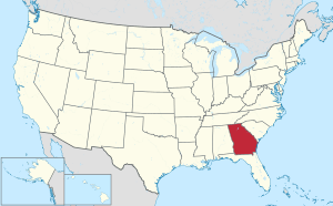 Georgia's location within the U.S. | |
| Coordinates: 32°53′N 84°18′W | |
| Country | |
| State | |
| Founded | December 15, 1824 |
| Named for | Stephen Upson |
| Seat | Thomaston |
| Largest city | Thomaston |
| Area | |
| • Total | 328 sq mi (850 km2) |
| • Land | 323 sq mi (840 km2) |
| • Water | 4.1 sq mi (11 km2) 1.3%% |
| Population | |
| • Estimate (2018) | 26,215 |
| • Density | 84/sq mi (32/km2) |
| Time zone | UTC−5 (Eastern) |
| • Summer (DST) | UTC−4 (EDT) |
| Congressional district | 3rd |
| Website | www |
Upson County comprises the Thomaston, GA Micropolitan Statistical Area, which is also included in the Atlanta-Athens-Clarke County-Sandy Springs, GA Combined Statistical Area.
History
Upson County was formed in 1824 and named after Stephen Upson, a state legislator.[3]
Geography
According to the U.S. Census Bureau, the county has a total area of 328 square miles (850 km2), of which 323 square miles (840 km2) is land and 4.1 square miles (11 km2) (1.3%) is water.[4] Upson County boasts the lowest average summer humidity in the state.
The vast majority of Upson County is located in the Upper Flint River sub-basin of the ACF River Basin (Apalachicola-Chattahoochee-Flint River Basin), with just a tiny northeastern corner of the county, north of Yatesville, located in the Upper Ocmulgee River sub-basin of the Altamaha River basin.[5]
Major highways


Adjacent counties
- Lamar County - north
- Pike County - north
- Monroe County - northeast
- Crawford County - southeast
- Taylor County - south
- Talbot County - southwest
- Meriwether County - northwest
Demographics
| Historical population | |||
|---|---|---|---|
| Census | Pop. | %± | |
| 1830 | 7,013 | — | |
| 1840 | 9,408 | 34.2% | |
| 1850 | 9,424 | 0.2% | |
| 1860 | 9,910 | 5.2% | |
| 1870 | 9,430 | −4.8% | |
| 1880 | 12,400 | 31.5% | |
| 1890 | 12,188 | −1.7% | |
| 1900 | 13,670 | 12.2% | |
| 1910 | 12,757 | −6.7% | |
| 1920 | 14,786 | 15.9% | |
| 1930 | 19,509 | 31.9% | |
| 1940 | 25,064 | 28.5% | |
| 1950 | 25,078 | 0.1% | |
| 1960 | 23,800 | −5.1% | |
| 1970 | 23,505 | −1.2% | |
| 1980 | 25,998 | 10.6% | |
| 1990 | 26,300 | 1.2% | |
| 2000 | 27,597 | 4.9% | |
| 2010 | 27,153 | −1.6% | |
| Est. 2018 | 26,215 | [6] | −3.5% |
| U.S. Decennial Census[7] 1790-1960[8] 1900-1990[9] 1990-2000[10] 2010-2013[1] | |||
2000 census
As of the census[11] of 2000, there were 27,597 people, 10,722 households, and 7,687 families living in the county. The population density was 85 people per square mile (33/km²). There were 11,616 housing units at an average density of 36 per square mile (14/km²). The racial makeup of the county was 70.58% White, 27.95% Black or African American, 0.25% Native American, 0.38% Asian, 0.02% Pacific Islander, 0.30% from other races, and 0.53% from two or more races. 1.18% of the population were Hispanic or Latino of any race.
There were 10,722 households out of which 31.70% had children under the age of 18 living with them, 50.70% were married couples living together, 16.90% had a female householder with no husband present, and 28.30% were non-families. 25.20% of all households were made up of individuals and 11.60% had someone living alone who was 65 years of age or older. The average household size was 2.53 and the average family size was 3.01.
In the county, the population was spread out with 25.50% under the age of 18, 8.30% from 18 to 24, 27.80% from 25 to 44, 23.50% from 45 to 64, and 14.90% who were 65 years of age or older. The median age was 37 years. For every 100 females there were 90.40 males. For every 100 females age 18 and over, there were 85.30 males.
The median income for a household in the county was $31,201, and the median income for a family was $37,418. Males had a median income of $30,484 versus $20,520 for females. The per capita income for the county was $17,053. About 11.20% of families and 14.70% of the population were below the poverty line, including 21.70% of those under age 18 and 11.70% of those age 65 or over.
2010 census
As of the 2010 United States Census, there were 27,153 people, 10,716 households, and 7,382 families living in the county.[12] The population density was 84.0 inhabitants per square mile (32.4/km2). There were 12,161 housing units at an average density of 37.6 per square mile (14.5/km2).[13] The racial makeup of the county was 68.8% white, 28.0% black or African American, 0.5% Asian, 0.3% American Indian, 1.2% from other races, and 1.2% from two or more races. Those of Hispanic or Latino origin made up 2.2% of the population.[12] In terms of ancestry, 21.4% were American, 13.1% were Irish, 9.3% were English, and 6.3% were German.[14]
Of the 10,716 households, 32.8% had children under the age of 18 living with them, 45.8% were married couples living together, 17.6% had a female householder with no husband present, 31.1% were non-families, and 27.4% of all households were made up of individuals. The average household size was 2.49 and the average family size was 3.00. The median age was 40.3 years.[12]
The median income for a household in the county was $34,509 and the median income for a family was $42,737. Males had a median income of $36,870 versus $27,075 for females. The per capita income for the county was $17,398. About 16.7% of families and 20.1% of the population were below the poverty line, including 25.9% of those under age 18 and 9.9% of those age 65 or over.[15]
Communities
City
Town
Census-designated places
Other unincorporated places
Politics
| Year | Republican | Democratic | Third parties |
|---|---|---|---|
| 2016 | 66.7% 7,292 | 31.8% 3,475 | 1.5% 167 |
| 2012 | 64.1% 7,230 | 35.1% 3,959 | 0.8% 90 |
| 2008 | 63.8% 7,291 | 35.5% 4,061 | 0.7% 82 |
| 2004 | 65.7% 6,634 | 33.9% 3,424 | 0.4% 36 |
| 2000 | 60.6% 5,019 | 38.1% 3,158 | 1.3% 105 |
| 1996 | 47.1% 3,783 | 43.5% 3,491 | 9.5% 761 |
| 1992 | 45.0% 4,053 | 41.6% 3,740 | 13.4% 1208 |
| 1988 | 63.1% 4,614 | 36.4% 2,666 | 0.5% 38 |
| 1984 | 62.0% 4,803 | 38.0% 2,943 | |
| 1980 | 36.5% 2,788 | 61.7% 4,713 | 1.8% 134 |
| 1976 | 40.7% 2,897 | 59.3% 4,219 | |
| 1972 | 84.5% 4,892 | 15.5% 896 | |
| 1968 | 22.7% 1,494 | 22.5% 1480 | 54.8% 3,599 |
| 1964 | 48.6% 3,103 | 51.3% 3,275 | 0.1% 6 |
| 1960 | 23.5% 1,001 | 76.5% 3,262 | |
| 1956 | 17.2% 712 | 82.8% 3,422 | |
| 1952 | 14.5% 648 | 85.6% 3,837 | |
| 1948 | 9.8% 293 | 81.3% 2,432 | 9.0% 268 |
| 1944 | 9.3% 243 | 90.7% 2,362 | |
| 1940 | 6.6% 159 | 93.4% 2,235 | |
| 1936 | 8.6% 138 | 91.4% 1,471 | 0.1% 1 |
| 1932 | 1.2% 20 | 98.6% 1,660 | 0.2% 4 |
| 1928 | 23.5% 221 | 76.5% 721 | |
| 1924 | 6.4% 37 | 83.3% 484 | 10.3% 60 |
| 1920 | 15.1% 170 | 84.9% 957 | |
| 1916 | 25.6% 259 | 72.6% 734 | 1.8% 18 |
| 1912 | 23.4% 138 | 75.4% 445 | 1.2% 7 |
Notable people
References
- "State & County QuickFacts". United States Census Bureau. Retrieved June 26, 2014.
- "Find a County". National Association of Counties. Retrieved June 7, 2011.
- Krakow, Kenneth K. (1975). Georgia Place-Names: Their History and Origins (PDF). Macon, GA: Winship Press. p. 238. ISBN 0-915430-00-2.
- "US Gazetteer files: 2010, 2000, and 1990". United States Census Bureau. February 12, 2011. Retrieved April 23, 2011.
- "Georgia Soil and Water Conservation Commission Interactive Mapping Experience". Georgia Soil and Water Conservation Commission. Retrieved November 20, 2015.
- "Population and Housing Unit Estimates". Retrieved July 31, 2019.
- "U.S. Decennial Census". United States Census Bureau. Retrieved June 26, 2014.
- "Historical Census Browser". University of Virginia Library. Retrieved June 26, 2014.
- "Population of Counties by Decennial Census: 1900 to 1990". United States Census Bureau. Retrieved June 26, 2014.
- "Census 2000 PHC-T-4. Ranking Tables for Counties: 1990 and 2000" (PDF). United States Census Bureau. Retrieved June 26, 2014.
- "U.S. Census website". United States Census Bureau. Retrieved January 31, 2008.
- "DP-1 Profile of General Population and Housing Characteristics: 2010 Demographic Profile Data". United States Census Bureau. Archived from the original on February 13, 2020. Retrieved December 30, 2015.
- "Population, Housing Units, Area, and Density: 2010 - County". United States Census Bureau. Archived from the original on February 13, 2020. Retrieved December 30, 2015.
- "DP02 SELECTED SOCIAL CHARACTERISTICS IN THE UNITED STATES – 2006-2010 American Community Survey 5-Year Estimates". United States Census Bureau. Archived from the original on February 13, 2020. Retrieved December 30, 2015.
- "DP03 SELECTED ECONOMIC CHARACTERISTICS – 2006-2010 American Community Survey 5-Year Estimates". United States Census Bureau. Archived from the original on February 13, 2020. Retrieved December 30, 2015.
- Leip, David. "Dave Leip's Atlas of U.S. Presidential Elections". uselectionatlas.org. Retrieved March 22, 2018.
Places adjacent to Upson County, Georgia | ||||||||||
|---|---|---|---|---|---|---|---|---|---|---|
| ||||||||||
Municipalities and communities of Upson County, Georgia, United States | ||
|---|---|---|
| City | Map of Georgia highlighting Upson County | |
| Town | ||
| CDPs | ||
| Unincorporated communities | ||
| Authority control |
|
|---|