Terrell County, Georgia
Terrell County is a county located in the southwestern portion of the U.S. state of Georgia. As of the 2010 census, the population was 9,315.[1] The county seat is Dawson.[2]
Terrell County | |
|---|---|
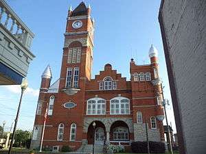 Terrell County Courthouse in Dawson | |
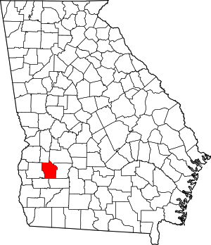 Location within the U.S. state of Georgia | |
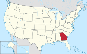 Georgia's location within the U.S. | |
| Coordinates: 31°47′N 84°26′W | |
| Country | |
| State | |
| Founded | February 16, 1856 |
| Named for | William Terrell |
| Seat | Dawson |
| Largest city | Dawson |
| Area | |
| • Total | 338 sq mi (880 km2) |
| • Land | 335 sq mi (870 km2) |
| • Water | 2.3 sq mi (6 km2) 0.7%% |
| Population | |
| • Estimate (2018) | 8,611 |
| • Density | 28/sq mi (11/km2) |
| Time zone | UTC−5 (Eastern) |
| • Summer (DST) | UTC−4 (EDT) |
| Congressional district | 2nd |
| Website | www |
Terrell County is included in the Albany, GA Metropolitan Statistical Area.
History
Formed from portions of Randolph and Lee counties on February 16, 1856, by an act of the Georgia General Assembly, Terrell County is named for Dr. William Terrell (1778–1855) of Sparta, Georgia, who served in the Georgia General Assembly and the United States House of Representatives.[3]
During the American Civil War, after Atlanta's capture by Union forces, a refugee settlement was established in Terrell County for civilians forced to flee the city. The Fosterville settlement, named after Georgia Quartermaster General Ira Roe Foster,[4] was according to author Mary Elizabeth Massey in her 2001 history, the "most ambitious refugee project approved by the Georgia General Assembly" [during that period].[5] On March 11, 1865, the Georgia General Assembly authorized General Foster to "continue to provide for maintenance of said exiles, or such of them as are unable by their labor to support themselves, or their families for the balance of the present year."[5]
During the civil rights era of the 1960s, the local white minority resisted change, sometimes violently; it subsequently became known as "Terrible Terrell County".[6] In September 1962, an African-American church was burned down after it was used for voter registration meetings.[7] (Note: Like other southern states, Georgia had disenfranchised most blacks at the turn of the century by rules raising barriers to voter registration; they were still excluded from the political system.) That month Prathia Hall delivered a speech at the site of the ruins, using the repeated phrase "I have a dream." Rev. Martin Luther King attended her speech; afterward, he also began to use that phrase, including in his noted speech in 1963 at the Lincoln Memorial in Washington, DC.[8]
Geography
According to the U.S. Census Bureau, the county has a total area of 338 square miles (880 km2), of which 335 square miles (870 km2) is land and 2.3 square miles (6.0 km2) (0.7%) is water.[9]
The western and southern two-thirds of Terrell County is located in the Ichawaynochaway Creek sub-basin of the ACF River Basin (Apalachicola-Chattahoochee-Flint River Basin). The county's northeastern third is located in the Kinchafoonee-Muckalee sub-basin of the same larger ACF River Basin.[10]
Major highways
Adjacent counties
- Webster County - north
- Sumter County - northeast
- Lee County - east
- Dougherty County - southeast
- Calhoun County - southwest
- Randolph County - west
Demographics
| Historical population | |||
|---|---|---|---|
| Census | Pop. | %± | |
| 1860 | 6,232 | — | |
| 1870 | 9,053 | 45.3% | |
| 1880 | 10,451 | 15.4% | |
| 1890 | 14,503 | 38.8% | |
| 1900 | 19,023 | 31.2% | |
| 1910 | 22,003 | 15.7% | |
| 1920 | 19,601 | −10.9% | |
| 1930 | 18,290 | −6.7% | |
| 1940 | 16,675 | −8.8% | |
| 1950 | 14,314 | −14.2% | |
| 1960 | 12,742 | −11.0% | |
| 1970 | 11,416 | −10.4% | |
| 1980 | 12,017 | 5.3% | |
| 1990 | 10,653 | −11.4% | |
| 2000 | 10,970 | 3.0% | |
| 2010 | 9,315 | −15.1% | |
| Est. 2018 | 8,611 | [11] | −7.6% |
| U.S. Decennial Census[12] 1790-1960[13] 1900-1990[14] 1990-2000[15] 2010-2013[1] | |||
2010 census
As of the 2010 United States Census, there were 9,315 people, 3,519 households, and 2,450 families living in the county.[16] The population density was 27.8 inhabitants per square mile (10.7/km2). There were 4,080 housing units at an average density of 12.2 per square mile (4.7/km2).[17] The racial makeup of the county was 61.2% black or African American, 36.6% white, 0.3% Asian, 0.2% American Indian, 0.8% from other races, and 0.9% from two or more races. Those of Hispanic or Latino origin made up 1.7% of the population.[16] In terms of ancestry, 8.7% were American, 5.7% were English, and 5.0% were Irish.[18]
Of the 3,519 households, 33.7% had children under the age of 18 living with them, 40.2% were married couples living together, 24.4% had a female householder with no husband present, 30.4% were non-families, and 26.7% of all households were made up of individuals. The average household size was 2.57 and the average family size was 3.11. The median age was 39.6 years.[16]
The median income for a household in the county was $27,909 and the median income for a family was $35,663. Males had a median income of $36,641 versus $25,461 for females. The per capita income for the county was $15,553. About 28.2% of families and 31.0% of the population were below the poverty line, including 44.4% of those under age 18 and 24.6% of those age 65 or over.[19]
2000 census
As of the census[20] of 2000, there were 10,970 people, 4,002 households, and 2,913 families living in the county. The population density was 33 people per square mile (13/km²). There were 4,460 housing units at an average density of 13 per square mile (5/km²). The racial makeup of the county was 60.69% Black or African American, 37.95% White, 0.20% Native American, 0.35% Asian, 0.03% Pacific Islander, 0.09% from other races, and 0.69% from two or more races. 1.24% of the population were Hispanic or Latino of any race.
There were 4,002 households out of which 33.30% had children under the age of 18 living with them, 44.10% were married couples living together, 24.00% had a female householder with no husband present, and 27.20% were non-families. 24.30% of all households were made up of individuals and 10.20% had someone living alone who was 65 years of age or older. The average household size was 2.69 and the average family size was 3.18.
In the county, the population was spread out with 28.40% under the age of 18, 9.50% from 18 to 24, 26.00% from 25 to 44, 23.20% from 45 to 64, and 13.00% who were 65 years of age or older. The median age was 35 years. For every 100 females, there were 88.30 males. For every 100 females age 18 and over, there were 82.60 males.
The median income for a household in the county was $26,969, and the median income for a family was $31,693. Males had a median income of $27,320 versus $19,895 for females. The per capita income for the county was $13,894. About 22.70% of families and 28.60% of the population were below the poverty line, including 40.50% of those under age 18 and 22.00% of those age 65 or over.
Notable people
- Benjamin J. Davis, Jr., Harvard Law School graduate and elected to New York City Council. Defended Angelo Herndon in Georgia against insurrection charges for organizing a union, resulting in a US Supreme Court case that ruled against Georgia's insurrection law as unconstitutional.[21]
- Walter Washington, activist and politician, elected as the first black mayor of Washington, D.C.[21] after Congress granted home rule to the city.
- Otis Redding, rhythm and blues singer; one of the first crossover artists appealing to both young blacks and whites in the post-World War II era.[21]
Politics
| Year | Republican | Democratic | Third parties |
|---|---|---|---|
| 2016 | 44.7% 1,874 | 54.1% 2,267 | 1.1% 48 |
| 2012 | 41.6% 1,834 | 57.7% 2,544 | 0.7% 29 |
| 2008 | 42.8% 1,890 | 56.6% 2,501 | 0.7% 30 |
| 2004 | 48.6% 1,859 | 51.0% 1,951 | 0.4% 17 |
| 2000 | 48.3% 1,504 | 50.9% 1,584 | 0.8% 25 |
| 1996 | 40.3% 1,111 | 54.8% 1,509 | 4.9% 135 |
| 1992 | 32.9% 1,143 | 55.9% 1,942 | 11.2% 389 |
| 1988 | 52.2% 1,517 | 47.6% 1,383 | 0.2% 5 |
| 1984 | 52.2% 1,744 | 47.8% 1,598 | |
| 1980 | 40.3% 1,378 | 58.8% 2,010 | 0.9% 32 |
| 1976 | 33.2% 1,168 | 66.8% 2,348 | |
| 1972 | 75.0% 2,057 | 25.0% 686 | |
| 1968 | 15.1% 545 | 35.3% 1276 | 49.7% 1,798 |
| 1964 | 77.2% 1,921 | 22.9% 569 | |
| 1960 | 17.4% 285 | 82.6% 1,352 | |
| 1956 | 13.5% 203 | 86.5% 1,300 | |
| 1952 | 21.2% 369 | 78.8% 1,375 | |
| 1948 | 25.5% 242 | 63.9% 608 | 10.6% 101 |
| 1944 | 2.9% 49 | 97.1% 1,639 | |
| 1940 | 0.0% 0 | 100.0% 1,040 | |
| 1936 | 4.4% 61 | 95.5% 1,336 | 0.1% 2 |
| 1932 | 2.3% 24 | 97.4% 1,000 | 0.3% 3 |
| 1928 | 11.5% 116 | 88.6% 897 | |
| 1924 | 6.5% 45 | 90.5% 630 | 3.0% 21 |
| 1920 | 8.8% 48 | 91.2% 500 | |
| 1916 | 1.8% 13 | 92.7% 677 | 5.5% 40 |
| 1912 | 2.2% 12 | 93.1% 500 | 4.7% 25 |
See also
References
- "State & County QuickFacts". United States Census Bureau. Retrieved June 26, 2014.
- "Find a County". National Association of Counties. Retrieved June 7, 2011.
- Krakow, Kenneth K. (1975). Georgia Place-Names: Their History and Origins (PDF). Macon, GA: Winship Press. p. 224. ISBN 0-915430-00-2.
- Lisa Tendrich Frank (2008). Women in the American Civil War. ABC-CLIO. p. 113. ISBN 978-1-85109-600-8.
- Mary Elizabeth Massey (2001). Refugee Life in the Confederacy. Louisiana State University Press. p. 246. ISBN 978-0-8071-2688-2.
- https://www.nytimes.com/1977/08/14/archives/still-terrible-terrell.html
- "Welcome to the Civil Rights Digital Library". crdl.usg.edu. Retrieved March 22, 2018.
- Holsaert, Faith et al. Hands on the Freedom Plow: Personal Accounts by Women in SNCC. University of Illinois Press, 2010, p. 180.
- "US Gazetteer files: 2010, 2000, and 1990". United States Census Bureau. February 12, 2011. Retrieved April 23, 2011.
- "Georgia Soil and Water Conservation Commission Interactive Mapping Experience". Georgia Soil and Water Conservation Commission. Retrieved November 24, 2015.
- "Population and Housing Unit Estimates". Retrieved July 31, 2019.
- "U.S. Decennial Census". United States Census Bureau. Retrieved June 26, 2014.
- "Historical Census Browser". University of Virginia Library. Retrieved June 26, 2014.
- "Population of Counties by Decennial Census: 1900 to 1990". United States Census Bureau. Retrieved June 26, 2014.
- "Census 2000 PHC-T-4. Ranking Tables for Counties: 1990 and 2000" (PDF). United States Census Bureau. Retrieved June 26, 2014.
- "DP-1 Profile of General Population and Housing Characteristics: 2010 Demographic Profile Data". United States Census Bureau. Archived from the original on February 13, 2020. Retrieved December 30, 2015.
- "Population, Housing Units, Area, and Density: 2010 - County". United States Census Bureau. Archived from the original on February 13, 2020. Retrieved December 30, 2015.
- "DP02 SELECTED SOCIAL CHARACTERISTICS IN THE UNITED STATES – 2006-2010 American Community Survey 5-Year Estimates". United States Census Bureau. Archived from the original on February 13, 2020. Retrieved December 30, 2015.
- "DP03 SELECTED ECONOMIC CHARACTERISTICS – 2006-2010 American Community Survey 5-Year Estimates". United States Census Bureau. Archived from the original on February 13, 2020. Retrieved December 30, 2015.
- "U.S. Census website". United States Census Bureau. Retrieved January 31, 2008.
- "An Overview of the Brazier Case", Georgia Civil Rights Cold Cases Project, Emory University, accessed 6 April 2016
- Leip, David. "Dave Leip's Atlas of U.S. Presidential Elections". uselectionatlas.org. Retrieved March 22, 2018.
External links
Places adjacent to Terrell County, Georgia | ||||||||||
|---|---|---|---|---|---|---|---|---|---|---|
| ||||||||||
Municipalities and communities of Terrell County, Georgia, United States | ||
|---|---|---|
| City | Map of Georgia highlighting Terrell County | |
| Towns | ||
| Unincorporated communities | ||
| Authority control |
|
|---|