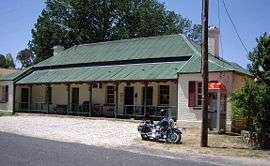
Tooma, New South Wales
Tooma is a village community in the eastern part of the Riverina and situated about 11 kilometres (6.8 mi) east of Welaregang and 34 kilometres (21 mi) south of Tumbarumba.
| Tooma New South Wales | |
|---|---|
 The Tooma Inn aka The Three Stags Inn | |
 Tooma | |
| Coordinates | 35°58′0″S 148°4′0″E |
| Population | 104 (2016 census)[1] |
| Postcode(s) | 2642 |
| Elevation | 331 m (1,086 ft) |
| Location |
|
| LGA(s) | Snowy Valleys Council |
| County | Selwyn |
| State electorate(s) | Albury |
| Federal Division(s) | Eden-Monaro |
Tooma is in the valley of the Tooma River, not far from its confluence with the Murray River.
Tooma Post Office opened on 1 January 1873.[2]
Gallery
 Looking down upon Tooma from the Welaregang Road.
 Tooma - Church of Our Lady of Perpetual Succor.
gollark: We run 1.12.
gollark: Well, I don't *know* of any, I guess I could add Robotic Parts/Cyberware at least.
gollark: No idea if it's updated.
gollark: I kind of remember that...
gollark: <@267332760048238593> https://minecraft.curseforge.com/projects/roboticparts
See also
References
- Australian Bureau of Statistics (27 June 2017). "Tooma (State Suburb)". 2016 Census QuickStats. Retrieved 29 June 2017.

- Premier Postal History, Post Office List, retrieved 11 June 2009
External links
![]()
This article is issued from Wikipedia. The text is licensed under Creative Commons - Attribution - Sharealike. Additional terms may apply for the media files.