Downside, New South Wales
Downside is a farming community in the central east part of the Riverina and situated about 15 kilometres north west from Wagga Wagga and 24 kilometres south east from Coolamon.[2]
| Downside New South Wales | |
|---|---|
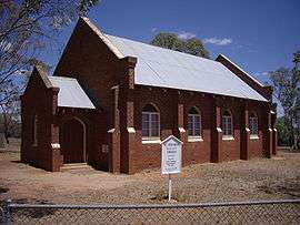 St Stephens - Downside | |
Downside | |
| Coordinates | 34°58′35″S 147°20′39″E |
| Population | 124 (2016 census)[1] |
| Postcode(s) | 2650 |
| Elevation | 279 m (915 ft) |
| Location |
|
| LGA(s) | City of Wagga Wagga |
| County | Clarendon |
| State electorate(s) | Wagga Wagga |
Downside Post Office opened on 15 August 1878 and closed in 1905.[3]

Downside Landcare Nursery
Notes and references
- Australian Bureau of Statistics (27 June 2017). "Downside (State Suburb)". 2016 Census QuickStats. Retrieved 27 June 2017.

- "Downside". Geographical Names Register (GNR) of NSW. Geographical Names Board of New South Wales. Retrieved 4 August 2013.
- Premier Postal History. "Post Office List". Retrieved 11 June 2009.
| Wikimedia Commons has media related to Downside, New South Wales. |
gollark: Last week I overhauled potatOS's peripheral handling for increased performance and fewer peripheral calls.
gollark: The performance considerations of the projects I work on are mostly dominated by I/O (peripheral calls and stuff) more than CPU use so it doesn't really matter but it would be nice to know.
gollark: I just do `for k, v in pairs(tbl)`, how is the performance of that?
gollark: Otherwise you could `ATTACH DATABASE ../1/database.db` or something and access other databases.
gollark: You need to block this sort of thing.
This article is issued from Wikipedia. The text is licensed under Creative Commons - Attribution - Sharealike. Additional terms may apply for the media files.