Welaregang, New South Wales
Welaregang is a rural community in the far south east part of the Riverina and situated about 11 kilometres south west from Tooma and 15 kilometres south east from Ournie. At the 2006 census, Welaregang had a population of 162.[1]
| Welaregang New South Wales | |
|---|---|
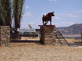
 Welaregang Station | |
 Welaregang | |
| Coordinates | 36°01′S 147°58′E |
| Population | 162 (2006 census)[1] |
| Postcode(s) | 2642 |
| Elevation | 310 m (1,017 ft) |
| Location | |
| County | Selwyn |
| State electorate(s) | Albury |
The community area is named after the parish of Welaregang, and the nearby Welaregang Station also takes the name. There are numerous other grazing properties nearby. Welaregang is situated on the Ournie to Tooma road, a dirt track, and only 3 kilometres (1.9 mi) from the Murray River, the border with Victoria.
Welaregang Post Office opened on 1 January 1861 and closed in 1873.[2]

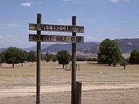
Welaregang Country Golf Club
The community boasts a Golf Club which is cut directly into the surrounding landscape.
Notes and references
- Australian Bureau of Statistics (25 October 2007). "Welaregang (State Suburb)". 2006 Census QuickStats. Retrieved 14 February 2010.
- Premier Postal History, Post Office List, retrieved 11 June 2009

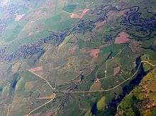
Aerial photo from north west
| Wikimedia Commons has media related to Welaregang, New South Wales. |
gollark: Well, yes, it should do that.
gollark: (note that you must log in to access this page. The password is "hahahaha this is a password")
gollark: https://minoteaur.osmarks.net/list_of_isomorphisms_to_bee
gollark: Have you *even* tried out the amazing/wondrous search?!
gollark: See, isn't this great?!
This article is issued from Wikipedia. The text is licensed under Creative Commons - Attribution - Sharealike. Additional terms may apply for the media files.