Binya, New South Wales
| Binya New South Wales | |
|---|---|
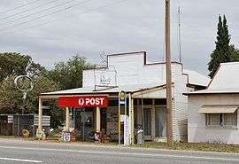 The General Store and Post Office at Binya | |
Binya | |
| Coordinates | 34°14′0″S 146°21′0″E |
| Population | 191 (2011 census)[1] |
| Postcode(s) | 2665 |
| Location | |
| LGA(s) | Narrandera Shire |
| County | Cooper |
| State electorate(s) | Cootamundra |
Demography
Like many rural localities in the area, the population has progressively declined over a number of years, evidenced as follows:
| Selected historical census data for Binya state suburb | |||||
|---|---|---|---|---|---|
| Census year | 2001 | 2006[3] | 2011[1] | ||
| Population | Estimated residents on Census night | unavailable | 238 | 191 | |
Facilities and services
The Temora–Roto railway line opened in 1916. Passenger services ceased in 1983 and the railway station closed in 1985. However the line remains open for goods trains.[4]
The Binya post office was opened on 19 June 1916.[5]
gollark: It says 4 million added lines.
gollark: Hold on, I'll load the latest data from their community metrics thing.
gollark: <@!330678593904443393> MediaWiki is about 20 times larger still?
gollark: My server is less responsive than usual even *after* I shut down the osmarks.net search engine rampantly consuming all resources.
gollark: That's an awful workaround which will probably break something for someone, when the solution is just a sane format with working escaping.
References
- Australian Bureau of Statistics (31 October 2012). "Binya (State Suburb)". 2011 Census QuickStats. Retrieved 5 January 2014.

- Travelmate Archived March 24, 2007, at the Wayback Machine
- Australian Bureau of Statistics (25 October 2007). "Binya (State Suburb)". 2006 Census QuickStats. Retrieved 15 June 2009.
- "Binya Station". NSWrail.net. Retrieved 10 November 2010.
- "Post office list". Premier postal history. Retrieved 11 June 2009.
| Preceding station | NSW Branch lines | Following station | ||
|---|---|---|---|---|
Yenda towards Roto | Temora- Roto Line | towards Temora |
This article is issued from Wikipedia. The text is licensed under Creative Commons - Attribution - Sharealike. Additional terms may apply for the media files.