Pretty Pine, New South Wales
Pretty Pine is a community in the central part of the Riverina and situated about 17 kilometres south of Wanganella and 18 kilometres north west of Deniliquin.
| Pretty Pine New South Wales | |
|---|---|
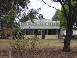 The Pretty Pine Hotel | |
Pretty Pine | |
| Coordinates | 35°25′S 144°52′E |
| Postcode(s) | 2710 |
| Location |
|
| LGA(s) | Edward River Council |
| County | Townsend |
| State electorate(s) | Murray |
| Federal Division(s) | Farrer |
Pretty Pine Post Office opened on 6 October 1890, was reduced to a Telephone office only in 1942 and closed in 1954.[1]
Notes and references
- Premier Postal History, Post Office List, retrieved 11 June 2009
| Wikimedia Commons has media related to Pretty Pine, New South Wales. |
gollark: You might want to actually have savings, as a worrying amount of people apparently don't.
gollark: You might live in somewhere with higher cost of living, as many software types do.
gollark: This is also probably wrong. There are perfectly good reasons to spend more than the median family on some category, especially if the categories are particularly granular.
gollark: Oh, and lots of things (particularly computing equipment) are usable for fun *and* work purposes.
gollark: As another example, I spend a nontrivial amount of money on removing small and cheap-to-fix inconveniences from my life (for example, finally getting a mouse as it's nicer than my laptop's trackpad in some ways, getting lots of spare USB cables so I don't have to deal with moving them around, buying pens in boxes of 50-100 so that I can just give them away). Obviously I don't *have* to do that, but I would be inconvenienced and somewhat less productive if I didn't.
This article is issued from Wikipedia. The text is licensed under Creative Commons - Attribution - Sharealike. Additional terms may apply for the media files.