Puja, Nepal
Pujan is a town and Village Development Committee in Pyuthan, a Middle Hills district of Rapti Zone, western Nepal.
Puja पुजाँ | |
|---|---|
Village Development Committee | |
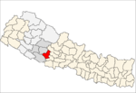
 Puja Location in Nepal | |
| Coordinates: 28.24°N 82.99°E | |
| Country | |
| Region | Mid-Western |
| Zone | Rapti Zone |
| District | Pyuthan District |
| VDC | Punjan |
| Population (2001 Census[1]) | |
| • Total | 3,871 |
| 793 households | |
| Time zone | UTC+5:45 (Nepal Time) |
Villages in this VDC
| Ward | Lat. | Lon | Elev. | ||
|---|---|---|---|---|---|
| Baglibang | बाग्लीबाङ | 3 | 28°15'N | 82°59'E | 2,010m |
| Baglidanda | बाग्लीडाँडा | 28°15'N | 82°58'E | 2,130 | |
| Chhewagaun | छेवगाउँ | 28°15'N | 82°59'E | 1,710 | |
| Dandakatti | डाँडाकट्टी | 28°14'N | 82°58'E | 2,010 | |
| Dhanmuda | धनबुडा | 28°13'N | 82°59'E | 1,650 | |
| Gaunphata | गाउँफाटा | 28°13'N | 83°00'E | 1,455 | |
| Gothanti | गोठाँटी | 28°13'N | 82°58'E | 1,049 | |
| Halhale | हलहले | 28°14'N | 82°59'E | 2,110 | |
| Jadagaun | जाडगाउँ | 28°15'N | 83°00'E | 1,710 | |
| Jemarkatta | जेमरकट्टा | 28°13'N | 83°00'E | 1,310 | |
| Kalle | कल्ले | 28°14'N | 83°01'E | 1,239 | |
| Kaphalbas | काफलबास | 1 | 28°13'N | 83°01'E | 1,425 |
| Khalachaur | खलचौर | 8 | 28°13'N | 82°58'E | 1,815 |
| Khasibang | खसीबाङ | 28°14'N | 82°59'E | 1,790 | |
| Kholabang | खोलाबाङ | 4 | 28°14'N | 82°59'E | 2,002 |
| Kolchaur | कोलचौर | 28°13'N | 83°01'E | 1,535 | |
| Laishara | लैस्वाँरा | 9 | 28°14'N | 82°58'E | 1,955 |
| Lamtinge | लामटिङ्गे | 28°13'N | 82°59'E | 1,610 | |
| Liwase | लिवासे | 1 | 28°14'N | 83°01'E | 1,190 |
| Mukhya Pokhara | मुख्य पखरा | 28°13'N | 83°00'E | 1,350 | |
| Okhreni | ओख्रेनी | 28°15'N | 83°00'E | 1,918 | |
| Pasabang | पासाबाङ | 28°14'N | 82°59'E | 1,790 | |
| Phalante | फलाँटे | 1 | 28°14'N | 83°01'E | 1,190 |
| Phapreta | फप्रेटा | 28°14'N | 82°58'E | 1,930 | |
| Phorsakharka | फोर्साखर्क | 1 | 28°14'N | 83°01'E | 1,405 |
| Puja | पुजाँ | 1 | 28°13'N | 83°00'E | 1,651 |
| Raghuwa | रघुवा | 28°14'N | 83°02'E | 1,470 | |
| Sasibang | सासीबाङ | 28°14'N | 83°00'E | 1,450 | |
| Thokresa | ठोक्रेसा | 1 | 28°13'N | 83°01'E | 1,225 |
gollark: <@332271551481118732> YOU COORDINATE EVENTS RIGHT
gollark: GIB TEST CASE AND ALSO ANSWERS
gollark: Oh, and can you submit improved versions?
gollark: Unless it's meant to wrap.
gollark: `ii` being infinite loop makes no sense.
References
- "Nepal Census 2001". Nepal's Village Development Committees. Digital Himalaya. Retrieved 21 September 2008.
- "Index of Geographical Names of Nepal, Volume IV: Mid Western Development Region, List of Settlements, Pyuthan" (PDF). Government of Nepal, National Geographic Information Infrastructure Program. Archived from the original (PDF) on 2011-07-24. Retrieved 2011-03-12.
External links
This article is issued from Wikipedia. The text is licensed under Creative Commons - Attribution - Sharealike. Additional terms may apply for the media files.