Cedar Springs, Michigan
Cedar Springs is a city in Kent County in the state of Michigan, United States, 20 miles north of Grand Rapids. The population was 3,509 at the 2010 census.
Cedar Springs, Michigan | |
|---|---|
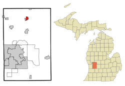 Location of Cedar Springs, Michigan | |
| Coordinates: 43°13′20″N 85°33′7″W | |
| Country | United States |
| State | Michigan |
| County | Kent |
| Government | |
| • Mayor | Gerald Hall[1] |
| Area | |
| • Total | 2.02 sq mi (5.23 km2) |
| • Land | 1.95 sq mi (5.06 km2) |
| • Water | 0.07 sq mi (0.17 km2) |
| Elevation | 856 ft (261 m) |
| Population | |
| • Total | 3,509 |
| • Estimate (2019)[4] | 3,711 |
| • Density | 1,900.15/sq mi (733.83/km2) |
| Time zone | UTC-5 (Eastern (EST)) |
| • Summer (DST) | UTC-4 (EDT) |
| ZIP code | 49319 |
| Area code(s) | 616 |
| FIPS code | 26-14200 |
| GNIS feature ID | 0622953[5] |
| Website | www |
History
Established as a lumber town in 1856, Cedar Springs boasted numerous lumber and shingle mills. The town was the northern terminus of the Grand Rapids and Indiana Railroad for two years and also was the crossing point for the east to west running Toledo, Saginaw and Muskegon Railway, which became the Grand Trunk Western Railroad, which was built through the town in 1888. The community was named for the fine springs bordered by a cedar grove.
Geography
According to the United States Census Bureau, the city has a total area of 2.10 square miles (5.44 km2), of which, 2.03 square miles (5.26 km2) of it is land and 0.07 square miles (0.18 km2) is water.[6]
Transportation
- Indian Trails provides daily intercity bus service between Grand Rapids, Michigan and Petoskey, Michigan.[7]
Demographics
| Historical population | |||
|---|---|---|---|
| Census | Pop. | %± | |
| 1880 | 1,141 | — | |
| 1890 | 1,035 | −9.3% | |
| 1900 | 950 | −8.2% | |
| 1910 | 947 | −0.3% | |
| 1920 | 1,020 | 7.7% | |
| 1930 | 1,104 | 8.2% | |
| 1940 | 1,101 | −0.3% | |
| 1950 | 1,378 | 25.2% | |
| 1960 | 1,768 | 28.3% | |
| 1970 | 1,807 | 2.2% | |
| 1980 | 2,615 | 44.7% | |
| 1990 | 2,600 | −0.6% | |
| 2000 | 3,112 | 19.7% | |
| 2010 | 3,509 | 12.8% | |
| Est. 2019 | 3,711 | [4] | 5.8% |
| U.S. Decennial Census[8] | |||
2010 census
As of the census[3] of 2010, there were 3,509 people, 1,215 households, and 887 families living in the city. The population density was 1,728.6 inhabitants per square mile (667.4/km2). There were 1,307 housing units at an average density of 643.8 per square mile (248.6/km2). The racial makeup of the city was 94.3% White, 0.8% African American, 0.6% Native American, 0.4% Asian, 0.9% from other races, and 3.0% from two or more races. Hispanic or Latino of any race were 4.2% of the population.
There were 1,215 households, of which 47.3% had children under the age of 18 living with them, 43.6% were married couples living together, 21.6% had a female householder with no husband present, 7.8% had a male householder with no wife present, and 27.0% were non-families. 22.2% of all households were made up of individuals, and 7% had someone living alone who was 65 years of age or older. The average household size was 2.81 and the average family size was 3.23.
The median age in the city was 29.6 years. 32.9% of residents were under the age of 18; 9.8% were between the ages of 18 and 24; 28.2% were from 25 to 44; 19.2% were from 45 to 64; and 9.9% were 65 years of age or older. The gender makeup of the city was 47.1% male and 52.9% female.
2000 census
As of the census of 2000, there were 3,112 people, 1,115 households, and 774 families living in the city. The population density was 1,701.9 per square mile (656.6/km2). There were 1,175 housing units at an average density of 642.6 per square mile (247.9/km2). The racial makeup of the city was 95.85% White, 0.29% African American, 0.74% Native American, 0.45% Asian, 1.19% from other races, and 1.48% from two or more races. Hispanic or Latino of any race were 3.82% of the population. The ancestries of the city are 24% German, 14.2% American, 13.7% Dutch, 9.8% Irish, 9.5% English, and 7.4% Polish.
There were 1,115 households, out of which 40.1% had children under the age of 18 living with them, 46.3% were married couples living together, 17.9% had a female householder with no husband present, and 30.5% were non-families. 24.2% of all households were made up of individuals, and 7.3% had someone living alone who was 65 years of age or older. The average household size was 2.71 and the average family size was 3.17.
In the city, the population was spread out, with 31.3% under the age of 18, 11.6% from 18 to 24, 31.0% from 25 to 44, 15.8% from 45 to 64, and 10.3% who were 65 years of age or older. The median age was 29.6 years (below state average). For every 100 females, there are 89.2 males. For every 100 females age 18 and over, there were 87.5 males.
The median income for a household in the city was $39,542, and the median income for a family was $42,250. Males had a median income of $37,708 versus $23,056 for females. The per capita income for the city was $16,040. About 12.4% of families and 13.8% of the population were below the poverty line, including 18.4% of those under age 18 and 7.5% of those age 65 or over.
Notable people
- Bert Carr, college football player with U of M; practiced medicine in Cedar Springs
- Mike Huckleberry, Michigan House of Representatives from the 70th district; born in Cedar Springs
- Charles Kelly, historian; Born in Cedar Springs
- Brad Slaight, actor, writer, comedian, Hollywood celebrity; born in Cedar Springs
- Carl Phillis, got his first DWI here
References
- "Mayor Gerald Hall". cityofcedarsprings.org. Retrieved January 4, 2020.
- "2019 U.S. Gazetteer Files". United States Census Bureau. Retrieved July 25, 2020.
- "U.S. Census website". United States Census Bureau. Retrieved 2012-11-25.
- "Population and Housing Unit Estimates". United States Census Bureau. May 24, 2020. Retrieved May 27, 2020.
- "US Board on Geographic Names". United States Geological Survey. 2007-10-25. Retrieved 2008-01-31.
- "US Gazetteer files 2010". United States Census Bureau. Archived from the original on 2012-01-25. Retrieved 2012-11-25.
- "GRAND RAPIDS-CADILLAC-TRAVERSE CITY-PETOSKEY" (PDF). Indian Trails. January 15, 2013. Retrieved 2013-03-09.
- "Census of Population and Housing". Census.gov. Retrieved June 4, 2015.
External links
Municipalities and communities of Kent County, Michigan, United States | ||
|---|---|---|
| Cities | 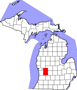 Map of Michigan highlighting Kent County | |
| Villages | ||
| Charter townships | ||
| General law townships | ||
| CDPs | ||
| Other unincorporated communities |
| |
| Footnotes | ‡This populated place also has portions in an adjacent county or counties | |