Byron Township, Michigan
Byron Township is a civil township of Kent County in the U.S. state of Michigan. As of the 2010 census, the population was 20,317,[4] up from 17,553 at the 2000 census.
Byron Township, Michigan | |
|---|---|
| Motto(s): "A Community on the Move"[1] | |
 Byron Township Location within Michigan and the United States  Byron Township Byron Township (the United States) | |
| Coordinates: 42°48′45″N 85°43′26″W | |
| Country | United States |
| State | Michigan |
| County | Kent |
| Area | |
| • Total | 36.2 sq mi (93.7 km2) |
| • Land | 36.1 sq mi (93.5 km2) |
| • Water | 0.08 sq mi (0.2 km2) |
| Elevation | 738 ft (225 m) |
| Population (2010) | |
| • Total | 20,317 |
| • Density | 563/sq mi (217.3/km2) |
| Time zone | UTC-5 (Eastern (EST)) |
| • Summer (DST) | UTC-4 (EDT) |
| ZIP codes | |
| Area code(s) | 616 |
| FIPS code | 26-081-12240[2] |
| GNIS feature ID | 1626016[3] |
| Website | www |
History
Communities
Byron Township was established in 1836.[5]
- Byron Center is an unincorporated community and census-designated place at the center of the township. The Byron Center ZIP code 49315 serves most of the township.[6]
- Carlisle or West Carlisle is an unincorporated, mostly historical locale in the township at 42°49′35″N 85°41′00″W.[7] Carlisle was a station on the Grand Rapids and Indiana Railroad. A post office named "West Carlisle" operated here from March 1884 until September 1910.[8]
- Corinth is an unincorporated community in the southeast part of the township on the boundary with Gaines Township.
- Cutlerville is an unincorporated community and census-designated place in the northeast of the township, straddling the boundary with Gaines Township.
- North Byron is an unincorporated community near the northern boundary of the township at 42°50′42″N 85°43′58″W.[9] It began as a settlement named "Scudderville" on Rush Creek with a station on the Lake Shore and Michigan Southern Railway. It was named for Henry W. Scudder, a local landowner. A post office named "North Byron" operated from October 1862 to December 1879 and from March 1894 to September 1903.[8]
- North Dorr is a tiny hamlet straddling the boundary between Byron Township and Dorr Township in Allegan County.[10]
- Ross is an unincorporated, mostly historical community in the southeast part of the township at 42°46′57″N 85°41′40″W.[11] Ross began as a depot on the Grand Rapids and Indiana Railroad and was first named "Ross Station". It was platted by William Thornton for William Ross in 1871. A post office was established in June 1871 with Daniel Ross as the first postmaster.[8]
- The city of Wyoming is to the north, and the Wyoming ZIP code 49509 historically served areas in the northern part of Byron Township.[12]
- The cities of Grand Rapids and Kentwood are to the northeast, and the Grand Rapids/Kentwood ZIP code 49548 also serves an area in the northeast part of Byron Township.[13][14]
- The city of Grandville is to the northwest, and the Grandville ZIP code 49418 serves areas in the northwest part of Byron Township.[15]
- The city of Wayland is to the south, and the Wayland ZIP code 49348 serves the southeast corner of the township.[16]
Geography
According to the United States Census Bureau, the township has a total area of 36.2 square miles (93.7 km2), of which 36.1 square miles (93.5 km2) are land and 0.1 square miles (0.2 km2), or 0.21%, are water.[4]
Demographics
As of the census[2] of 2000, there were 17,553 people, 6,454 households, and 4,711 families residing in the township. The population density was 480.1 per square mile (185.4/km2). There were 6,712 housing units at an average density of 183.6 per square mile (70.9/km2). The racial makeup of the township was 94.79% White, 1.21% African American, 0.32% Native American, 1.06% Asian, 0.02% Pacific Islander, 1.17% from other races, and 1.42% from two or more races. Hispanic or Latino of any race were 2.77% of the population.
There were 6,454 households, out of which 36.4% had children under the age of 18 living with them, 61.2% were married couples living together, 8.5% had a female householder with no husband present, and 27.0% were non-families. 21.3% of all households were made up of individuals, and 6.6% had someone living alone who was 65 years of age or older. The average household size was 2.71 and the average family size was 3.18.
In the township the population was spread out, with 29.0% under the age of 18, 9.0% from 18 to 24, 30.2% from 25 to 44, 20.9% from 45 to 64, and 10.9% who were 65 years of age or older. The median age was 34 years. For every 100 females, there were 100.0 males. For every 100 females age 18 and over, there were 96.7 males.
The median income for a household in the township was $49,672, and the median income for a family was $56,701. Males had a median income of $42,664 versus $26,449 for females. The per capita income for the township was $24,206. About 2.5% of families and 4.1% of the population were below the poverty line, including 4.4% of those under age 18 and 4.0% of those age 65 or over.
Economy
Michigan grocery distributor and retail operator Spartan Stores is headquartered in the township.[17][18]
Government
Township officials
- Supervisor Tom Hooker
- Clerk Peggy Sattler
- Treasurer Jacki Reed
- Trustee Bill DeBoer
- Trustee Tim Slot
- Trustee Drew Jones
References
- "Byron Township, Michigan". Byron Township, Michigan. Retrieved August 24, 2012.
- "U.S. Census website". United States Census Bureau. Retrieved 2008-01-31.
- U.S. Geological Survey Geographic Names Information System: Byron Township, Michigan
- "Geographic Identifiers: 2010 Census Summary File 1 (G001), Byron township, Kent County, Michigan". American FactFinder. U.S. Census Bureau. Archived from the original on February 13, 2020. Retrieved March 21, 2019.
- Walter Romig, Michigan Place Names, p. 91
- 49315 5-Digit ZCTA, 493 3-Digit ZCTA - Reference Map - American FactFinder, U.S. Census Bureau, 2000 census
- U.S. Geological Survey Geographic Names Information System: Carlisle, Michigan
- Romig, Walter (1986) [1973]. Michigan Place Names. Detroit, Michigan: Wayne State University Press. ISBN 0-8143-1838-X.
- U.S. Geological Survey Geographic Names Information System: North Byron, Michigan
- U.S. Geological Survey Geographic Names Information System: North Dorr, Michigan
- U.S. Geological Survey Geographic Names Information System: Ross, Michigan
- 49509 5-Digit ZCTA, 495 3-Digit ZCTA - Reference Map - American FactFinder, U.S. Census Bureau, 2000 census
- 49548 5-Digit ZCTA, 495 3-Digit ZCTA - Reference Map - American FactFinder, U.S. Census Bureau, 2000 census
- ZIP Code Lookup Archived September 3, 2007, at the Wayback Machine, United States Postal Service
- 49418 5-Digit ZCTA, 494 3-Digit ZCTA - Reference Map - American FactFinder, U.S. Census Bureau, 2000 census
- [tigerweb.geo.census.gov/tigerweb "TIGERweb: Byron Township, Kent County, Michigan; PUMAs, UGAs, and ZCTAs"] Check
|url=value (help). Geography Division, U.S. Census Bureau. Retrieved March 21, 2019. - "Contact Us." Spartan Stores. Retrieved on July 13, 2009.
- "Byron township, Kent County, Michigan." U.S. Census Bureau. Retrieved on July 13, 2009.
External links
Municipalities and communities of Kent County, Michigan, United States | ||
|---|---|---|
| Cities | 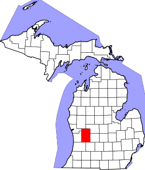 Map of Michigan highlighting Kent County | |
| Villages | ||
| Charter townships | ||
| General law townships | ||
| CDPs | ||
| Other unincorporated communities |
| |
| Footnotes | ‡This populated place also has portions in an adjacent county or counties | |