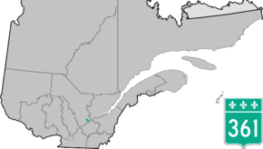
Quebec Route 361
Route 361 is a 20 km north-south regional road in Quebec, Canada, linking Batiscan and St-Narcisse, following the Batiscan river until Ste-Geneviève-de-Batiscan, the only village it goes through.
| ||||
|---|---|---|---|---|
 | ||||
| Route information | ||||
| Maintained by Transports Québec and the municipalities of Sainte-Geneviève-de-Batiscan and Saint-Narcisse[1] | ||||
| Length | 20.3 km[2] (12.6 mi) | |||
| Major junctions | ||||
| South end | ||||
| North end | ||||
| Highway system | ||||
| ||||

.jpg)
Route 361 at Ste-Geneviève-de-Batiscan
This road connects with Autoroute 40 at exit 229.
Municipalities along Route 361
- Batiscan
- Sainte-Genevieve-de-Batiscan
- Saint-Narcisse
Major intersections
| RCM or ET | Municipality | Km | Road | Notes |
|---|---|---|---|---|
| Les Chenaux | Batiscan | 0.0 | ||
| Sainte-Geneviève-de-Batiscan | 4.1 | |||
| 8.0 | Rue du Pont | To Sainte-Geneviève-de-Batiscan | ||
| Saint-Narcisse | 20.3 |
gollark: Oh, so you just have to *know* the platform behavior?
gollark: Oh no, imagine having checks?
gollark: Well, yes, but it's not required to by any specs, and can do literally whatever.
gollark: They will, however, not panic.
gollark: They are defined as working two's-complement-ly or something, there's an RFC on it.
See also
References
- The section between the villages of Sainte-Geneviève-de-Batiscan and Saint-Narcisse (km 8.0 to km 20.3) is a local road managed by the municipalities of Sainte-Geneviève-de-Batiscan and Saint-Narcisse
- Ministère des transports, "Distances routières", page 102, Les Publications du Québec, 2005
External links
- Provincial Route Map (Courtesy of the Quebec Ministry of Transportation) (in French)
- Route 361 on Google Maps
This article is issued from Wikipedia. The text is licensed under Creative Commons - Attribution - Sharealike. Additional terms may apply for the media files.