Manitoba Highway 1
Provincial Trunk Highway 1 (PTH 1) is Manitoba's section of the Trans-Canada Highway. It is a heavily used, 4-lane divided highway, with the exception of a short 18 km section in the southeastern corner of the province. It is the main link between southern Manitoba's largest cities, and also serves as the province's main transportation link to the neighbouring provinces of Saskatchewan (to the west) and Ontario (to the east). The highway is the only major east-west divided highway in Manitoba, and carries a large majority of east-west traffic within and through the province. It has full freeway status sections at Portage la Prairie and Winnipeg. The total distance of the Trans-Canada Highway in Manitoba is approximately 490 km (300 mi).
| ||||
|---|---|---|---|---|
| Trans-Canada Highway | ||||
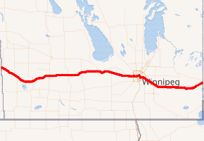
PTH 1 highlighted in red. | ||||
| Route information | ||||
| Maintained by Manitoba Infrastructure | ||||
| Length | 488.8 km[1] (303.7 mi) | |||
| Existed | 1942–present | |||
| Major junctions | ||||
| West end | Saskatchewan border near Kirkella continues west as | |||
| East end | Ontario border near West Hawk Lake continues east as | |||
| Location | ||||
| Districts | ||||
| Rural municipalities | ||||
| Major cities | ||||
| Towns | ||||
| Highway system | ||||
| Manitoba provincial highways Winnipeg City Routes
| ||||

PTH 1 is a very important part of the national highway system. It is the only road that links the province of Manitoba (and thus the entirety of Western Canada) with the province of Ontario, making it a major section of Canada's primary commercial and leisure route for all traffic travelling between Canada's largest cities, from Toronto and Montreal in the east to Calgary and Vancouver in the west.
Routing
The highway is routed from west to east across the province of Manitoba. It begins at the western provincial boundary with Saskatchewan, connecting with Saskatchewan's Highway 1 to become Manitoba Trans-Canada 1. The highway is designated as T-C 1 throughout Manitoba until it reaches the eastern provincial boundary with Ontario, where it continues as the main route to Kenora, Ontario and the rest of Eastern Canada as Highway 17.
The entire length of the Trans-Canada Highway in the province of Manitoba is a 4-lane divided highway, with the exception of the Winnipeg city route and an 18 kilometre section in eastern Manitoba between the town of Falcon Lake and the Manitoba-Ontario provincial boundary which is a two-lane highway.
PTH 1 has full expressway status on the routes around Winnipeg on the Perimeter Highway, and around Portage la Prairie. Plans do exist to bring the entire length of PTH 1 (except the Winnipeg city route) to full expressway status in the future (mentioned at the list of Manitoba expressways). Currently, exit numbers only exist at three interchanges,[2] and only small sections of PTH 1 and the Perimeter Highway have freeway status.
In the Winnipeg metro area, the Trans-Canada Highway has two official routes. The main route passes directly through the city of Winnipeg on city streets, entering the city from the west and continuing along Portage Avenue, Broadway, Main Street, Queen Elizabeth Way, St. Mary's Road, St. Anne's Road, and Fermor Avenue where it re-joins the Perimeter Highway (T-C 100) and continues east on TC 1. An alternate routing exits the main T-C 1 route on the western edge of Winnipeg onto the Perimeter Highway (T-C 100), which by-passes the city completely. The Perimeter Highway is a ring road which encircles Winnipeg and is frequently used by commuters and through traffic on the Trans Canada Highway wishing to avoid congested city streets.
History
The first Provincial Trunk Highways in Manitoba were numbered in 1926.[3] The original Highway 1 was one of nine highways fanning out from Winnipeg, but was different in that it fanned out from the west and the east. Highway 1 was routed via many already-existing highways and provincial secondary roads. (From west to east), these are:[4][5][6]
- Highway 1A into and out of Brandon
- Provincial Road 351 into and out of Carberry
- Highway 1A through Portage la Prairie
- Highway 26 from Portage la Prairie to Headingley
- Highway 9 from downtown Winnipeg to Lockport
- Highway 44 from Lockport to Whiteshell Provincial Park
In 1949, Highway 1 had been rerouted on new construction northeast of Griswold, with the part of old route from Highway 21 to Highway 28 (as well as Highway 28 itself) becoming part of Highway 21, and the section from Highway 21 eastward being removed from the system, but later becoming PR 455. By the early 1950s, Highway 1 had become an important east-west route in all of the western provinces. Most of the provincial highways that Highway 1 originally traversed on were re-numbered and designated as Highway 4 between 1958 and 1968, and the #1 was relocated to its present route. In 1962, the Trans-Canada Highway in Manitoba was fully completed, and Highway 1 across all of the western provinces was incorporated as part of the Trans-Canada Highway.
In 1955, most intra-city traffic in the Winnipeg area was diverted onto the (then) newly built Perimeter Highway. Later that year, the Perimeter Highway's southern (PTH 100) section was merged with the Trans-Canada Highway system, due to the amount of traffic using it to bypass the city. That section of the highway was highly used, and still is today.
Recent history
On October 6, 2006 the Trans-Canada Highway Portage la Prairie by-pass was closed due to a structural defect found in the bridge over the CN Rail Line. On October 31, 2007, a $19 million project to rebuild the bridge was completed, and the by-pass was fully re-opened to traffic.
On October 25, 2007, a major federal/provincial construction project twinning the highway in western Manitoba between the Saskatchewan-Manitoba provincial boundary and the town of Hargrave was completed, with 34 kilometres (21 mi) of newly divided highway lanes opened to traffic.
On April 9, 2008, the Government of Manitoba announced that construction of a new interchange would begin in the summer of 2008 at the intersection of Highway 16 (the Yellowhead Highway) and the Trans Canada Highway mainline route, located a short distance west of Portage la Prairie.[7] This project has been delayed and its current status is unknown.[8]
Speed limits
On February 27, 2008 the Manitoba Highway Traffic Board approved a request by the Government of Manitoba to raise the speed limit on the Trans Canada Highway in Manitoba to 110 km/h along the section between the Saskatchewan-Manitoba provincial boundary and Winnipeg.[9] The speed limit was officially raised on July 1, 2009, though it was only raised on one portion of the highway between the Saskatchewan provincial boundary to Virden.[10] On June 2, 2015, the speed limit between Virden and Headingley increased to 110 km/h, except at Brandon, Carberry, Portage la Prairie, and Elie, where speed is reduced due to major intersections at those locations.[11] The portion of the highway from Winnipeg to the Ontario provincial boundary remains at 100 km/h.
Saskatchewan provincial boundary to Headingley- 110 km/h (70 mph)
Virden- 80 km/h (50 mph)
Brandon- 80 km/h (50 mph)
Carberry- 100 km/h (60 mph)
Portage la Prairie (Freeway)- 100 km/h (60 mph)
Elie- 80 km/h (50 mph)
Headingley-70 km/h (45 mph)
Winnipeg bypass (Perimeter Hwy. PTH #100) - 100 km/h (60 mph)
Winnipeg city route
Portage Ave. - 60 km/h (35 mph) (50 km/h (30 mph) in downtown)
Broadway - 50 km/h (30 mph)
Queen Elizabeth Way. (S. Main Street) - 60 km/h (35 mph)
St. Mary's Rd. - 60 km/h (35 mph)
St. Anne's Rd. - 60 km/h (35 mph)
Fermor Ave. (To Autumnwood Dr./Lakewood Blvd.) - 70 km/h (45 mph)
Fermor Ave. (To Lagimodiere Blvd.) 80 km/h (50 mph)
Fermor Ave. (To Perimeter Hwy.) - 90 km/h (55 mph)
Eastern Manitoba- 100 km/h (60 mph)
All at-grade intersections with traffic lights -80 km/h (50 mph)
Major intersections
| Division | Location | km[1] | mi | Exit | Destinations | Notes | |
|---|---|---|---|---|---|---|---|
| Wallace – Woodworth | | 0.0 | 0.0 | Saskatchewan boundary | |||
| Kirkella | 5.5 | 3.4 | |||||
| Elkhorn | 17.1 | 10.6 | |||||
| 18.5 | 11.5 | Richhill Avenue E / Road 66 N | Former PR 441 | ||||
| Hargrave | 31.2 | 19.4 | Road 159 W | Former PR 252 south | |||
| | 34.8 | 21.6 | West end of PTH 83 concurrency | ||||
| | 41.6 | 25.8 | East end of PTH 83 concurrency | ||||
| Town of Virden | 44.5 | 27.7 | King Street E / Commonwealth Drive | ||||
| 46.6 | 29.0 | ||||||
| Sifton | | 62.8 | 39.0 | West end of PR 254 concurrency | |||
| Oak Lake | 68.0 | 42.3 | East end of PR 254 concurrency | ||||
| ↑ / ↓ | Griswold | 81.7 | 50.8 | ||||
| Whitehead | Alexander | 94.9 | 59.0 | West end of PR 250 concurrency | |||
| | 98.4 | 61.1 | East end of PR 250 concurrency | ||||
| Kemnay | 106.8 | 66.4 | Low bridge east of Kemnay; eastbound vehicles higher than 3.7m (12 ft) advised to stay on TCH | ||||
| | 110.8 | 68.8 | Crosses the Assiniboine River | ||||
| | 111.5 | 69.3 | Interchange | ||||
| Elton / Cornwallis | | 115.1 | 71.5 | ||||
| City of Brandon | 121.3 | 75.4 | West end of PTH 10 concurrency | ||||
| 123.0 | 76.4 | East end of PTH 10 concurrency | |||||
| Elton / Cornwallis | | 127.8 | 79.4 | ||||
| | 131.1 | 81.5 | |||||
| Elton | | 140.0 | 87.0 | ||||
| North Cypress – Langford | | 148.2 | 92.1 | ||||
| | 149.6 | 93.0 | |||||
| | 164.6 | 102.3 | Former PR 258 | ||||
| ↑ / ↓ | | 182.7 | 113.5 | ||||
| North Norfolk | Sidney | 184.3 | 114.5 | ||||
| Austin | 196.4 | 122.0 | |||||
| MacGregor | 210.0 | 130.5 | |||||
| Bagot | 219.8 | 136.6 | |||||
| Portage la Prairie | | 231.3 | 143.7 | Interchange proposed[12] | |||
| West end of | |||||||
| | 237.5 | 147.6 | Crosses the Portage Diversion (Assiniboine River Floodway) | ||||
| | 238.9 | 148.4 | — | Interchange | |||
| City of Portage la Prairie | 246.6 | 153.2 | — | Interchange | |||
| Portage la Prairie | | 250.7 | 155.8 | — | Interchange; no eastbound exit | ||
| | 251.9 | 156.5 | Former PTH 1 & 4 east | ||||
| | 260.0 | 161.6 | Crosses the Assiniboine River | ||||
| | 266.7 | 165.7 | |||||
| | 275.2 | 171.0 | Road 19 West | Former PR 331 west | |||
| Cartier | | 278.6 | 173.1 | Benard Road | Former PR 426 north | ||
| Elie | 285.4 | 177.3 | |||||
| | 294.1 | 182.7 | |||||
| | 301.5 | 187.3 | Former PR 241 | ||||
| ↑ / ↓ | | 303.1 | 188.3 | Crosses the Assiniboine River | |||
| St. François Xavier | | 303.9 | 188.8 | Former PTH 1 & 4 west | |||
| Headingley | 311.0 | 193.2 | Dodds Road | Former west end of PR 334 concurrency | |||
| 311.4 | 193.5 | Former east end of PR 334 concurrency. PR 334's northern terminus is now here. | |||||
| City of Winnipeg | 317.0 | 197.0 | 318 | Interchange; signed as exits 318A (east) and 318B (north); exit 42 on PTH 100 / PTH 101; west end of | |||
| 321.7 | 199.9 | ||||||
| 326.0 | 202.6 | Interchange | |||||
| 326.5 | 202.9 | Empress Street – Polo Park | Interchange; eastbound access to Route 90 north | ||||
| 329.0 | 204.4 | Broadway | PTH 1 branches east onto Broadway; east end of Route 85 concurrency | ||||
| East end of | |||||||
| 329.3 | 204.6 | One-way southbound | |||||
| 329.5 | 204.7 | One-way northbound | |||||
| 330.1 | 205.1 | Manitoba Legislative Building | |||||
| 330.9 | 205.6 | One-way southbound | |||||
| 331.0 | 205.7 | One-way northbound | |||||
| 331.3 | 205.9 | PTH 1 branches south onto Main Street; north end of Route 52 concurrency | |||||
| 331.7 | 206.1 | Main Street Bridge crosses the Assiniboine River | |||||
| 331.9 | 206.2 | River Avenue (via Stradbrook Avenue) | No northbound access | ||||
| 332.1 | 206.4 | Norwood Bridge crosses the Red River | |||||
| 332.3 | 206.5 | No northbound access | |||||
| 334.7 | 208.0 | PTH 1 branches southeast on St. Annes's Road; south end of Route 52 concurrency; north end of Route 150 concurrency | |||||
| 335.9 | 208.7 | PTH 1 branches east onto Fermor Avenue; south end of Route 150 concurrency; west end of Route 135 concurrency | |||||
| 337.2 | 209.5 | ||||||
| 337.9 | 210.0 | ||||||
| Springfield | | 342.5 | 212.8 | — | Plessis Road north | Interchange | |
| | 347.0 | 215.6 | 348 | Interchange; signed as exits 348A (west) and 348B (north); east end of | |||
| | 347.6 | 216.0 | Crosses the Red River Floodway | ||||
| Deacon's Corner | 349.5 | 217.2 | |||||
| Taché | | 357.4 | 222.1 | West end of PR 206 concurrency | |||
| | 359.4 | 223.3 | East end of PR 206 concurrency | ||||
| | 363.3 | 225.7 | |||||
| | 367.3 | 228.2 | |||||
| Ste. Anne | | 374.2 | 232.5 | 375 | Interchange; signed as exits 375A (south) and 375B (north) | ||
| | 382.5 | 237.7 | |||||
| Richer | 389.0 | 241.7 | |||||
| Reynolds | | 415.5 | 258.2 | Spruce Siding | Former PR 506 east | ||
| | 429.0 | 266.6 | |||||
| | 431.1 | 267.9 | |||||
| Prawda | 437.2 | 271.7 | |||||
| | 451.0 | 280.2 | |||||
| No. 1 | | 468.3 | 291.0 | Enters Whiteshell Provincial Park | |||
| Falcon Lake | 473.6 | 294.3 | — | Interchange | |||
| | 484.7 | 301.2 | — | Interchange; former PTH 1 & 4 west | |||
| | 488.8 | 303.7 | Ontario boundary | ||||
1.000 mi = 1.609 km; 1.000 km = 0.621 mi
| |||||||
See also
| Wikimedia Commons has media related to Trans-Canada Highway in Manitoba. |
References
- Google (January 25, 2018). "PTH 1 in Manitoba" (Map). Google Maps. Google. Retrieved January 25, 2018.
- Exits 318, 348, & 375
- "A.C. Emmett and the Development of Manitoba's Highways". The Government of Manitoba. Retrieved 2008-02-03.
- "Official map of Western Canada, 1946". The H.M. Gousha Company. Archived from the original on 2007-09-27. Retrieved 2008-02-03.
- "Route map of central and west North America, 1938". R. V. Droz. Archived from the original on 2009-10-26. Retrieved 2008-02-03.
- "The Atlas of Canada -- Major Roads, 1955". The Atlas of Canada. Archived from the original on 2012-02-29. Retrieved 2008-02-03.
- "Province of Manitoba - News Releases - Budget 2008 Charts Steady Course: Selinger". gov.mb.ca. Archived from the original on 2016-03-03. Retrieved 2017-09-04.
- "Archived copy" (PDF). Archived from the original (PDF) on 2015-09-24. Retrieved 2016-07-27.CS1 maint: archived copy as title (link)
- "Manitoba to raise speed limit". Archived from the original on 2015-09-24. Retrieved 2008-05-15.
- "Province of Manitoba - News Releases - Speed Limit To Increase On Certain Sections Of Twinned Highway". gov.mb.ca. Archived from the original on 2016-03-03. Retrieved 2017-09-04.
- "TransCanada speed limit in Manitoba increases to 110 km/h on June 2". cbc.ca. 23 April 2015.
- Manitoba's Highway Renewal Plan 2011-2015 (PDF). Government of Manitoba (Report). pp. 12–13. Archived from the original (PDF) on 24 September 2015. Retrieved 27 July 2016.
External links
- Official Name and Location - Declaration of Provincial Trunk Highways Regulation - The Highways and Transportation Act - Provincial Government of Manitoba
- Official Highway Map - Published and maintained by the Department of Infrastructure - Provincial Government of Manitoba (see Legend and Maps#1,2 & 3)
- Google Maps Search - Provincial Trunk Highway 1
| Preceded by |
Trans-Canada Highway |
Succeeded by |
| Preceded by | ||
| Preceded by |
Succeeded by |
| Preceded by |
Yellowhead Highway |
Succeeded by |
| British Columbia | ||
|---|---|---|
| Alberta | ||
| Saskatchewan | ||
| Manitoba | ||
| Ontario | ||
| Quebec | ||
| New Brunswick | ||
| Prince Edward Island | ||
| Nova Scotia | ||
| Newfoundland | ||
| ||