Sainte-Anne-de-Bellevue, Quebec
Sainte-Anne-de-Bellevue (French pronunciation: [sɛ̃t an də bɛlvy]) is an on-island suburb located at the western tip of the Island of Montreal in southwestern Quebec, Canada. It is the second oldest community in Montreal's West Island, having been founded as a parish in 1703. The oldest, Dorval, was founded in 1667.
Sainte-Anne-de-Bellevue | |
|---|---|
City | |
| City of Sainte-Anne-de-Bellevue | |
City Hall | |
| Motto(s): Omnia per laborem et fidem (All through work and faith) | |
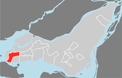
 Location on the Island of Montreal. (Outlined areas indicate demerged municipalities). | |
 Sainte-Anne-de-Bellevue Location in southern Quebec. | |
| Coordinates: 45°24′14″N 73°57′09″W[1] | |
| Country | |
| Province | |
| Region | Montreal |
| RCM | None |
| Founded | 1703 |
| Constituted | January 1, 2006 |
| Government | |
| • Mayor | Paola Hawa |
| • Federal riding | Lac-Saint-Louis |
| • Prov. riding | Jacques-Cartier |
| Area | |
| • Total | 11.20 km2 (4.32 sq mi) |
| • Land | 10.48 km2 (4.05 sq mi) |
| Population (2016) | |
| • Total | 4,958 |
| • Density | 473.0/km2 (1,225/sq mi) |
| • Pop 2011-2016 | |
| • Dwellings | 1,960 |
| Time zone | UTC−5 (EST) |
| • Summer (DST) | UTC−4 (EDT) |
| Postal code(s) | H9X |
| Area code(s) | 514 and 438 |
| Highways | |
| Website | www.ville.sainte-anne-de-bellevue.qc.ca |
Points of interest include the Sainte-Anne-de-Bellevue Canal (a National Historic Site of Canada), the Sainte-Anne Veterans' Hospital, the Morgan Arboretum, and the L'Anse-à-l'Orme Nature Park. Sainte-Anne-de-Bellevue is also home to John Abbott College and McGill University's Macdonald Campus, which includes the J. S. Marshall Radar Observatory and the Canadian Aviation Heritage Centre as well as about 2 square kilometres (0.77 sq mi) of farmland which separates the small town from neighbouring Baie-d'Urfé.
History

Sainte-Anne-de-Bellevue was established on a location once known and frequented by both the Algonquin and Iroquois peoples. Situated between two important lakes (Lac des Deux-Montagnes and Lac Saint Louis) and near the confluence of two important rivers (the Saint Lawrence River and the Ottawa River) both nations recognized its natural strategic advantages and had names for the place. The oral records show that it was named “Tiotenactokte” by the Algonquin, which means "place of the last encampments" and that the Iroquois called it “Skanawetsy” meaning "white waters, after the rapids".
In 1663, the Saint-Louis Mission was founded in the west end of Montreal Island at Pointe-Caron (site of the present-day Baie-d'Urfé yacht club), and was led by François-Saturnin Lascaris d'Urfé. At that time, the mission included the entire area form the tip of Montreal Island to Pointe-Claire, Île Perrot, Soulanges, Vaudreuil, and Île aux Tourtes.[5]
In 1672, King Louis XIV of France granded fiefdoms bordering on Lake of Two Mountains and Lake Saint-Louis to Louis de Berthé, Lord of Chailly, and to his brother Gabriel, Lord of La Joubardière. One of these adjacent fiefdoms was called Bellevue, due to its good views to the east and west. In 1677, the Parish of Saint-Louis-du-Bout-de-l'Île, sometimes also called Saint-Louis-du-Haut-de-l'Île, was founded. Jean de Lalonde was the first church warden. One September 30, 1687, Lalonde and four other parishioners were killed in a skirmish with the Iroquois.[6] In 1703, the parish was closed and its registers moved to Lachine because of the constant threat from the Iroquois.[1][5]
Around 1712, René-Charles de Breslay (1658–1735), local parish priest from 1703 to 1719, got caught in a fierce snowstorm. He fell from his horse, broke his leg on the ice, and lost the horse. Breslay was allegedly saved through the intervention by Saint Anne, after which he built a chapel dedicated to her at the westernmost point of Montreal Island next to Fort Senneville and Tourtes Island (Île aux Tourtes). Two years later, the parish was reestablished and took the name Sainte-Anne-du-Bout-de-l'Île.[1][5]
From the early 1800s the town became a place of literary pilgrimage after Thomas Moore the famous Irish composer wrote one of his most celebrated works Canadian Boat Song here.

In 1835, the local post office opened. In 1843, the Sainte-Anne Canal was completed, resulting in a large number of travellers and merchants passing through the village. Another impetus to its development came a few years later in 1854, when the Grand Trunk Railway was built through the area, followed by the Canadian Pacific Railway in 1887.
In 1845, the place was first incorporated as the Municipality of Bout-de-l'Isle. This was abolished two years later, but in 1855, it was reestablished as the Parish Municipality of Sainte-Anne-en-l'Isle-de-Montréal. In 1878, the main settlement was incorporated as a separate village municipality, and the parish municipality was renamed to Sainte-Anne-de-Bellevue that same year. The village municipality changed its status to town (ville) on January 12, 1895.[1]
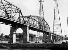
The early 20th century saw several developments in Sainte-Anne-de-Bellevue: the Macdonald College (affiliated to the McGill University) was established in 1907; the Federal Government built Ste. Anne's Veteran Hospital in 1917; the Galipeault Bridge was built in 1924 and doubled in 1964, linking Sainte-Anne-de-Bellevue with Île Perrot.[5] One of Canada's earliest Garden City experiments was undertaken in Sainte-Anne-de-Bellevue by John James Harpell, an industrialist, who around 1918 developed the 10 acres (4.0 ha) neighbourhood of Gardenvale.[7][8] The neighbourhood was granted its own post office in 1920.[9]
In 1911, the parish municipality lost part of its territory when Baie-d'Urfé became a separate municipality. In 1964, the town of Sainte-Anne-de-Bellevue annexed the parish municipality.
On January 1, 2002, as part of the 2002–2006 municipal reorganization of Montreal, Sainte-Anne-de-Bellevue was merged into the city of Montreal and became part of the borough of L'Île-Bizard–Sainte-Geneviève–Sainte-Anne-de-Bellevue. However, after a change of government and a 2004 referendum, it was re-constituted as an independent city on January 1, 2006.
Climate
| Climate data for Sainte-Anne-de-Bellevue (1971-2000) | |||||||||||||
|---|---|---|---|---|---|---|---|---|---|---|---|---|---|
| Month | Jan | Feb | Mar | Apr | May | Jun | Jul | Aug | Sep | Oct | Nov | Dec | Year |
| Record high °C (°F) | 11.0 (51.8) |
14.0 (57.2) |
23.5 (74.3) |
31.0 (87.8) |
32.2 (90.0) |
35.4 (95.7) |
34.5 (94.1) |
35.0 (95.0) |
32.7 (90.9) |
27.2 (81.0) |
23.0 (73.4) |
15.7 (60.3) |
35.4 (95.7) |
| Average high °C (°F) | −5.7 (21.7) |
−4.0 (24.8) |
1.9 (35.4) |
10.7 (51.3) |
18.6 (65.5) |
23.4 (74.1) |
26.2 (79.2) |
24.8 (76.6) |
19.5 (67.1) |
12.4 (54.3) |
5.1 (41.2) |
−2.7 (27.1) |
10.9 (51.5) |
| Daily mean °C (°F) | −10.4 (13.3) |
−8.6 (16.5) |
−2.6 (27.3) |
5.9 (42.6) |
13.2 (55.8) |
18.1 (64.6) |
21.0 (69.8) |
19.8 (67.6) |
14.6 (58.3) |
8.1 (46.6) |
1.7 (35.1) |
−7.0 (19.4) |
6.1 (43.1) |
| Average low °C (°F) | −15.0 (5.0) |
−13.2 (8.2) |
−7.0 (19.4) |
1.0 (33.8) |
7.7 (45.9) |
12.9 (55.2) |
15.7 (60.3) |
14.7 (58.5) |
9.7 (49.5) |
3.8 (38.8) |
−1.8 (28.8) |
−11.2 (11.8) |
1.4 (34.6) |
| Record low °C (°F) | −36.0 (−32.8) |
−35.0 (−31.0) |
−28.3 (−18.9) |
−13.3 (8.1) |
−3.9 (25.0) |
0 (32) |
5.5 (41.9) |
4.4 (39.9) |
−3.5 (25.7) |
−6.7 (19.9) |
−17.8 (0.0) |
−33.0 (−27.4) |
−36.0 (−32.8) |
| Average precipitation mm (inches) | 67.8 (2.67) |
58.4 (2.30) |
71.4 (2.81) |
69.6 (2.74) |
71.4 (2.81) |
88.6 (3.49) |
93.6 (3.69) |
104.2 (4.10) |
96.0 (3.78) |
77.2 (3.04) |
86.4 (3.40) |
78.2 (3.08) |
962.8 (37.91) |
| Average rainfall mm (inches) | 23.1 (0.91) |
20.0 (0.79) |
39.9 (1.57) |
59.7 (2.35) |
71.2 (2.80) |
88.6 (3.49) |
93.6 (3.69) |
104.2 (4.10) |
96.0 (3.78) |
76.3 (3.00) |
64.2 (2.53) |
31.0 (1.22) |
767.8 (30.23) |
| Average snowfall cm (inches) | 44.5 (17.5) |
37.9 (14.9) |
30.5 (12.0) |
9.5 (3.7) |
0.2 (0.1) |
0 (0) |
0 (0) |
0 (0) |
0 (0) |
0.9 (0.4) |
22.2 (8.7) |
45.4 (17.9) |
191.1 (75.2) |
| Average precipitation days (≥ 0.2 mm) | 13.9 | 11.1 | 11.7 | 11.5 | 13.9 | 13.1 | 12.7 | 12.9 | 13.1 | 13.2 | 13.7 | 14.8 | 155.6 |
| Average rainy days (≥ 0.2 mm) | 3.0 | 2.8 | 6.3 | 10.0 | 13.9 | 13.1 | 12.7 | 12.9 | 13.1 | 12.9 | 10.0 | 4.1 | 114.8 |
| Average snowy days (≥ 0.2 cm) | 11.2 | 8.9 | 6.1 | 1.9 | 0.05 | 0 | 0 | 0 | 0 | 0.43 | 4.6 | 11.3 | 44.48 |
| Mean monthly sunshine hours | 102.4 | 126.8 | 155.8 | 181.2 | 229.5 | 245.7 | 277.7 | 238.3 | 172.0 | 131.6 | 83.0 | 80.7 | 2,024.7 |
| Source: Environment Canada[10] | |||||||||||||
Government
The current mayor of Saint-Anne-de-Bellevue is Paola Hawa.
There are six city councilors:
- Dana Chevalier (District 1)
- Ryan Young (District 2)
- Francis Juneau (District 3)
- Tom Broad (District 4)
- Yvan Labelle (District 5)
- Denis Gignac (District 6)
List of mayors
The mayors of Sainte-Anne-de-Bellevue have been:[5]
- Jules Tremblay, 1878–1879
- Thomas Grenier, 1880–1884, 1885–1886
- Antoine St-Denis, 1881–1883
- D. Lebeau, 1887
- L. Michaud, 1888–1897
- M. C. Bezner, 1898–1899, 1901–1905, 1909–10, 1915–1916
- L.N.F. Cypihot, 1900, 1921–1922
- J.A. Aumais, 1906
- Guis. Daoust, 1906, 1917–1920
- Bruno Lalonde, 1907–1908, 1913–1914
- J.S. Vallée, 1911–1912
- L.J. Boileau, 1923–1931, 1933–1934
- A.R. Demers, 1932, 1935–1938
- E.E. Deslauriers, 1939–1951
- Philippe Godin, 1951–1965
- J.L. Paquin, 1965–1973
- Alphonse Trudeau, 1973–1978
- Marcel Marleau, 1978–1984
- René Martin, 1984–1994
- Bill Tierney, 1994–2001, 2005–2009
- Francis Deroo, 2009–2013
- Paula Hawa, 2013–present
Demographics
| Year | Pop. | ±% |
|---|---|---|
| 1966 | 5,334 | — |
| 1971 | 4,980 | −6.6% |
| 1976 | 3,738 | −24.9% |
| 1981 | 3,981 | +6.5% |
| 1986 | 4,140 | +4.0% |
| 1991 | 4,030 | −2.7% |
| 1996 | 4,700 | +16.6% |
| 2001 | 5,062 | +7.7% |
| 2006 | 5,197 | +2.7% |
| 2011 | 5,073 | −2.4% |
| 2016 | 4,958 | −2.3% |
| [11] | ||
| Language | Population (2006) | Percentage (2006) | Population (2011) | Percentage (2011) | Population (2016) | Percentage (2016) |
|---|---|---|---|---|---|---|
| English | 2,480 | 52.04% | 2,580 | 55.48% | 1,960 | 42.20% |
| French | 1,850 | 38.82% | 1,560 | 33.55% | 1,570 | 33.80% |
| Both English and French | 80 | 1.68% | 105 | 2.26% | 130 | 2.80% |
| Other languages | 355 | 7.45% | 290 | 6.24% | 885 | 19.05% |
In the city the population was spread out, with 18.5% under the age of 15, 10.4% from 15 to 24, 33.0% from 25 to 44, 17.5% from 45 to 64, and 20.8% who were 65 years of age or older. The median age was 38 years. For every 100 females there were 112.8 males. For every 100 females age 15 and over, there were 116.8 males.
There were 1,930 households, out of which 29.8% had children living with them, 40.7% were married couples living together, 7.3% had a female lone-parent as a householder, and 30.6% of all households were made up of individuals. The average married-couple family size was 3.1.
Christians made up 79.4% of the population, or 61.7% Catholic, 16.5% Protestant, 0.9% Eastern Orthodox, and 0.3% other Christian. Other religions in the city include 3.3% Muslim, 1.3% Jewish, 1.3% Eastern religions, and 0.3% other religions. 14.1% of the population claimed to have no religious affiliation.
The median income for a household in the city was $44,092, and the median income for a family was $65,637. Males had an average income of $41,619 versus $28,026 for females. About 5.7% of the labour force was unemployed. The largest occupation categories were 21.2% employed in business, finance, and administration occupations, 18.4% sales and service occupations, and 14.8% in social science, education, government service and religion occupations.
Note: Percentages may not add up to 100 percent due to rounding of data samples
Transportation
Sainte-Anne-de-Bellevue is traversed by Autoroute 40 (the Trans-Canada Highway) and Autoroute 20, which crosses the Ottawa River over the Galipeault Bridge linking it to Île Perrot.
For public transit, the town is served by the Sainte-Anne-de-Bellevue commuter train station on the Vaudreuil-Hudson Line. It also covered by the bus network of the Société de transport de Montréal.
It is planned that Sainte-Anne-de-Bellevue would be the westernmost terminus for the newly planned Réseau express métropolitain rapid transit system on the island of Montreal.
Education
The Commission scolaire Marguerite-Bourgeoys operates Francophone public schools.[14] It operates the École primaire du Bout-de-l'Isle.
The Lester B. Pearson School Board (LBPSB) operates Anglophone public schools in the area. It operates Macdonald High School.
The zoned elementary school is Dorset Elementary School in Baie-D'Urfé[15]
See also
- List of former boroughs
- Montreal Merger
- Municipal reorganization in Quebec
- Morgan Arboretum
- Ecomuseum Zoo
References
- "Sainte-Anne-de-Bellevue (Ville)" (in French). Commission de toponymie du Québec. Retrieved May 31, 2010.
- "Page inexistante : Erreur 404 - MAMOT - Ministère des Affaires municipales et de l'Occupation du territoire". Mamrot.gouv.qc.ca. Archived from the original on May 1, 2017. Retrieved December 21, 2017.
- "History of Federal Ridings since 1867". 2.parl.gc.ca. Retrieved December 21, 2017.
- Canada, Government of Canada, Statistics. "Statistics Canada: 2011 Census Profile". 12.statcan.gc.ca. Retrieved December 21, 2017.
- "History", City of Sainte-Anne-de-Bellevue
- Chronological History of the Life of Jean De Lalonde, Erik Lalonde, 2003
- Kristian Gravenor, JJ Harpell underrated local legend, Accessed November 11, 2015
- Canadian Cooperative Hall of Fame, John James Harpell citation, Accessed November 11, 2015
- Library and Archives Canada: Post Offices and Postmasters, Gardenvale, Accessed November 11, 2015
- Canada, Environment and Climate Change. "Canadian Climate Normals 1971-2000 Station Data - Climate - Environment and Climate Change Canada". climate.weather.gc.ca. Retrieved December 21, 2017.
- "Profil sociodéographique: Ville de Sainte-Anne-de-Bellevue" (PDF) (in French). Ville de Montréal. 2013. Retrieved October 28, 2013.
- Canada, Government of Canada, Statistics. "Statistics Canada: 2006 Community Profiles". 12.statcan.gc.ca. Retrieved December 21, 2017.
- Canada, Government of Canada, Statistics. "Statistics Canada: 2011 Census Profile". 12.statcan.gc.ca. Retrieved December 21, 2017.
- "ÉCOLES ET CENTRES." Commission Scolaire Marguerite-Bourgeoys. Retrieved on December 7, 2014.
- "School Board Map." Lester B. Pearson School Board. Retrieved on September 28, 2017.
External links
| Wikimedia Commons has media related to Sainte-Anne-de-Bellevue. |
- Official website
- Ecomuseum
- Parks Canada – Sante-Anne-de-Bellevue locks
- Ste-Anne-de-Bellevue Rugby Club
- Nursing Services