Quebec Route 362
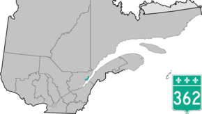
Route 362 is a scenic 50 km two-lane highway which follows the Saint Lawrence River in the Charlevoix region in Quebec, Canada. It starts at the junction of Route 138 in Baie-Saint-Paul and ends again at the junction of Route 138 in La Malbaie. Route 138 provides a more direct link between those two towns, and Route 362 is mainly a touristic route with vistas of the Saint Lawrence River, and the road goes up and down some serious hills next to the river.
| ||||
|---|---|---|---|---|
 | ||||
| Route information | ||||
| Maintained by Transports Québec | ||||
| Length | 50.0 km[1] (31.1 mi) | |||
| Major junctions | ||||
| West end | ||||
| East end | ||||
| Location | ||||
| Major cities | Baie-Saint-Paul, Les Éboulements, La Malbaie | |||
| Highway system | ||||
| ||||

Towns along Route 362
- Baie-Saint-Paul
- Saint-Joseph-de-la-Rive
- Les Éboulements
- Saint-Irenee
- La Malbaie
gollark: Inevitably, yes.
gollark: * yes
gollark: Oh, yes, I'm PRETTY sure that's MAYBE fine, I fixed RPNv2 and you could only XSS yourself anyway.
gollark: Hmm, apparently my invite to the thing expired, <@!332271551481118732> fix.
gollark: Github is probably pretty XSS-proof.
See also
References
- Ministère des transports, "Distances routières", page (?), Les Publications du Québec, 2005
External links
- Provincial Route Map (Courtesy of the Quebec Ministry of Transportation) (in French)
- Route 362 on Google Maps
This article is issued from Wikipedia. The text is licensed under Creative Commons - Attribution - Sharealike. Additional terms may apply for the media files.