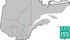
Quebec Route 155
Route 155 is a north/south highway on the north shore of the Saint Lawrence River in Quebec, Canada. Its northern terminus is in Chambord at the junction of Route 169, and the southern terminus is the Piles Bridge in Shawinigan. Previously the highway continued to Autoroute 20 but that section was decommissioned in 2006 when Autoroute 55 was completed.[2]
| ||||
|---|---|---|---|---|
 | ||||
| Route information | ||||
| Maintained by Transports Québec | ||||
| Length | 248.3 km[1] (154.3 mi) | |||
| Major junctions | ||||
| South end | ||||
| North end | ||||
| Location | ||||
| Counties | Shawinigan / Mékinac / La Tuque / Le Domaine-du-Roy | |||
| Major cities | Shawinigan, La Tuque | |||
| Highway system | ||||
| ||||

Most of the length of the highway runs in the Mauricie region very close to the Saint-Maurice River on the opposite side of which is the La Mauricie National Park (Parks Canada). Several small bridges and roads connect the park to Highway 155. It is also the main ground transportation route between the Mauricie and Centre-du-Québec regions and the Saguenay–Lac-Saint-Jean.
Municipalities along Route 155
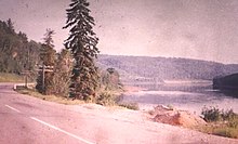
Quebec Route 155 near La Tuque in 1963
Major Intersections
| RCM or ET | Municipality | Km | Junction | Notes |
|---|---|---|---|---|
Southern terminus of Route 155 | ||||
| Shawinigan | 0.0 | Saint-Maurice River | ||
| 1.1 | 90e Avenue | EAST: to | ||
| Mékinac | Saint-Roch-de-Mékinac | 24.0 | 159 SOUTH: to Saint-Tite | |
| 29.6 | Chemin de Saint-Joseph | EAST: to Trois-Rives | ||
| La Tuque | 115.4 | Downtown La Tuque | ||
| 117.2 | Rue Bostonnais | NORTH: to La Croche | ||
| 149.1 | Chemin du Lac-Édouard | EAST: to Lac-Édouard | ||
| Le Domaine-du-Roy | Chambord | 248.3 | 169 SOUTH: to Métabetchouan–Lac-à-la-Croix 169 NORTH: to Roberval | |
Northern terminus of Route 155 | ||||
gollark: mèmètíç
gollark: Ah. What strange memés.
gollark: But what is "owo" and "uwu"?
gollark: That's unhelpful.
gollark: ???
See also
References
- Ministère des transports, "Distances routières", page 71, Les Publications du Québec, 2005 (Distance between Chambord and Pont des Piles)
- Ministère des Transport: "Carte routière officiel, Le Québec", Les Publications du Québec, 2007
External links
- Interactive Provincial Route Map (Transports Québec) (in French)
- Route 155 on Google Maps
This article is issued from Wikipedia. The text is licensed under Creative Commons - Attribution - Sharealike. Additional terms may apply for the media files.