Quebec Route 368
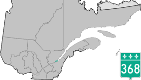
Route 368 is a 72 km two-lane east/west highway in Quebec, Canada, which is located on Île d'Orléans and includes the Pont de l'Île which connects the island to the mainland. It starts at the junction of Autoroute 40 at exit 325 in Beauport, now part of Quebec City, crosses the bridge and it follows around the island's perimeter, passing through all 6 villages on the island.
| ||||
|---|---|---|---|---|
 | ||||
| Route information | ||||
| Maintained by Transports Québec | ||||
| Length | 72.0 km[1] (44.7 mi) | |||
| Major junctions | ||||
| West end | ||||
| East end | ||||
| Location | ||||
| Major cities | Quebec City | |||
| Highway system | ||||
| ||||


Route 368 in the centre of Saint-Laurent
On Orleans Island, the route is also known as Chemin Royal (Royal Road) which was completed in 1744.[2]
Towns located along Route 368
- Beauport, Quebec City
- Saint-Pierre-de-l'Île-d'Orléans
- Sainte-Famille
- Saint-Francois
- Saint-Jean
- Saint-Laurent-de-l'Ile-d'Orleans
- Sainte-Pétronille
gollark: I have no idea why but I never encountered any backlight issues, using the normal Intel iGPU backlight stuff works perfectly.
gollark: I just bought a used laptop, which is both cheaper and does not technically support Nvidia.
gollark: Yes, it's Nvidia's fault, but that doesn't make it work better.
gollark: Sure, but Nouveau doesn't have working power management or video decode acceleration and such.
gollark: I use PRIME, as documented on the Arch wiki somewhere; you can instruct the dedicated GPU to render certain programs and send them to the integrated GPU.
See also
References
- Ministère des transports, "Distances routières", page (?), Les Publications du Québec, 2005
- "Discover the Island". Courtepointe et Cafe Association of B&Bs on Orleans Island. Retrieved 2009-10-29.
External links
- Provincial Route Map (Courtesy of the Quebec Ministry of Transportation) (in French)
- Route 368 on Google Maps
This article is issued from Wikipedia. The text is licensed under Creative Commons - Attribution - Sharealike. Additional terms may apply for the media files.