Quebec Route 363
Route 363 (highest elevation: 575 ft or 175.3 m) is a 53 kilometres (33 mi) south-north route in Quebec, Canada, going from Route 138 in Deschambault-Grondines along the St-Lawrence river to Lac-aux-Sables.
| ||||
|---|---|---|---|---|
 | ||||
| Route information | ||||
| Maintained by Ministère des transports du Québec | ||||
| Length | 51.2 km[1] (31.8 mi) | |||
| Major junctions | ||||
| North end | ||||
| South end | ||||
| Location | ||||
| Major cities | Deschambault-Grondines | |||
| Highway system | ||||
| ||||

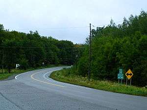
It goes through St-Marc-des-Carrières where it is called Boulevard Bona-Dussault. After St-Marc, it enters a forest and then runs parallel to a railroad track.
It is then concurrent for about 3 km in St-Casimir with Route 354 along the Rivière Ste-Anne, where it is rue (street) Notre-Dame. Once it crosses the river, heading north, it is called Boulevard de la Montagne.
It also goes through St-Ubalde after having climbed the Laurentian Mountains. In the village of St-Ubalde, it has the name of Boulevard Chabot, but out of town, it takes the name of Rang St-Achille.
It ends at the junction of Route 153 in Lac Aux Sables.
There is an overpass at the Autoroute 40, where there is exit 254. This exit is a major truck stop with now 2 restaurants and gas stations on each side of the freeway. There is now a brand new Subway restaurant just built on the south side of the 40, along with a new and modern Esso gas station.
Towns along Route 363
- Deschambault-Grondines
- Saint-Marc-des-Carrieres
- Saint-Casimir
- Saint-Ubalde
- Montauban-les-Mines
- Lac-aux-Sables
Major Intersection
| RCM or ET | Municipality | Km | Road | Notes |
|---|---|---|---|---|
| Portneuf | Deschambault-Grondines | 0.0 | Southern terminus of Route 363 | |
| 2.0 | Exit 254 (A-40) | |||
| Saint-Marc-des-Carrières | 8.2 | Rue du Collège (To Saint-Gilbert) | ||
| 9.0 | Rue Bourque (To Saint-Alban) | |||
| Saint-Casimir | 13.1 | Southern terminus of Route 354/Route 363 overlap | ||
| 15.1 | Route des Grondines (To Grondines) | |||
| 16.8 | Northern terminus of Route 354/Route 363 overlap | |||
| 21.6 | 3e Rang (To Saint-Thuribe) | |||
| Mékinac | Notre-Dame-de-Montauban | 43.7 | Northern terminus of Route 367 | |
| Lac-aux-Sables | 51.2 | Northern terminus of Route 153 Northern terminus of Route 363 |
See also
References
- Distances routières, page 102, Les Publications du Québec, 2005
External links
- Provincial Route Map (Courtesy of the Quebec Ministry of Transportation) (in French)
- Route 363 on Google Maps