Kolosh Glacier
Kolosh Glacier (Bulgarian: ледник Колош, romanized: lednik Kolosh, IPA: [ˈlɛdnik ˈkɔɫoʃ]) is the 6.7 km long and 3.6 km wide glacier on Magnier Peninsula, Graham Coast on the west side of Antarctic Peninsula, situated south of Nesla Glacier. It drains the west slopes of Lisiya Ridge north of Mount Bigo, and flows northwestwards into Bigo Bay next south of the terminus of Nesla Glacier.
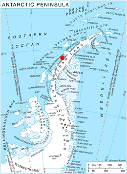
Location of Magnier Peninsula on Graham Coast, Antarctic Peninsula.
The glacier is named after Kolosh Peak in Konyavska Mountain, Western Bulgaria.
Location
Kolosh Glacier is centred at 65°44′50″S 64°18′30″W. British mapping in 1971.
Maps
- British Antarctic Territory. Scale 1:200000 topographic map. DOS 610 Series, Sheet W 65 64. Directorate of Overseas Surveys, Tolworth, UK, 1971.
- Antarctic Digital Database (ADD). Scale 1:250000 topographic map of Antarctica. Scientific Committee on Antarctic Research (SCAR), 1993–2016.
gollark: All tools above some minimum standard technically *work*. Lots are *very bad*.
gollark: But they have varying expressiveness, to the point that unless you're one of a few weird people you have to implement an interpreter to get any work done (e.g. BF).
gollark: Sure, most common languages are Turing-complete and can *technically* do any task you want (ignoring IO).
gollark: I don't like the "a good craftsman does not blame tools" thing applied to programming.
gollark: I heard about someone using *Python 2* for workoidal purposes.
References
- Bulgarian Antarctic Gazetteer. Antarctic Place-names Commission. (details in Bulgarian, basic data in English)
- SCAR Composite Gazetteer of Antarctica.
External links
- Kolosh Glacier. Copernix satellite image
This article includes information from the Antarctic Place-names Commission of Bulgaria which is used with permission.
This article is issued from Wikipedia. The text is licensed under Creative Commons - Attribution - Sharealike. Additional terms may apply for the media files.