Tain railway station
Tain railway station is a railway station serving the burgh of Tain in the Highland council area of Scotland. The station is on the Far North Line and is currently (2012) unmanned.
| Tain | |
|---|---|
| Scottish Gaelic: Baile Dhubhthaich[1] | |
 | |
| Location | |
| Place | Tain |
| Local authority | Highland |
| Coordinates | 57.8144°N 4.0519°W |
| Grid reference | NH781823 |
| Operations | |
| Station code | TAI |
| Managed by | Abellio ScotRail |
| Number of platforms | 2 |
| Live arrivals/departures, station information and onward connections from National Rail Enquiries | |
| Annual rail passenger usage* | |
| 2014/15 | |
| 2015/16 | |
| 2016/17 | |
| 2017/18 | |
| 2018/19 | |
| History | |
| Original company | Inverness and Ross-shire Railway |
| Pre-grouping | Highland Railway |
| Post-grouping | LMSR |
| 1 June 1864[2] | Opened |
| Listed status | |
| Listing grade | Category B |
| Entry number | LB41910[3] |
| Added to list | 6 October 1978 |
| National Rail – UK railway stations | |
| * Annual estimated passenger usage based on sales of tickets in stated financial year(s) which end or originate at Tain from Office of Rail and Road statistics. Methodology may vary year on year. | |
In its heyday the station had a staff of approximately thirty people. The station was opened on 1 June 1864 by the Highland Railway.[2] Murdoch Paterson was the engineer involved in the construction of the station (1863–1864).
Facilities
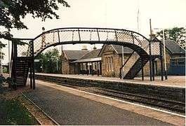
The station is 44 miles 23 chains (71.3 km) from Inverness, and has a passing loop 24 chains (480 m) long, flanked by two platforms. Platform 1 on the up (southbound) line can accommodate trains having seven coaches, whereas platform 2 on the down (northbound) line can hold eight.[4]
Engine shed
1st shed
- Former Invergordon Shed (Timber Built) was re-erected and opened in June 1864 (located approximately NH7068.01/1A) - facilities included turntable. Burned down 20 April 1877.[5]
2nd shed
- Slated Gable Style (Stone Built) Opened in 1877 (Sub-Shed to Helmsdale)- no facilities at the shed but a water column and turntable located at station. Dept closed 18 June 1962 (Demolished).[5]
Turntable
- Demolished (Pit filled in but pit wall tops still visible)
Signal Box South
- Demolished
Signal Box North
- Demolished
Water tank
- Stone Built sub-structure supporting cast iron tank. Demolished
Services
There are four through trains northbound to Wick & Thurso in the May 2016 timetable and eight trains to Inverness southbound on weekdays & Saturdays. The additional departures to Inverness run mainly in the morning peak & evening and are run primarily for commuters. On Sundays there are four trains to Inverness and a single departure to Wick.[6]
References
Notes
- Brailsford 2017, Gaelic/English Station Index.
- Butt 1995, p. 226.
- "STATION ROAD RAILWAY STATION". Historic Scotland. Retrieved 3 March 2019.
- Brailsford 2017, map 18D.
- Griffiths & Smith 1999.
- Table 239 National Rail timetable, May 2016
Sources
- Brailsford, Martyn, ed. (December 2017) [1987]. Railway Track Diagrams 1: Scotland & Isle of Man (6th ed.). Frome: Trackmaps. ISBN 978-0-9549866-9-8.CS1 maint: ref=harv (link)
- Butt, R. V. J. (1995). The Directory of Railway Stations: details every public and private passenger station, halt, platform and stopping place, past and present (1st ed.). Sparkford: Patrick Stephens Ltd. ISBN 978-1-85260-508-7. OCLC 60251199.
- Jowett, Alan (March 1989). Jowett's Railway Atlas of Great Britain and Ireland: From Pre-Grouping to the Present Day (1st ed.). Sparkford: Patrick Stephens Ltd. ISBN 978-1-85260-086-0. OCLC 22311137.
- Griffiths, Roger; Smith, Paul (1999). The directory of British engine sheds and principal locomotive servicing points : Southern England, the Midlands, East Anglia and Wales. Sparkford: Oxford. ISBN 0860935426.CS1 maint: ref=harv (link)
External links
| Wikimedia Commons has media related to Tain railway station. |
| Preceding station | Following station | |||
|---|---|---|---|---|
| Fearn or Invergordon | Abellio ScotRail Far North Line |
Ardgay | ||
| Historical railways | ||||
| Fearn Line and station open |
Highland Railway Inverness and Ross-shire Railway |
Meikle Ferry Line open; Station closed | ||