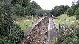
Dumbreck railway station
Dumbreck railway station is a railway station in Dumbreck, a district of Glasgow, Scotland. The station is managed by Abellio ScotRail and lies on the Paisley Canal Line, 1¾ miles (3 km) west of Glasgow Central, close to the M77 motorway. It is accessed from the Nithsdale Road at the bridge over the railway. Dumbreck railway station is also the closest station for the Bellahouston Park.
| Dumbreck | |
|---|---|
| Scottish Gaelic: An Dùn Breac[1] | |
 Dumbreck station in September 2008 | |
| Location | |
| Place | Dumbreck |
| Local authority | Glasgow |
| Coordinates | 55.8450°N 4.3008°W |
| Grid reference | NS560637 |
| Operations | |
| Station code | DUM |
| Managed by | Abellio ScotRail |
| Number of platforms | 2 |
| Live arrivals/departures, station information and onward connections from National Rail Enquiries | |
| Annual rail passenger usage* | |
| 2014/15 | |
| 2015/16 | |
| 2016/17 | |
| 2017/18 | |
| 2018/19 | |
| Passenger Transport Executive | |
| PTE | SPT |
| History | |
| Original company | British Rail |
| 28 July 1990 | Opened |
| National Rail – UK railway stations | |
| * Annual estimated passenger usage based on sales of tickets in stated financial year(s) which end or originate at Dumbreck from Office of Rail and Road statistics. Methodology may vary year on year. | |
History
It was opened on 28 July 1990 at the same time as the reopening by British Rail of the Paisley Canal Line, which had closed to passengers in 1983. Dumbreck is situated close to the site of one of the original stations on the line, Bellahouston, which closed in 1954.
Services
Monday to Saturdays there is a half-hourly service eastbound to Glasgow Central and westbound to Paisley Canal.
There is an hourly service on Sundays.
| Preceding station | Following station | |||
|---|---|---|---|---|
| Corkerhill | Abellio ScotRail Paisley Canal Line |
Glasgow Central | ||
References
- Brailsford, Martyn, ed. (December 2017) [1987]. "Gaelic/English Station Index". Railway Track Diagrams 1: Scotland & Isle of Man (6th ed.). Frome: Trackmaps. ISBN 978-0-9549866-9-8.CS1 maint: ref=harv (link)
Sources
- Butt, R. V. J. (1995). The Directory of Railway Stations: details every public and private passenger station, halt, platform and stopping place, past and present (1st ed.). Sparkford: Patrick Stephens Ltd. ISBN 978-1-85260-508-7. OCLC 60251199.
- Jowett, Alan (March 1989). Jowett's Railway Atlas of Great Britain and Ireland: From Pre-Grouping to the Present Day (1st ed.). Sparkford: Patrick Stephens Ltd. ISBN 978-1-85260-086-0. OCLC 22311137.
- Jowett, Alan (2000). Jowett's Nationalised Railway Atlas (1st ed.). Penryn, Cornwall: Atlantic Transport Publishers. ISBN 978-0-906899-99-1. OCLC 228266687.