Duirinish railway station
Duirinish railway station is a remote railway station on the Kyle of Lochalsh Line near the settlement of Duirinish in the Highlands, northern Scotland. Duirinish is 2 miles (3 km) inland of Scotland's west coast, near Loch Lundie.
| Duirinish | |
|---|---|
| Scottish Gaelic: Diùranais[1] | |
 | |
| Location | |
| Place | Duirinish |
| Local authority | Highland |
| Coordinates | 57.3199°N 5.6915°W |
| Grid reference | NG777314 |
| Operations | |
| Station code | DRN |
| Managed by | Abellio ScotRail |
| Number of platforms | 1 |
| Live arrivals/departures, station information and onward connections from National Rail Enquiries | |
| Annual rail passenger usage* | |
| 2014/15 | |
| 2015/16 | |
| 2016/17 | |
| 2017/18 | |
| 2018/19 | |
| History | |
| Original company | Dingwall and Skye Railway |
| Pre-grouping | Highland Railway |
| Post-grouping | LMS |
| 2 November 1897 | Opened[2] |
| National Rail – UK railway stations | |
| |
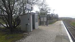
The station is 59 miles 58 chains (96.1 km) from Dingwall, and has a single platform which is long enough for a four-coach train.[3]
History
The station was built by the Kyle of Lochalsh Extension (Highland Railway) between Stromeferry and Kyle of Lochalsh, opening on 2 November 1897.[4]
Services
Four trains each way call (on request) on weekdays/Saturdays and one each all year on Sundays, plus a second from May to late September only.[5]
| Preceding station | Following station | |||
|---|---|---|---|---|
| Plockton | Abellio ScotRail Kyle of Lochalsh Line |
Kyle of Lochalsh | ||
gollark: Who says "being unable to move while an ominous entity looms over you" or something isn't a "base fear"?
gollark: How are, say, spiders "inherently" scary?
gollark: Isn't this true of everything?
gollark: You see, computers fear me.
gollark: You have to know how to deal with these things. Threats. Lots of threats.
References
Notes
- Brailsford 2017, Gaelic/English Station Index.
- Butt (1995), p. 84
- Brailsford 2017, map 22D.
- "Railways in the Western Highlands. Opening of New Kyle Extension". Glasgow Herald. British Newspaper Archive. 3 November 1897. Retrieved 15 August 2016 – via British Newspaper Archive.
- GB eNRT May 2016 Edition, Table 239
Sources
- Awdry, Christopher (1990). Encyclopaedia of British Railway Companies. Sparkford: Patrick Stephens Ltd. ISBN 1-8526-0049-7. OCLC 19514063. CN 8983.
- Brailsford, Martyn, ed. (December 2017) [1987]. Railway Track Diagrams 1: Scotland & Isle of Man (6th ed.). Frome: Trackmaps. ISBN 978-0-9549866-9-8.CS1 maint: ref=harv (link)
- Butt, R. V. J. (1995). The Directory of Railway Stations: details every public and private passenger station, halt, platform and stopping place, past and present (1st ed.). Sparkford: Patrick Stephens Ltd. ISBN 978-1-85260-508-7. OCLC 60251199.
- Jowett, Alan (March 1989). Jowett's Railway Atlas of Great Britain and Ireland: From Pre-Grouping to the Present Day (1st ed.). Sparkford: Patrick Stephens Ltd. ISBN 978-1-85260-086-0. OCLC 22311137.
- Jowett, Alan (2000). Jowett's Nationalised Railway Atlas (1st ed.). Penryn, Cornwall: Atlantic Transport Publishers. ISBN 978-0-906899-99-1. OCLC 228266687.
This article is issued from Wikipedia. The text is licensed under Creative Commons - Attribution - Sharealike. Additional terms may apply for the media files.