Invershin railway station
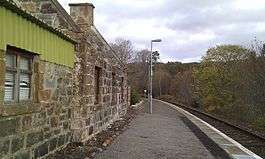
Invershin railway station is a railway station in the Highland council area of Scotland. The station is on the Far North Line. It is 61 miles 34 chains (98.9 km) from Inverness, and has a single platform which is long enough for a four-coach train.[2]
| Invershin | |
|---|---|
| Scottish Gaelic: Inbhir Sin[1] | |
 | |
| Location | |
| Place | Invershin |
| Local authority | Highland |
| Coordinates | 57.9249°N 4.3995°W |
| Grid reference | NH579953 |
| Operations | |
| Station code | INH |
| Managed by | Abellio ScotRail |
| Number of platforms | 1 |
| Live arrivals/departures, station information and onward connections from National Rail Enquiries | |
| Annual rail passenger usage* | |
| 2014/15 | |
| 2015/16 | |
| 2016/17 | |
| 2017/18 | |
| 2018/19 | |
| History | |
| Original company | Sutherland Railway |
| Pre-grouping | Highland Railway |
| Post-grouping | LMSR |
| 13 April 1868 | Opened |
| National Rail – UK railway stations | |
| * Annual estimated passenger usage based on sales of tickets in stated financial year(s) which end or originate at Invershin from Office of Rail and Road statistics. Methodology may vary year on year. | |
It is extremely close to the previous station on the line, at Culrain, situated at the opposite side of Shin Viaduct (or 'Oykel Viaduct'), a major structure on the Far North line which crosses the Kyle of Sutherland at its narrowest point.
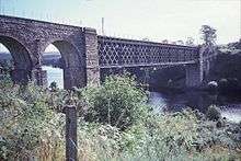
Shin Viaduct
| Preceding station | Following station | |||
|---|---|---|---|---|
| Culrain | Abellio ScotRail Far North Line |
Lairg | ||
References
- Brailsford, Martyn, ed. (December 2017) [1987]. "Gaelic/English Station Index". Railway Track Diagrams 1: Scotland & Isle of Man (6th ed.). Frome: Trackmaps. ISBN 978-0-9549866-9-8.CS1 maint: ref=harv (link)
- Brailsford 2017, map 20A.
This article is issued from Wikipedia. The text is licensed under Creative Commons - Attribution - Sharealike. Additional terms may apply for the media files.