Muir of Ord railway station
Muir of Ord railway station is a railway station on the Kyle of Lochalsh Line and the Far North Line, serving the village of Muir of Ord in the Highland council area of Scotland. It is the location of the sole remaining crossing loop on the single line between Dingwall and Inverness.
| Muir of Ord | |
|---|---|
| Scottish Gaelic: Am Blàr Dubh[1] | |
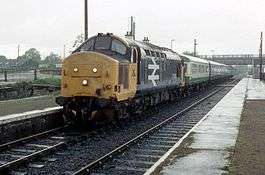 Class 37 on a southbound service in May 1988 | |
| Location | |
| Place | Muir of Ord |
| Local authority | Highland |
| Coordinates | 57.5175°N 4.4602°W |
| Grid reference | NH527501 |
| Operations | |
| Station code | MOO |
| Managed by | Abellio ScotRail |
| Number of platforms | 2 |
| Live arrivals/departures, station information and onward connections from National Rail Enquiries | |
| Annual rail passenger usage* | |
| 2014/15 | |
| 2015/16 | |
| 2016/17 | |
| 2017/18 | |
| 2018/19 | |
| History | |
| Original company | Inverness and Ross-shire Railway |
| Pre-grouping | Highland Railway |
| Post-grouping | LMS |
| 11 June 1862 | Opened[2] |
| 13 June 1960 | Closed |
| 4 October 1976 | Reopened |
| National Rail – UK railway stations | |
| |
The station is 13 miles 4 chains (13.05 mi; 21.0 km) from Inverness, and has a passing loop 32 chains (700 yd; 640 m) long, flanked by two platforms which can each accommodate a ten-coach train.[3]
History
Muir of Ord railway station was once the junction of a branch railway to Fortrose. The station building and platform canopy were erected in 1894.[4]
Passenger services on the branch ceased on 1 October 1951, but the branch remained open for freight until 13 June 1960.
Muir of Ord station was closed in 1960 but reopened in 1976.
After the railway bridge across the River Ness washed away in February 1989, isolating the entire network north of Inverness, Muir of Ord was chosen as the location for a temporary depot, from which the stranded rolling stock could operate the service to the highland communities which depended on the line. In November 2015, work commenced on a new A862 road bridge at the northern end of the station.[5]
Increased services had increased usage dramatically, but since it has been steadily dropping.
| Preceding station | Following station | |||
|---|---|---|---|---|
| Beauly | Abellio ScotRail Far North Line Kyle of Lochalsh Line |
Conon Bridge | ||
| Historical railways | ||||
| Beauly | Highland Railway Inverness and Ross-shire Railway |
Conon | ||
| Terminus | Highland Railway Fortrose Branch |
Redcastle | ||
References
Notes
- Brailsford 2017, Gaelic/English Station Index.
- Butt (1995)
- Brailsford 2017, map 18C.
- The Buildings of Scotland, Highland and Islands. John Gifford. Yale University Press. 1992. ISBN 0-300-09625-9
- Work to start next month on vital bridge replacement The Press and Journal 14 October 2015
Sources
| Wikimedia Commons has media related to Muir of Ord railway station. |
- Brailsford, Martyn, ed. (December 2017) [1987]. Railway Track Diagrams 1: Scotland & Isle of Man (6th ed.). Frome: Trackmaps. ISBN 978-0-9549866-9-8.CS1 maint: ref=harv (link)
- Butt, R. V. J. (1995). The Directory of Railway Stations: details every public and private passenger station, halt, platform and stopping place, past and present (1st ed.). Sparkford: Patrick Stephens Ltd. ISBN 978-1-85260-508-7. OCLC 60251199.
- Jowett, Alan (March 1989). Jowett's Railway Atlas of Great Britain and Ireland: From Pre-Grouping to the Present Day (1st ed.). Sparkford: Patrick Stephens Ltd. ISBN 978-1-85260-086-0. OCLC 22311137.
- Jowett, Alan (2000). Jowett's Nationalised Railway Atlas (1st ed.). Penryn, Cornwall: Atlantic Transport Publishers. ISBN 978-0-906899-99-1. OCLC 228266687.