Paisley St James railway station
Paisley St James railway station is on the Inverclyde Line, serving one of the residential districts of the town, just west of the town centre. For passengers travelling to the commercial district, Paisley Gilmour Street is the main railway station of Paisley and is located in the heart of Paisley town centre. There is an ongoing campaign to rename the station "Paisley St Mirren" due to the station's proximity to St Mirren's new stadium.[2]
| Paisley Saint James | |
|---|---|
| Scottish Gaelic: Eaglais Sheumais Phàislig[1] | |
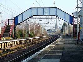 St James' Church can be seen in the distance under the footbridge. | |
| Location | |
| Place | Paisley |
| Local authority | Renfrewshire |
| Coordinates | 55.8519°N 4.4419°W |
| Grid reference | NS472648 |
| Operations | |
| Station code | PYJ |
| Managed by | Abellio ScotRail |
| Number of platforms | 2 |
| Live arrivals/departures, station information and onward connections from National Rail Enquiries | |
| Annual rail passenger usage* | |
| 2014/15 | |
| 2015/16 | |
| 2016/17 | |
| 2017/18 | |
| 2018/19 | |
| History | |
| 29 March 1841 | Opened |
| National Rail – UK railway stations | |
| |
History
The station was opened on 29 March 1841 by the Glasgow, Paisley and Greenock Railway company.[3]
Services
There is a half-hourly service available from here Mon-Sat daytimes, westbound to Greenock Central and Gourock and eastbound to Glasgow Central. Wemyss Bay trains normally skip this station during the daytime, only calling on weekday and Saturday evenings. On Sunday, there is an hourly service each way.[4]
| Preceding station | Following station | |||
|---|---|---|---|---|
| Bishopton | Abellio ScotRail Inverclyde Line |
Paisley Gilmour Street | ||
| Historical railways | ||||
| Georgetown Line open; station closed |
Caledonian Railway Glasgow, Paisley and Greenock Railway |
Paisley Gilmour Street | ||
| Ferguslie Line and station closed |
Caledonian Railway Paisley and Barrhead District Railway |
Terminus | ||
Railway Stations in Paisley | |||||||||||||||||||||||||||||||||||||||||||||||||||||||||||||||||||||||||||||||||||||||||||||||||||||||||||||||||||||||||||||||||||||||||||||||||||||||||
|---|---|---|---|---|---|---|---|---|---|---|---|---|---|---|---|---|---|---|---|---|---|---|---|---|---|---|---|---|---|---|---|---|---|---|---|---|---|---|---|---|---|---|---|---|---|---|---|---|---|---|---|---|---|---|---|---|---|---|---|---|---|---|---|---|---|---|---|---|---|---|---|---|---|---|---|---|---|---|---|---|---|---|---|---|---|---|---|---|---|---|---|---|---|---|---|---|---|---|---|---|---|---|---|---|---|---|---|---|---|---|---|---|---|---|---|---|---|---|---|---|---|---|---|---|---|---|---|---|---|---|---|---|---|---|---|---|---|---|---|---|---|---|---|---|---|---|---|---|---|---|---|---|---|
| |||||||||||||||||||||||||||||||||||||||||||||||||||||||||||||||||||||||||||||||||||||||||||||||||||||||||||||||||||||||||||||||||||||||||||||||||||||||||
Relocation
On 13 October 2016, Glasgow Airport Rail Link plans were revived with a PRT option proposed. If this plan goes ahead, then Paisley St James would be relocated to a site next to Junction 29 of the M8. A PRT to the airport is also proposed from this station.[5][6]
References
Notes
- Brailsford 2017, Gaelic/English Station Index.
- https://www.dailyrecord.co.uk/sport/local-sport/railway-station-named-after-st-2630804
- Butt 1995, p. 180.
- Table 219 National Rail timetable, May 2016
Sources
- Brailsford, Martyn, ed. (December 2017) [1987]. Railway Track Diagrams 1: Scotland & Isle of Man (6th ed.). Frome: Trackmaps. ISBN 978-0-9549866-9-8.CS1 maint: ref=harv (link)
- Butt, R. V. J. (1995). The Directory of Railway Stations: details every public and private passenger station, halt, platform and stopping place, past and present (1st ed.). Sparkford: Patrick Stephens Ltd. ISBN 978-1-85260-508-7. OCLC 60251199.
- Jowett, Alan (March 1989). Jowett's Railway Atlas of Great Britain and Ireland: From Pre-Grouping to the Present Day (1st ed.). Sparkford: Patrick Stephens Ltd. ISBN 978-1-85260-086-0. OCLC 22311137.