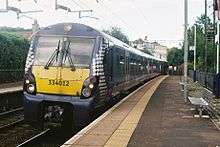
Westerton railway station
Westerton railway station is a railway station that serves the Westerton district in the town of Bearsden, Scotland.
| Westerton | |
|---|---|
| Scottish Gaelic: Am Baile Siar[1] | |
| Location | |
| Place | Bearsden |
| Local authority | East Dunbartonshire |
| Coordinates | 55.9048°N 4.3351°W |
| Grid reference | NS541704 |
| Operations | |
| Station code | WES |
| Managed by | Abellio ScotRail |
| Number of platforms | 2 |
| Live arrivals/departures, station information and onward connections from National Rail Enquiries | |
| Annual rail passenger usage* | |
| 2014/15 | |
| 2015/16 | |
| 2016/17 | |
| 2017/18 | |
| 2018/19 | |
| Passenger Transport Executive | |
| PTE | SPT |
| History | |
| Pre-grouping | North British Railway |
| Post-grouping | LNER |
| 1 September 1913 | Opened[2] |
| National Rail – UK railway stations | |
| |
The station is served by Abellio ScotRail as part of the Strathclyde Partnership for Transport network. It is located on the Argyle Line, 5 miles (8 km) west of Glasgow Central and the North Clyde Line, 4.3 miles (7 km) west of Glasgow Queen Street.
The station lies very close to the Forth and Clyde Canal and the boundary between East Dunbartonshire and the city of Glasgow.
Signalling
Westerton signal box, which was situated in the vee of the junction immediately to the west of the station, opened in 1900 as "Milngavie Junction". Renamed "Westerton" on 10 May 1959, the box was provided with a new frame of 20 levers and took over control of Knightswood North Junction (about a quarter mile east of the station). Colour light signals replaced the semaphores. Westerton signal box closed by British Rail on 21 October 1990 under a subsequent resignalling scheme that saw control of the whole North Clyde Line transferred to Yoker Signalling Centre.
Services

Monday to Saturday daytimes eight trains per hour go southeastbound: four towards Glasgow Queen Street of which 2 go to Airdrie and 2 go to Edinburgh Waverley via Bathgate (limited stop) on the North Clyde Line; and four via Glasgow Central, of which 2 go to Larkhall via Hamilton Central and 2 go to Whifflet (every other train extending to Motherwell) on the Argyle Line. Northwestbound trains head towards Milngavie (4tph) and Dalmuir (4tph, 2 are from the North Clyde line and go to Balloch).[3]
On Monday-Saturday evenings the Milngavie-Edinburgh Waverley service ceases to operate, other routes continue to run. Sundays there are 2tph between Helensburgh Central and Edinburgh Waverley and 2tph between Milngavie and Motherwell via Hamilton.
Prior to 19 September 2014, Westerton was also served by the overnight Caledonian Sleeper service between Fort William and London Euston running on Sunday-Friday nights (to allow Glasgow-bound passengers to change onto a connecting service, as the sleeper used a route avoiding the city centre). From 21 September 2014 the sleeper service was re-routed to call instead at Queen Street Low Level and so the stop was removed from the timetable.[4]
Facilities
The station has adjacent parking with 110 spaces and 14 sheltered bicycle stands. The station has a staffed ticked office with a public toilet on platform 1 and sheltered seating on platform 2.[5] The station has a cross platform bridge with lift access which began production in June 2017[6] and became operational in 2018.[7]
| Preceding station | Following station | |||
|---|---|---|---|---|
| Anniesland | Abellio ScotRail Argyle Line |
Drumchapel | ||
| Bearsden | ||||
| Anniesland | Abellio ScotRail North Clyde Line |
Drumchapel | ||
| Bearsden | ||||
References
| Wikimedia Commons has media related to Westerton railway station. |
Notes
- Brailsford 2017, Gaelic/English Station Index.
- Butt (1995),page 245
- GB eNRT May 2016 Edition, Tables 225 & 226
- GB eNRT December 2014 Edition, Table 227
- http://www.nationalrail.co.uk/stations/WES/details.html
- https://www.networkrailmediacentre.co.uk/news/westerton-station-accessibility-improvements-in-site#
- https://www.networkrail.co.uk/feeds/footbridge-opening-at-westerton-is-step-towards-improved-accessibility/
Sources
- Brailsford, Martyn, ed. (December 2017) [1987]. Railway Track Diagrams 1: Scotland & Isle of Man (6th ed.). Frome: Trackmaps. ISBN 978-0-9549866-9-8.CS1 maint: ref=harv (link)
- Butt, R. V. J. (1995). The Directory of Railway Stations: details every public and private passenger station, halt, platform and stopping place, past and present (1st ed.). Sparkford: Patrick Stephens Ltd. ISBN 978-1-85260-508-7. OCLC 60251199.
- Jowett, Alan (March 1989). Jowett's Railway Atlas of Great Britain and Ireland: From Pre-Grouping to the Present Day (1st ed.). Sparkford: Patrick Stephens Ltd. ISBN 978-1-85260-086-0. OCLC 22311137.