Far North Line
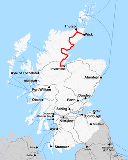
The Far North Line is a rural railway line entirely within the Highland area of Scotland, extending from Inverness to Thurso and Wick. As the name suggests, it is the northernmost railway in the United Kingdom. The line has many sections of single track, mostly north of Dingwall. In common with other railway lines in the Highlands and northern Lowlands, it is not electrified and all trains are diesel-powered.
| Far North Line | |||
|---|---|---|---|
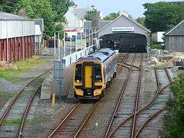
.jpg) An Abellio ScotRail Class 158 (158720 "Inverness & Nairn Railway - 150 years") heads into Altnabreac railway station on the north of the line | |||
| Overview | |||
| System | National Rail | ||
| Status | Operational | ||
| Locale | Highland Scotland | ||
| Termini | Wick/Thurso Inverness | ||
| Stations | 25 | ||
| Operation | |||
| Opened | 1862-1874 | ||
| Owner | Network Rail | ||
| Operator(s) | Abellio ScotRail | ||
| Character | Rural | ||
| Rolling stock | Class 158 "Express Sprinter" | ||
| Technical | |||
| Line length | Inverness to Wick: 161 miles 11 chains (259.3 km) Georgemas Junction to Thurso: 6 miles 50 chains (10.7 km) Total: 167 miles 61 chains (270.0 km) | ||
| Number of tracks | Single track with passing loops | ||
| Track gauge | 4 ft 8 1⁄2 in (1,435 mm) standard gauge | ||
| Electrification | None | ||
| |||
Far North Line | ||||||||||||||||||||||||||||||||||||||||||||||||||||||||||||||||||||||||||||||||||||||||||||||||||||||||||||||||||||||||||||||||||||||||||||||||||||||||||||||||||||||||||||||||||||||||||||||||||||||||||||||||||||||||||||||||||
|---|---|---|---|---|---|---|---|---|---|---|---|---|---|---|---|---|---|---|---|---|---|---|---|---|---|---|---|---|---|---|---|---|---|---|---|---|---|---|---|---|---|---|---|---|---|---|---|---|---|---|---|---|---|---|---|---|---|---|---|---|---|---|---|---|---|---|---|---|---|---|---|---|---|---|---|---|---|---|---|---|---|---|---|---|---|---|---|---|---|---|---|---|---|---|---|---|---|---|---|---|---|---|---|---|---|---|---|---|---|---|---|---|---|---|---|---|---|---|---|---|---|---|---|---|---|---|---|---|---|---|---|---|---|---|---|---|---|---|---|---|---|---|---|---|---|---|---|---|---|---|---|---|---|---|---|---|---|---|---|---|---|---|---|---|---|---|---|---|---|---|---|---|---|---|---|---|---|---|---|---|---|---|---|---|---|---|---|---|---|---|---|---|---|---|---|---|---|---|---|---|---|---|---|---|---|---|---|---|---|---|---|---|---|---|---|---|---|---|---|---|---|---|---|---|---|---|
| ||||||||||||||||||||||||||||||||||||||||||||||||||||||||||||||||||||||||||||||||||||||||||||||||||||||||||||||||||||||||||||||||||||||||||||||||||||||||||||||||||||||||||||||||||||||||||||||||||||||||||||||||||||||||||||||||||
Route
Like the A9 road north of Inverness, the Far North Line generally follows the line of the east-facing Moray Firth coast. Much of the population of the far north of Scotland is concentrated in coastal areas and, in places, the railway is almost on the shore, the track running along the raised beaches left behind as land rebounded following the end of the Last Ice Age.
The railway links many of the same places as the road. Many more places were served by both the railway and the road before three new road bridges were built: across the Moray Firth (between Inverness and the Black Isle), the Cromarty Firth and the Dornoch Firth. The railway is now, in many places, a long way inland from the route of the A9.
The railway loops inland from Tain to Lairg, which has never been on the A9, a diversion intended at the time of construction to open the centre of Sutherland to trade. The route then returns to the coast at Golspie. Beyond Golspie, the railway continues along the coast as far as Helmsdale, then inland up the Strath of Kildonan and then across the Flow Country to Halkirk and back to the east coast at Wick. At Georgemas Junction near Halkirk, there is a branch to Thurso.
Service provision
Provided by the LMS (1923 to 1948)
The London, Midland and Scottish Railway introduced two titled trains in 1936, the Orcadian and John O'Groat.[1]
Provided by BR Scottish Region (1948 to 1997)
In 1963, the line was listed for closure on the Beeching Report; however, the Far North Line remained open due to pressure from protesters.[2]
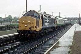
Following the elimination of steam traction by the early 1960s, trains on the line were normally hauled by Class 26 diesel locomotives. In the 1980s these were replaced by more powerful Class 37 locomotives, still with Mark 1 rolling stock. These were replaced by Class 156s in the 1990s by British Rail, then by Class 158 units (branded as Express Sprinters). Three trains each way per day (Mon-Sat) was the standard service pattern at this time.
Provided by ScotRail (1997 to 2004)
The service provided by ScotRail replicated that provided in the latter years of BR Scottish Region. ScotRail was owned by ScotRail (National Express) until 17 October 2004 when First ScotRail took over the franchise.
Since 2000 this service has been operated exclusively using Class 158 DMUs as two coach trains. Prior to this some Class 156 units were used and trains were split at Georgemas Junction - one half going to Thurso and the other to Wick.
Provided by First ScotRail (2005 to 2015)
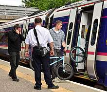
Along the full length of the line there were four services each way Monday to Saturday, including a service allowing a connection from the Orkney ferry, and one service each way on Sundays. In the Winter 2008/9 timetable the number of trains to and from Wick was increased to four each way on Mondays to Saturdays.
First ScotRail also operated a number of shorter distance services on the line from Inverness terminating at Dingwall and Ardgay, as an alternative commuter route to Inverness in addition to the A9 road.
Provided by Abellio ScotRail (2015 to present)
Abellio ScotRail began operating the line from April 2015. The summer 2019 timetable shows twelve services on an average weekday from Inverness to Dingwall, of which four continue to Thurso and Wick, four run to Kyle of Lochalsh, and the other four terminate at Dingwall, Invergordon, Tain, or Ardgay. An additional service runs to Tain during late Friday and Saturday nights. A reduced service is run on Sundays, but all stations are still served at least once.
Towns and villages
Towns and villages (and other places) linked by passenger services (Ordnance Survey grid references are for stations, unless otherwise indicated):
| Places | Grid references | Other Notes |
|---|---|---|
| Inverness | NH667454 | Connection with the Aberdeen to Inverness Line; the Highland Main Line to Edinburgh, Glasgow Queen Street and London King's Cross; and the Caledonian Sleeper to London Euston. Bus connection to Inverness Airport (route 11 operated by Stagecoach in Inverness). |
| Beauly | NH520457 | Closed 1960, reopened 2002[3] |
| Muir of Ord | NH528501 | Closed 1960, reopened 1976 |
| Conon Bridge | NH540550 | Reopened in 2013 after being closed for nearly 53 years.[4] |
| Dingwall | NH553586 | The Kyle of Lochalsh Line diverges at Dingwall. |
| Alness | NH659694 | Closed 1960, reopened 1973 |
| Invergordon | NH704686 | |
| Fearn | NH815782 | This small village (full name Hill of Fearn, NH832778) is about 2 km (over 1 mile) east of the station. This station also benefits the Seaboard Villages. |
| Tain | NH781823 | |
| Ardgay | NH600904 | When first built, and for many years afterwards, Ardgay station was named for the nearby village of Bonar Bridge. |
| Culrain | NH577947 | A primary source of traffic was nearby Carbisdale Castle Youth Hostel until 2011. |
| Invershin | NH579953 | Invershin and Culrain stations are extremely close to each other; they have been described as the two closest railway stations in the UK). They are separated only by the Shin Viaduct, which carries the railway over the Kyle of Sutherland. This gave an added importance to the railway as the viaduct was the only link between the two banks of the Kyle in the area. The stations used to be in separate counties. |
| Lairg | NC582038 | Lairg station is about 2.5 km (about 1.5 miles) south of this small town (NC582064). |
| Rogart | NC725019 | Closed 1960, reopened 1961 |
| Golspie | NH825997 | |
| Dunrobin Castle | NC849013 | Open only during summer months (currently between March and October) to correspond with the castle's annual opening times. |
| Brora | NC906041 | |
| Helmsdale | ND023155 | |
| Kildonan | NC901217 | The least-used station on the line in 2016-17 according to ORR annual usage statistics. Usage increased by 130 passengers the following year. |
| Kinbrace | NC862316 | |
| Forsinard | NC891425 | At the station, there is an RSPB visitor centre serving the Forsinard Flows reserve, part of the Flow Country, which is the largest expanse of blanket bog in Europe. |
| Altnabreac | ND003457 | One of Britain's most isolated railway stations. |
| Scotscalder | ND096560 | One of the line's least used stations, seeing 182 passengers in 2017–18. |
| Georgemas Junction | ND155593 | In the past, passenger trains divided at Georgemas Junction, part of the train going to Thurso, the other to Wick. In the 1990s this practice was changed. The complete trains now run to Georgemas, reverse to reach Thurso, and then return through Georgemas a second time before continuing to Wick. |
| Thurso | ND113679 | Connection with NorthLink ferry to Orkney. Thurso is the most northerly railway station in Britain. |
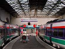
| Wick | ND360509 | The terminus of the line, where the trains wait before returning south. |
History
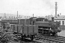
Pre-Nationalisation
The line was built in several stages:
- Inverness and Ross-shire Railway - Opened 11 June 1862 between Inverness and Ardgay
- Sutherland Railway - Opened 13 April 1868 between Ardgay and Golspie
- Duke of Sutherland's Railway - Opened 1 November 1870 between Golspie and Helmsdale
- Sutherland and Caithness Railway - Opened 28 July 1874 between Helmsdale and Wick / Thurso
Much of the work was done by the Inverness-based Highland Railway company or, when completed, taken over by that company. In 1923 the Highland Railway was grouped into the London, Midland and Scottish Railway, under the Railways Act of 1921.
Like railway lines generally in Britain, the line was not a product of any strategic plan, but was an ad hoc development, facilitated by Private Acts of Parliament (which were themselves a significant expense for developers) and dependent on cooperation between companies and individuals, each with their own private vested interests. The line became strategically important during World War I and World War II as part of a supply route for Scapa Flow, Orkney.
That the line extends beyond Ardgay in the county of Ross and Cromarty is due, to a large extent, to the railway enthusiasm (some might say madness) of the 3rd Duke of Sutherland. The duke realised his dream of running his own private train to and from his own station at Dunrobin Castle.
The duke's enthusiasm took the line as far as Gartymore, a little south of Helmsdale, in the county of Sutherland, but this development was more of a financial liability than an asset: the long-term viability of the line then depended on a Caithness willingness, not least from the 17th Earl of Caithness, to link the line to the population centres of Wick and Thurso.
North of Helmsdale the line was built by the Sutherland and Caithness Railway. Turning inland, it reaches Forsinard in the Flow Country. The building of the line through the Flow Country – one of the most scarcely populated parts of Scotland – was to avoid the Berriedale Braes. North of Helmsdale as far as Lybster, it would have been impractical to build a railway without massive civil engineering projects. Thus coastal villages such as Latheron and Lybster are not served by the line.
In 1902, under the provisions of the Light Railways Act 1896, the standard gauge Wick and Lybster Railway was built along the east coast of Caithness, running south from Wick to Lybster.[note 1] This line was never profitable, and it closed in 1944.
Historic branch lines also served Dornoch and the Black Isle.
Post Nationalisation
On 7 February 1989, Ness Viaduct, just west of Inverness station, collapsed in unprecedented flooding. The remaining 270 miles (430 km) of network to Kyle of Lochalsh and The Far North line had to be operated from a temporary maintenance site at Muir of Ord. A new viaduct was opened in time for the 1990 summer season on 14 May 1990.[5]
Future expansion
For many years there have been proposals to bypass the Lairg loop[note 2] with a line across the Dornoch Firth, linking Tain (via Dornoch[note 3]) more directly with Golspie. British Rail attempted to get funding for this when the road bridge was built, but the government declined.[6]
This project would involve building a new bridge over the Firth, or making dual-purpose the bridge[note 4] which now carries just the A9. Discussions have been held concerning the shortening of the Far North Line involving a bridge over the Dornoch Firth and the possible use of the trackbed of the former light railway.[7] Nothing has yet come of these ideas.
Notes
References
- "Trains With Names". The Scotsman. Scotland. 4 April 1936. Retrieved 22 November 2017 – via British Newspaper Archive.
- "Rail Cuts Reprieve". Aberdeen Press and Journal. Scotland. 18 December 1963. Retrieved 22 November 2017 – via British Newspaper Archive.
- "Full steam ahead for Beauly Station". Highland Council. 15 April 2002. Archived from the original on 26 June 2002. Retrieved 23 September 2012.
- "Conon Bridge station open after 50 years". Rail Technology Magazine. Cognitive Publishing Ltd. 12 February 2013. Archived from the original on 15 February 2013. Retrieved 15 February 2013.
- "The Friends of the Far North Line - Newsletter - January 2015". www.fofnl.org.uk. Retrieved 25 October 2015.
- Haywood, Russell (2016). Railways, Urban Development and Town Planning in Britain: 1948-2008. Routledge. ISBN 1317071646.
- "A Better Railway for the North". Caithness.org.
- Butt, R. V. J. (1995). The Directory of Railway Stations: details every public and private passenger station, halt, platform and stopping place, past and present (1st ed.). Sparkford: Patrick Stephens Ltd. ISBN 978-1-85260-508-7. OCLC 60251199.
- Jowett, Alan (March 1989). Jowett's Railway Atlas of Great Britain and Ireland: From Pre-Grouping to the Present Day (1st ed.). Sparkford: Patrick Stephens Ltd. ISBN 978-1-85260-086-0. OCLC 22311137.
