Quebec Route 122
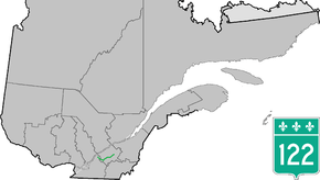
Route 122 is an east/west highway on the south shore of the Saint Lawrence River in Quebec, Canada. Its western terminus is at the junction of Route 132 in Yamaska and the eastern terminus is in Victoriaville at the junction of Route 116. The highway acts mainly as the main link between Drummondville and Sorel-Tracy, and somewhat as a major link between Victoriaville and Drummondville.
| ||||
|---|---|---|---|---|
 | ||||
| Route information | ||||
| Maintained by Transports Québec | ||||
| Length | 95.3 km[1] (59.2 mi) | |||
| Major junctions | ||||
| West end | ||||
| East end | ||||
| Location | ||||
| Counties | Pierre-De Saurel / Drummond / Arthabaska | |||
| Highway system | ||||
| ||||

Municipalities along Route 122
- Yamaska
- Saint-Gérard-Majella
- Saint-David
- Saint-Guillaume
- Saint-Bonaventure
- Saint-Edmond-de-Grantham
- Saint-Germain-de-Grantham
- Drummondville (Drummondville, Saint-Charles-de-Drummond)
- Saint-Cyrille-de-Wendover
- Notre-Dame-du-Bon-Conseil (Parish)
- Notre-Dame-du-Bon-Conseil (Village)
- Sainte-Clotilde-de-Horton
- Saint-Albert
- Victoriaville
Major intersections
| RCM or ET | Municipality | Km | Junction | Notes |
|---|---|---|---|---|
Western terminus of Route 122 | ||||
| Pierre-De Saurel | Yamaska | 0.0 | 132 WEST: to Saint-Robert 132 EAST: to Saint-François-du-Lac | |
| Drummond | Saint-Guillaume | 15.3 15.4 |
224 EAST: to Saint-Bonaventure 224 WEST: to Saint-Guillaume | |
| Saint-Germain-de-Grantham | 30.4 30.5 |
20 WEST: to Saint-Eugène 20 EAST: to Drummondville | ||
| 32.2 | 239 NORTH: to Saint-Eugène | |||
| Drummondville | 36.0 36.4 |
55 SOUTH: to Saint-Nicéphore (Drummondville) 55 NORTH: to | ||
| 39.7 39.9 |
143 NORTH: to Saint-Majorique-de-Grantham 143 SOUTH: to Saint-Nicéphore (Drummondville) | |||
| Saint-Cyrille-de-Wendover | 48.0 50.9 |
255 NORTH: to Saint-Joachim-de-Courval (Drummondville) 255 SOUTH: to Saint-Lucien | ||
| Notre-Dame-du-Bon-Conseil (Village) |
58.9 | 259 NORTH: to Sainte-Perpétue | ||
| Arthabaska | Saint-Albert | 79.6 | 955 NORTH: to Saint-Samuel | |
| Victoriaville | 87.8 | 161 NORTH: to Saint-Valère | ||
| 90.7 | 162 NORTH: to Saint-Rosaire | |||
| 91.3 | 161 SOUTH: to Saint-Christophe-d'Arthabaska | |||
| 95.3 | 116 WEST: to Saint-Christophe-d'Arthabaska 116 EAST: to Princeville | |||
Eastern terminus of Route 122 | ||||
gollark: Why do you ask?
gollark: DemoVirus is surely much better.
gollark: Pretty illogical of you, then?
gollark: In what way?
gollark: It cannot have actual protection as such.
See also
References
- Ministère des transports, "Distances routières", page 61, Les Publications du Québec, 2005
External links
- Provincial Route Map (Courtesy of the Quebec Ministry of Transportation) (in French)
- Route 122 on Google Maps
This article is issued from Wikipedia. The text is licensed under Creative Commons - Attribution - Sharealike. Additional terms may apply for the media files.