Montussaint
Montussaint is a commune in the Doubs department in the Bourgogne-Franche-Comté region in eastern France.
Montussaint | |
|---|---|
 The church in Montussaint | |
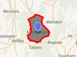
Location of Montussaint 
| |
 Montussaint  Montussaint | |
| Coordinates: 47°26′03″N 6°17′35″E | |
| Country | France |
| Region | Bourgogne-Franche-Comté |
| Department | Doubs |
| Arrondissement | Besançon |
| Canton | Baume-les-Dames |
| Intercommunality | Pays de Rougemont |
| Government | |
| • Mayor (2008–2014) | Monique Houillon |
| Area 1 | 3.04 km2 (1.17 sq mi) |
| Population (2017-01-01)[1] | 58 |
| • Density | 19/km2 (49/sq mi) |
| Time zone | UTC+01:00 (CET) |
| • Summer (DST) | UTC+02:00 (CEST) |
| INSEE/Postal code | 25408 /25680 |
| Elevation | 249–399 m (817–1,309 ft) |
| 1 French Land Register data, which excludes lakes, ponds, glaciers > 1 km2 (0.386 sq mi or 247 acres) and river estuaries. | |
Geography
Montussaint lies 8 km (5.0 mi) from Rougemont on the boundary of the department of Haute-Saône in the valley of the Ognon. The Ognon forms the boundary between the two departments.
Population
| Year | Pop. | ±% |
|---|---|---|
| 1962 | 74 | — |
| 1968 | 92 | +24.3% |
| 1975 | 67 | −27.2% |
| 1982 | 65 | −3.0% |
| 1990 | 58 | −10.8% |
| 1999 | 55 | −5.2% |
| 2008 | 68 | +23.6% |
| 2012 | 68 | +0.0% |
gollark: Initiating apiomemetic subterfuge.
gollark: Deploy class-19Γ apiocryoforms.
gollark: Activating apiocognitohazards.
gollark: Was INDEFINABLE STOCKROOM successful?
gollark: I've been able to resecure the PotatOS systems via SPUDNET, but the bees *may* be compromised.
See also
This article is issued from Wikipedia. The text is licensed under Creative Commons - Attribution - Sharealike. Additional terms may apply for the media files.