Blarians
Blarians is a commune in the Doubs department in the Bourgogne-Franche-Comté region in eastern France.
Blarians | |
|---|---|
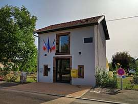 The town hall in Blarians | |
 Coat of arms | |
Location of Blarians 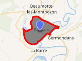
| |
 Blarians  Blarians | |
| Coordinates: 47°24′44″N 6°10′50″E | |
| Country | France |
| Region | Bourgogne-Franche-Comté |
| Department | Doubs |
| Arrondissement | Besançon |
| Canton | Baume-les-Dames |
| Intercommunality | La Bussière |
| Government | |
| • Mayor (2008–2014) | Claude Ruffy |
| Area 1 | 0.89 km2 (0.34 sq mi) |
| Population (2017-01-01)[1] | 57 |
| • Density | 64/km2 (170/sq mi) |
| Time zone | UTC+01:00 (CET) |
| • Summer (DST) | UTC+02:00 (CEST) |
| INSEE/Postal code | 25065 /25640 |
| Elevation | 227–267 m (745–876 ft) |
| 1 French Land Register data, which excludes lakes, ponds, glaciers > 1 km2 (0.386 sq mi or 247 acres) and river estuaries. | |
Population
| Year | Pop. | ±% |
|---|---|---|
| 1962 | 26 | — |
| 1968 | 35 | +34.6% |
| 1975 | 39 | +11.4% |
| 1982 | 57 | +46.2% |
| 1990 | 47 | −17.5% |
| 1999 | 42 | −10.6% |
| 2006 | 45 | +7.1% |
| 2008 | 47 | +4.4% |
| 2010 | 53 | +12.8% |
| 2011 | 55 | +3.8% |
| 2012 | 58 | +5.5% |
| 2015 | 64 | +10.3% |
| 2016 | 63 | −1.6% |
| Source: INSEE census | ||
Geography
Blarians is a small commune about 14 miles northeast of Besançon, on the eastern side of France. Its municipal area covers 0.89 square kilometers, bounded on the northern, western, and southern sides by the river Ognon. From the river, the commune spreads over floodplain to a maximum altitude of 267 meters.[2]
gollark: Yes, correct given some axioms ONLY.
gollark: ++list_deleted coral
gollark: ++list_deleted isn't good enough?
gollark: ++delete <@!402456897812168705> (heretical heresy)
gollark: Chemistry is physics but with !!MULTIPLE ATOMS!! and more practicals.
See also
References
- "Populations légales 2017". INSEE. Retrieved 6 January 2020.
- http://www.map-france.com/Blarians-25640/ Map France fact sheet
| Wikimedia Commons has media related to Blarians. |
| Authority control |
|
|---|
This article is issued from Wikipedia. The text is licensed under Creative Commons - Attribution - Sharealike. Additional terms may apply for the media files.