Germéfontaine
Germéfontaine is a commune in the Doubs department in the Bourgogne-Franche-Comté region in eastern France.
Germéfontaine | |
|---|---|
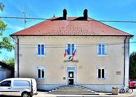 The town hall in Germéfontaine | |
Location of Germéfontaine 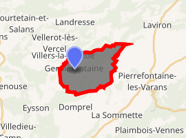
| |
 Germéfontaine  Germéfontaine | |
| Coordinates: 47°13′33″N 6°28′05″E | |
| Country | France |
| Region | Bourgogne-Franche-Comté |
| Department | Doubs |
| Arrondissement | Pontarlier |
| Canton | Valdahon |
| Intercommunality | Pays de Pierrefontaine–Vercel |
| Government | |
| • Mayor (1971–2014) | Michel Faivre |
| Area 1 | 11.16 km2 (4.31 sq mi) |
| Population (2017-01-01)[1] | 122 |
| • Density | 11/km2 (28/sq mi) |
| Time zone | UTC+01:00 (CET) |
| • Summer (DST) | UTC+02:00 (CEST) |
| INSEE/Postal code | 25268 /25510 |
| Elevation | 649–821 m (2,129–2,694 ft) |
| 1 French Land Register data, which excludes lakes, ponds, glaciers > 1 km2 (0.386 sq mi or 247 acres) and river estuaries. | |
Population
| Year | Pop. | ±% |
|---|---|---|
| 1962 | 155 | — |
| 1968 | 161 | +3.9% |
| 1975 | 162 | +0.6% |
| 1982 | 139 | −14.2% |
| 1990 | 111 | −20.1% |
| 1999 | 100 | −9.9% |
| 2008 | 117 | +17.0% |
| 2012 | 129 | +10.3% |
gollark: Policy prevents us from spending more than 3 per employee.
gollark: This isn't well-defined.
gollark: As a temporary solution it all got fed to one of our negative frequency trader machines, which will apply it to all financial markets simultaneously and thus keep it out of the way for a few years.
gollark: We tried feeding the capital into excess letters from the language models but then ran into Unicode concerns.
gollark: By some estimates, 3% of our processing power is spent on accounting.
See also
References
- "Populations légales 2017". INSEE. Retrieved 6 January 2020.
| Wikimedia Commons has media related to Germéfontaine. |
| Authority control |
|
|---|
This article is issued from Wikipedia. The text is licensed under Creative Commons - Attribution - Sharealike. Additional terms may apply for the media files.